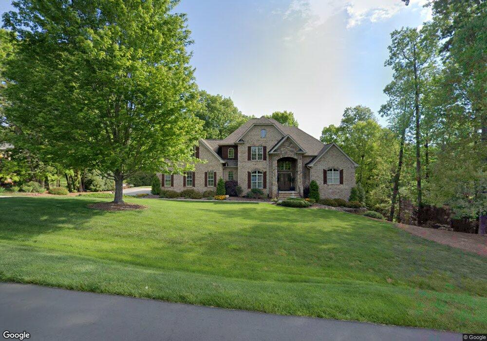
5012 Robdot Dr Oak Ridge, NC 27310
Estimated Value: $704,000 - $1,111,499
4
Beds
5
Baths
6,032
Sq Ft
$145/Sq Ft
Est. Value
About This Home
This home is located at 5012 Robdot Dr, Oak Ridge, NC 27310 and is currently estimated at $877,375, approximately $145 per square foot. 5012 Robdot Dr is a home located in Guilford County with nearby schools including Oak Ridge Elementary School, Northwest Guilford Middle School, and Northwest Guilford High School.
Ownership History
Date
Name
Owned For
Owner Type
Purchase Details
Closed on
Apr 12, 2006
Sold by
Fireside Homes Inc
Bought by
Corso Heath Martin and Corso Jennifer
Current Estimated Value
Home Financials for this Owner
Home Financials are based on the most recent Mortgage that was taken out on this home.
Original Mortgage
$424,280
Interest Rate
6.2%
Mortgage Type
Fannie Mae Freddie Mac
Create a Home Valuation Report for This Property
The Home Valuation Report is an in-depth analysis detailing your home's value as well as a comparison with similar homes in the area
Home Values in the Area
Average Home Value in this Area
Purchase History
| Date | Buyer | Sale Price | Title Company |
|---|---|---|---|
| Corso Heath Martin | $530,500 | None Available |
Source: Public Records
Mortgage History
| Date | Status | Borrower | Loan Amount |
|---|---|---|---|
| Previous Owner | Corso Heath Martin | $424,280 |
Source: Public Records
Tax History Compared to Growth
Tax History
| Year | Tax Paid | Tax Assessment Tax Assessment Total Assessment is a certain percentage of the fair market value that is determined by local assessors to be the total taxable value of land and additions on the property. | Land | Improvement |
|---|---|---|---|---|
| 2025 | $5,107 | $547,300 | $70,000 | $477,300 |
| 2024 | $5,107 | $547,300 | $70,000 | $477,300 |
| 2023 | $5,107 | $547,300 | $70,000 | $477,300 |
| 2022 | $4,971 | $547,300 | $70,000 | $477,300 |
| 2021 | $4,678 | $515,100 | $50,000 | $465,100 |
| 2020 | $5,175 | $569,800 | $50,000 | $519,800 |
| 2019 | $5,175 | $569,800 | $0 | $0 |
| 2018 | $5,149 | $569,800 | $0 | $0 |
| 2017 | $5,149 | $569,800 | $0 | $0 |
| 2016 | $5,048 | $545,100 | $0 | $0 |
| 2015 | $5,075 | $545,100 | $0 | $0 |
| 2014 | $5,130 | $545,100 | $0 | $0 |
Source: Public Records
Map
Nearby Homes
- 5402 Effieham St
- 8280 Stafford Mill Rd
- 8235 Stafford Mill Rd
- 5216 Harley Stafford Dr
- 8304 Burchlawn Ct
- 4530 Peeples Rd
- 7856, 7864 Alcorn Rd
- 8104 Leabourne Rd
- 8323 Lazy Sky Ln Unit 69
- 3945 Cassillis Way Unit 105
- 8321 Lazy Sky Ln Unit 70
- 8314 Lazy Sky Ln Unit 112
- 3934 Cassillis Way Unit 110
- 3940 Cassillis Way Unit 107
- 3936 Cassillis Way Unit 109
- 8312 Lazy Sky Ln Unit 113
- 8317 Lazy Sky Ln Unit 100
- 8315 Lazy Sky Ln Unit 99
- 8308 Lazy Sky Ln Unit 115
- 8304 Lazy Sky Ln Unit 117
- 5010 Robdot Dr
- 5014 Robdot Dr
- 5008 Robdot Dr
- 5005 Robdot Dr
- 5401 Effieham St
- 8257 Stafford Mill Rd
- 5003 Robdot Dr
- 5006 Robdot Dr
- 5400 Effieham St
- 5403 Effieham St
- 8255 Stafford Mill Rd
- 5004 Robdot Dr
- 8276 Stafford Mill Rd
- 8252 Stafford Mill Rd Unit C
- 8252 Stafford Mill Rd
- 8302 Banager Rd
- 8300 Banager Rd
- 8279 Stafford Mill Rd
- 5002 Robdot Dr
- 5011 Leadenhall Rd