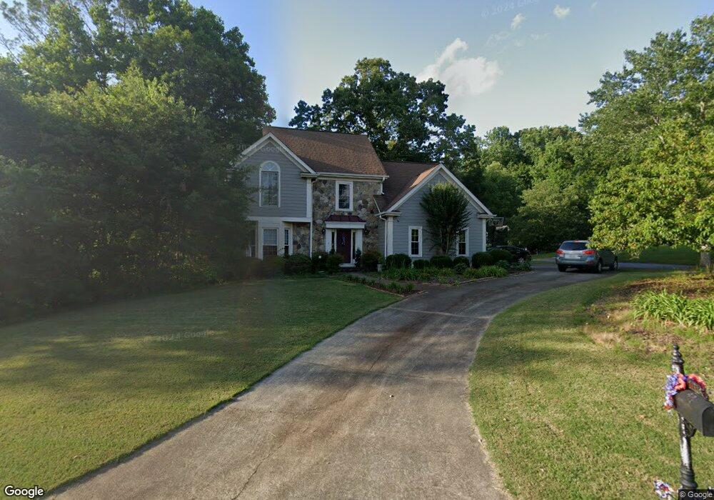
5012 Southland Dr Unit I Woodstock, GA 30188
Estimated Value: $486,000 - $503,875
4
Beds
3
Baths
2,412
Sq Ft
$205/Sq Ft
Est. Value
About This Home
This home is located at 5012 Southland Dr Unit I, Woodstock, GA 30188 and is currently estimated at $494,938, approximately $205 per square foot. 5012 Southland Dr Unit I is a home located in Cherokee County with nearby schools including Arnold Mill Elementary School, Mill Creek Middle School, and River Ridge High School.
Ownership History
Date
Name
Owned For
Owner Type
Purchase Details
Closed on
Jul 16, 2002
Sold by
Metza Lawrence E and Metza Lynette
Bought by
Delgais Michael E and Delgais Carol A
Current Estimated Value
Home Financials for this Owner
Home Financials are based on the most recent Mortgage that was taken out on this home.
Original Mortgage
$19,000
Outstanding Balance
$7,606
Interest Rate
6.06%
Mortgage Type
New Conventional
Estimated Equity
$487,332
Purchase Details
Closed on
Sep 7, 1994
Sold by
Barry Holder Inc
Bought by
Metza Lawrence Edward and Metza Lynette
Home Financials for this Owner
Home Financials are based on the most recent Mortgage that was taken out on this home.
Original Mortgage
$122,400
Interest Rate
7.5%
Create a Home Valuation Report for This Property
The Home Valuation Report is an in-depth analysis detailing your home's value as well as a comparison with similar homes in the area
Home Values in the Area
Average Home Value in this Area
Purchase History
| Date | Buyer | Sale Price | Title Company |
|---|---|---|---|
| Delgais Michael E | $190,000 | -- | |
| Metza Lawrence Edward | $153,000 | -- |
Source: Public Records
Mortgage History
| Date | Status | Borrower | Loan Amount |
|---|---|---|---|
| Open | Delgais Michael E | $19,000 | |
| Open | Delgais Michael E | $152,000 | |
| Closed | Delgais Michael E | $19,000 | |
| Previous Owner | Metza Lawrence Edward | $122,400 |
Source: Public Records
Tax History Compared to Growth
Tax History
| Year | Tax Paid | Tax Assessment Tax Assessment Total Assessment is a certain percentage of the fair market value that is determined by local assessors to be the total taxable value of land and additions on the property. | Land | Improvement |
|---|---|---|---|---|
| 2025 | $4,987 | $189,900 | $34,800 | $155,100 |
| 2024 | $4,900 | $188,560 | $34,800 | $153,760 |
| 2023 | $4,485 | $170,660 | $31,600 | $139,060 |
| 2022 | $4,126 | $157,000 | $28,800 | $128,200 |
| 2021 | $3,760 | $132,460 | $24,000 | $108,460 |
| 2020 | $3,337 | $117,440 | $17,600 | $99,840 |
| 2019 | $3,160 | $111,200 | $17,600 | $93,600 |
| 2018 | $2,871 | $100,440 | $17,600 | $82,840 |
| 2017 | $2,834 | $245,900 | $17,600 | $80,760 |
| 2016 | $2,701 | $231,900 | $16,800 | $75,960 |
| 2015 | $2,459 | $209,100 | $12,240 | $71,400 |
| 2014 | $2,305 | $195,600 | $12,240 | $66,000 |
Source: Public Records
Map
Nearby Homes
- 1486 Willow Bend
- 103 Branch Dr
- Magnolia Plan at Magnolia Reserve
- Chatham Plan at Magnolia Reserve
- Turnberry Plan at Magnolia Reserve
- Heritage Plan at Magnolia Reserve
- 119 Chateau Place
- 5305 Shotwell Ct Unit III
- 321 Knollwood Ln
- 212 Fernwood Place
- 120 Fernwood Dr
- LOT 4 Cox Rd
- LOT 3 Cox Rd
- LOT 2 Cox Rd
- Lot 1 Cox Rd
- 5103 Shotwell St
- 5014 Southland Dr
- 5011 Southland Dr
- 5102 Shotwell St
- 5105 Shotwell St Unit 1
- 5104 Shotwell St
- 5009 Southland Dr
- 5100 Southland Dr
- 5100 Southland Dr Unit 198
- 5106 Shotwell St
- 4502 Wedewer Way
- 5016 Southland Dr
- 4503 Wedewer Way
- 0 Wedewer Way
- 5108 Shotwell St
- 4901 Leeanns Way
- 5098 Southland Dr
- 5015 Southland Dr
- 5007 Southland Dr Unit 1
- 4903 Leeanns Way