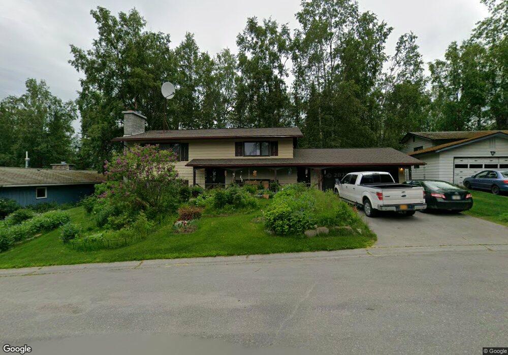
5015 Vance Dr Anchorage, AK 99508
University Area NeighborhoodEstimated Value: $199,000 - $471,536
4
Beds
3
Baths
1,120
Sq Ft
$331/Sq Ft
Est. Value
About This Home
This home is located at 5015 Vance Dr, Anchorage, AK 99508 and is currently estimated at $370,845, approximately $331 per square foot. 5015 Vance Dr is a home located in Anchorage Municipality with nearby schools including College Gate Elementary School, Wendler Middle School, and Bettye Davis East Anchorage High School.
Ownership History
Date
Name
Owned For
Owner Type
Purchase Details
Closed on
Mar 19, 2002
Sold by
Mason Gary L and Mason Audrey G
Bought by
Vaughan Richard O
Current Estimated Value
Home Financials for this Owner
Home Financials are based on the most recent Mortgage that was taken out on this home.
Original Mortgage
$198,178
Outstanding Balance
$80,727
Interest Rate
6.85%
Mortgage Type
FHA
Estimated Equity
$290,118
Create a Home Valuation Report for This Property
The Home Valuation Report is an in-depth analysis detailing your home's value as well as a comparison with similar homes in the area
Home Values in the Area
Average Home Value in this Area
Purchase History
| Date | Buyer | Sale Price | Title Company |
|---|---|---|---|
| Vaughan Richard O | -- | First American Title |
Source: Public Records
Mortgage History
| Date | Status | Borrower | Loan Amount |
|---|---|---|---|
| Open | Vaughan Richard O | $198,178 |
Source: Public Records
Tax History Compared to Growth
Tax History
| Year | Tax Paid | Tax Assessment Tax Assessment Total Assessment is a certain percentage of the fair market value that is determined by local assessors to be the total taxable value of land and additions on the property. | Land | Improvement |
|---|---|---|---|---|
| 2025 | $2,732 | $418,800 | $97,100 | $321,700 |
| 2024 | $2,732 | $394,200 | $97,100 | $297,100 |
| 2023 | $6,121 | $359,400 | $97,100 | $262,300 |
| 2022 | $2,652 | $357,500 | $97,100 | $260,400 |
| 2021 | $5,577 | $309,500 | $97,100 | $212,400 |
| 2020 | $1,933 | $314,900 | $97,100 | $217,800 |
| 2019 | $1,872 | $314,400 | $97,100 | $217,300 |
| 2018 | $1,925 | $317,400 | $97,100 | $220,300 |
| 2017 | $4,800 | $326,500 | $97,100 | $229,400 |
| 2016 | $4,030 | $319,900 | $95,200 | $224,700 |
| 2015 | $4,030 | $313,200 | $95,200 | $218,000 |
| 2014 | $4,030 | $296,600 | $86,700 | $209,900 |
Source: Public Records
Map
Nearby Homes
- 5018 E 43rd Ave Unit 5
- 5240 E 42nd Ave
- 3948 Boniface Pkwy
- 3910 Lynn Dr
- 3668 Little Bear Place Unit 6
- 3305 Briarcliff Dr
- 3310 Wells Cir
- 3651 Mirage Cir
- 4170 Defiance St
- 4109 Mclean Place
- 5941 Ridgelake Cir
- 3973 Defiance St
- 3215 Eastgate Place Unit 301
- 5934 Kody Dr Unit 7
- 6003 Kody Dr Unit 24
- 4719 Mills Dr Unit 24
- 6020 E 43rd Ave Unit 32
- 000 Wesleyan Dr
- 4838 Bryn Mawr Ct Unit 1
- 000 Delwood Place