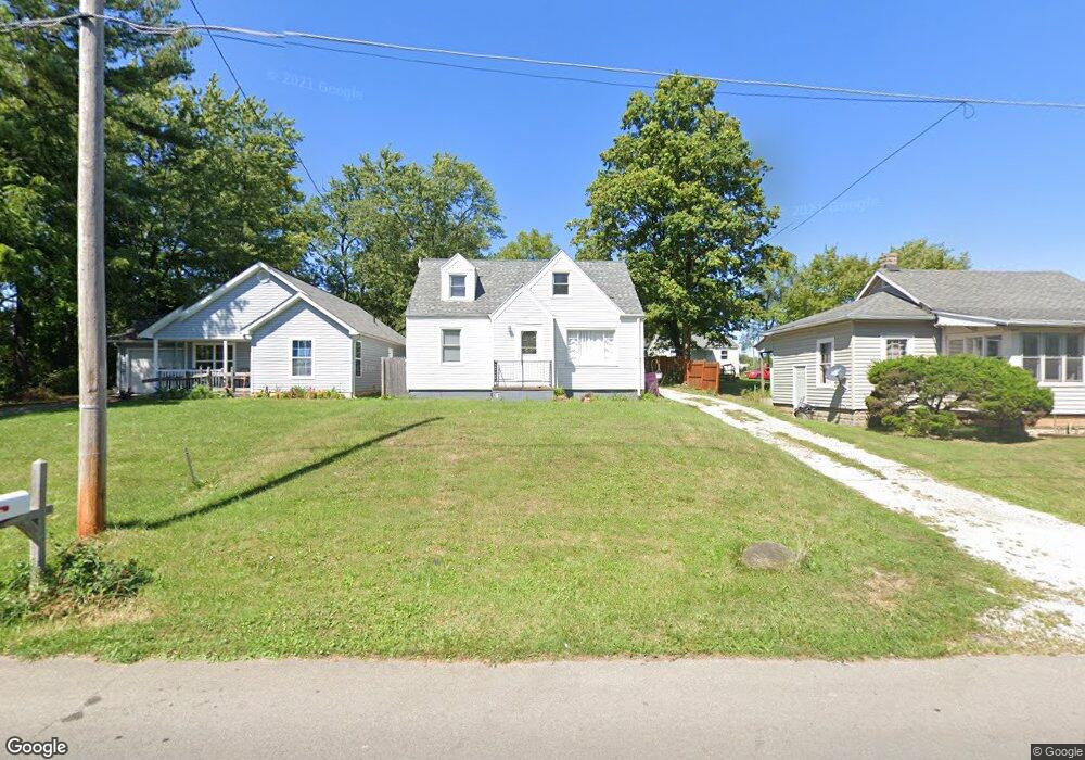
502 King St Mansfield, OH 44903
Estimated Value: $57,000 - $80,000
2
Beds
1
Bath
964
Sq Ft
$70/Sq Ft
Est. Value
About This Home
This home is located at 502 King St, Mansfield, OH 44903 and is currently estimated at $67,084, approximately $69 per square foot. 502 King St is a home located in Richland County with nearby schools including Foundation Academy, Mansfield Elective Academy, and Interactive Media & Construction (IMAC) Academy.
Ownership History
Date
Name
Owned For
Owner Type
Purchase Details
Closed on
Apr 25, 2019
Sold by
Strouse Steve
Bought by
Hale Belinda L and Hale Robert L
Current Estimated Value
Home Financials for this Owner
Home Financials are based on the most recent Mortgage that was taken out on this home.
Original Mortgage
$40,500
Outstanding Balance
$33,022
Interest Rate
4%
Mortgage Type
New Conventional
Estimated Equity
$34,062
Purchase Details
Closed on
May 5, 2016
Sold by
Central City Economic Development Counci
Bought by
Strouse Steve
Purchase Details
Closed on
Aug 20, 2003
Sold by
Central City Economic Development Counci
Bought by
Mansfield Homes Vi Llc
Create a Home Valuation Report for This Property
The Home Valuation Report is an in-depth analysis detailing your home's value as well as a comparison with similar homes in the area
Home Values in the Area
Average Home Value in this Area
Purchase History
We collect this data history from publicly available records. To have your information removed, we recommend requesting removal directly through your county’s website.
| Date | Buyer | Sale Price | Title Company |
|---|---|---|---|
| Hale Belinda L | $45,000 | Chicago Title | |
| Strouse Steve | -- | Chicago Title Agency Of N Ce | |
| Mansfield Homes Vi Llc | $5,000 | Chicago Title |
Source: Public Records
Mortgage History
We collect this data history from publicly available records. To have your information removed, we recommend requesting removal directly through your county’s website.
| Date | Status | Borrower | Loan Amount |
|---|---|---|---|
| Open | Hale Belinda L | $40,500 |
Source: Public Records
Tax History
| Year | Tax Paid | Tax Assessment Tax Assessment Total Assessment is a certain percentage of the fair market value that is determined by local assessors to be the total taxable value of land and additions on the property. | Land | Improvement |
|---|---|---|---|---|
| 2025 | $707 | $15,440 | $1,750 | $13,690 |
| 2024 | $707 | $15,440 | $1,750 | $13,690 |
| 2023 | $723 | $15,440 | $1,750 | $13,690 |
| 2022 | $713 | $12,770 | $1,590 | $11,180 |
| 2021 | $718 | $12,770 | $1,590 | $11,180 |
| 2020 | $751 | $12,770 | $1,590 | $11,180 |
| 2019 | $469 | $7,190 | $1,590 | $5,600 |
| 2018 | $463 | $7,190 | $1,590 | $5,600 |
| 2017 | $450 | $7,190 | $1,590 | $5,600 |
| 2016 | $272 | $4,210 | $2,650 | $1,560 |
| 2015 | $254 | $4,210 | $2,650 | $1,560 |
| 2014 | $250 | $4,210 | $2,650 | $1,560 |
| 2012 | $191 | $4,210 | $2,650 | $1,560 |
Source: Public Records
Map
Nearby Homes
- 516 Burns St
- 512 Burns St
- 0 Highway 30
- 375 Mcpherson St
- 0 State Route 314 Unit 9069650
- 688 Mcpherson St
- 495 Johns Ave
- 625 Sackman St
- 655 Bowman St
- 0 Lemley Ave Unit 9070540
- 0 Grant Rd Unit 5190994
- 524 Lida St
- 604 W 4th St
- 580 N Mulberry St
- 118 Raymond Ave
- 400 W 5th St
- 470 W 4th St
- 0 Orchard St
- 344 W 5th St
- 319 Prescott St
Your Personal Tour Guide
Ask me questions while you tour the home.