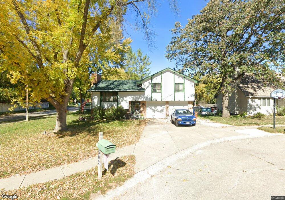
502 Phyllis Cir Bellevue, NE 68005
Estimated Value: $257,000 - $276,999
3
Beds
5
Baths
1,696
Sq Ft
$157/Sq Ft
Est. Value
About This Home
This home is located at 502 Phyllis Cir, Bellevue, NE 68005 and is currently estimated at $266,750, approximately $157 per square foot. 502 Phyllis Cir is a home located in Sarpy County with nearby schools including Bertha Barber Elementary School, Bellevue Mission Middle School, and Bellevue East High School.
Ownership History
Date
Name
Owned For
Owner Type
Purchase Details
Closed on
May 18, 1999
Sold by
Wheeler Dorothea H
Bought by
Jewell Timothy M and Jewell Laura R
Current Estimated Value
Home Financials for this Owner
Home Financials are based on the most recent Mortgage that was taken out on this home.
Original Mortgage
$107,373
Outstanding Balance
$27,445
Interest Rate
6.91%
Estimated Equity
$239,305
Create a Home Valuation Report for This Property
The Home Valuation Report is an in-depth analysis detailing your home's value as well as a comparison with similar homes in the area
Home Values in the Area
Average Home Value in this Area
Purchase History
| Date | Buyer | Sale Price | Title Company |
|---|---|---|---|
| Jewell Timothy M | $105,000 | -- |
Source: Public Records
Mortgage History
| Date | Status | Borrower | Loan Amount |
|---|---|---|---|
| Open | Jewell Timothy M | $107,373 |
Source: Public Records
Tax History Compared to Growth
Tax History
| Year | Tax Paid | Tax Assessment Tax Assessment Total Assessment is a certain percentage of the fair market value that is determined by local assessors to be the total taxable value of land and additions on the property. | Land | Improvement |
|---|---|---|---|---|
| 2025 | $3,762 | $233,831 | $43,000 | $190,831 |
| 2024 | $4,330 | $216,672 | $39,000 | $177,672 |
| 2023 | $4,330 | $205,081 | $36,000 | $169,081 |
| 2022 | $3,724 | $173,054 | $31,000 | $142,054 |
| 2021 | $3,488 | $160,370 | $28,000 | $132,370 |
| 2020 | $3,417 | $156,601 | $28,000 | $128,601 |
| 2019 | $3,160 | $145,698 | $26,000 | $119,698 |
| 2018 | $2,935 | $139,003 | $26,000 | $113,003 |
| 2017 | $2,840 | $133,586 | $26,000 | $107,586 |
| 2016 | $2,689 | $129,269 | $26,000 | $103,269 |
| 2015 | $2,666 | $128,888 | $26,000 | $102,888 |
| 2014 | $2,656 | $127,610 | $26,000 | $101,610 |
| 2012 | -- | $125,818 | $26,000 | $99,818 |
Source: Public Records
Map
Nearby Homes
- 1601 Main St
- 1807 Warren St
- 1801 Franklin St
- 1322 Hancock St
- 2232 Wilson Dr
- 2111 Washington St
- 2504 Main St
- 2507 Hancock St
- 2510 Hancock St
- 2519 Hancock St
- Lot 13 Hidden Hills Dr
- 1007 Normandy Dr
- 2503 Wayne St
- 706 W Mission Ave
- 2512 Washington St
- 910 Lemay Dr
- 2709 Franklin St
- 101 E 28th Ave
- 1306 Lincoln Rd
- 1110 Potter Rd
- 504 Phyllis Cir
- 411 E 16th Ave
- 1511 Bluff St Unit 1513
- 1511 Bluff St
- 1609 Warren St
- 503 Phyllis Cir
- 410 E 16th Ave
- 1509 Bluff St
- 1610 Warren St
- 1611 Warren St
- 1510 Bluff St
- 1611 Warren St
- 401 E 16th Ave
- 1702 Warren St
- 1701 Warren St
- 1701 Warren St
- 1511 Warren St
- 1509 Warren St
- 1507 Warren St
- 1502 Bluff St