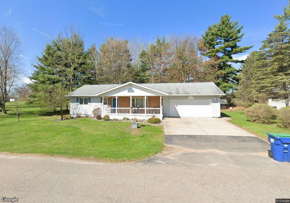
502 S 39th Ave Wausau, WI 54401
Estimated Value: $286,000 - $380,000
3
Beds
2
Baths
--
Sq Ft
0.94
Acres
About This Home
This home is located at 502 S 39th Ave, Wausau, WI 54401 and is currently estimated at $324,785. 502 S 39th Ave is a home located in Marathon County with nearby schools including Stettin Elementary School, John Muir Middle School, and West High School.
Ownership History
Date
Name
Owned For
Owner Type
Purchase Details
Closed on
Nov 18, 2005
Sold by
Paul Norbert C and Paul Helen M
Bought by
Gore Daniel C and Gore Janice K
Current Estimated Value
Home Financials for this Owner
Home Financials are based on the most recent Mortgage that was taken out on this home.
Original Mortgage
$124,000
Outstanding Balance
$68,315
Interest Rate
6.13%
Mortgage Type
New Conventional
Estimated Equity
$256,470
Purchase Details
Closed on
Jun 20, 2005
Sold by
Paul Norbert C and Paul Helen M
Bought by
Paul Norbert C and Paul Helen M
Create a Home Valuation Report for This Property
The Home Valuation Report is an in-depth analysis detailing your home's value as well as a comparison with similar homes in the area
Home Values in the Area
Average Home Value in this Area
Purchase History
| Date | Buyer | Sale Price | Title Company |
|---|---|---|---|
| Gore Daniel C | $155,000 | None Available | |
| Paul Norbert C | -- | None Available |
Source: Public Records
Mortgage History
| Date | Status | Borrower | Loan Amount |
|---|---|---|---|
| Open | Gore Daniel C | $124,000 |
Source: Public Records
Tax History Compared to Growth
Tax History
| Year | Tax Paid | Tax Assessment Tax Assessment Total Assessment is a certain percentage of the fair market value that is determined by local assessors to be the total taxable value of land and additions on the property. | Land | Improvement |
|---|---|---|---|---|
| 2024 | $4,741 | $259,500 | $64,400 | $195,100 |
| 2023 | $4,242 | $180,100 | $58,300 | $121,800 |
| 2022 | $4,275 | $180,100 | $58,300 | $121,800 |
| 2021 | $4,117 | $180,100 | $58,300 | $121,800 |
| 2020 | $4,273 | $180,100 | $58,300 | $121,800 |
| 2019 | $3,901 | $155,500 | $46,100 | $109,400 |
| 2018 | $4,055 | $155,500 | $46,100 | $109,400 |
| 2017 | $3,780 | $155,500 | $46,100 | $109,400 |
| 2016 | $3,665 | $155,500 | $46,100 | $109,400 |
| 2015 | $3,902 | $155,500 | $46,100 | $109,400 |
| 2014 | $4,010 | $167,700 | $50,500 | $117,200 |
Source: Public Records
Map
Nearby Homes
- 310 Lisbeth Rd
- 210 S 45th Ave
- 206 N 44th Ave
- 3401 Christian Ave
- 4615 Rib River Trail
- 2812 Hubbill Ave
- 2102 Wegner St
- 5713 Birchwood Dr
- 210 Bluestone Dr
- 2117 Sherman St
- 303 Rimrock Rd
- 6007 Birchwood Dr
- 212 Windtree Dr
- 1708 Pardee St
- 227815 Sharptail Rd
- 213 N 17th Ave
- 6011 Stettin Dr
- 931 S 14th Ave
- 6603 Conner Davis Dr
- 6607 Morgan Creek Dr
- 418 S 39th Ave
- 510 S 39th Ave
- 505 S 39th Ave
- 511 S 39th Ave
- 417 S 39th Ave
- 412 S 39th Ave
- 517 S 39th Ave
- 411 S 39th Ave
- 600 S 39th Ave
- 601 S 39th Ave
- 321 S 39th Ave
- 320 S 39th Ave
- 311 S 39th Ave
- 312 S 39th Ave
- 3907 Tanglewood Ln
- 305 S 39th Ave
- 3820 Stewart Ave
- 3808 Stewart Ave
- 515 S 38th Ave
- 4002 Stewart Ave