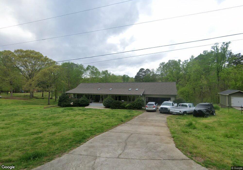
5026 Old Mulberry Rd Flowery Branch, GA 30542
Estimated Value: $453,000 - $576,000
4
Beds
3
Baths
2,274
Sq Ft
$221/Sq Ft
Est. Value
About This Home
This home is located at 5026 Old Mulberry Rd, Flowery Branch, GA 30542 and is currently estimated at $502,381, approximately $220 per square foot. 5026 Old Mulberry Rd is a home located in Hall County with nearby schools including Chestnut Mountain Elementary School, Cherokee Bluff Middle School, and Cherokee Bluff High School.
Ownership History
Date
Name
Owned For
Owner Type
Purchase Details
Closed on
Mar 2, 2012
Sold by
Markey Michael P
Bought by
Sanford Elisa A and Lopiccolo Joseph Ne
Current Estimated Value
Purchase Details
Closed on
May 19, 2011
Sold by
First Horizon Hm Ln
Bought by
Markey Michael P and Sanford Elisa
Purchase Details
Closed on
Feb 1, 2011
Sold by
Kaminski Elizabeth
Bought by
First Horizon Hm Ln
Purchase Details
Closed on
Mar 1, 1995
Create a Home Valuation Report for This Property
The Home Valuation Report is an in-depth analysis detailing your home's value as well as a comparison with similar homes in the area
Home Values in the Area
Average Home Value in this Area
Purchase History
| Date | Buyer | Sale Price | Title Company |
|---|---|---|---|
| Sanford Elisa A | -- | -- | |
| Markey Michael P | $170,000 | -- | |
| First Horizon Hm Ln | $228,000 | -- | |
| -- | $12,500 | -- |
Source: Public Records
Tax History Compared to Growth
Tax History
| Year | Tax Paid | Tax Assessment Tax Assessment Total Assessment is a certain percentage of the fair market value that is determined by local assessors to be the total taxable value of land and additions on the property. | Land | Improvement |
|---|---|---|---|---|
| 2024 | $3,863 | $153,560 | $33,640 | $119,920 |
| 2023 | $3,622 | $143,760 | $15,840 | $127,920 |
| 2022 | $2,663 | $100,600 | $11,680 | $88,920 |
| 2021 | $2,631 | $97,520 | $11,680 | $85,840 |
| 2020 | $2,548 | $91,600 | $9,360 | $82,240 |
| 2019 | $2,452 | $87,280 | $9,360 | $77,920 |
| 2018 | $2,406 | $82,800 | $9,360 | $73,440 |
| 2017 | $2,222 | $77,080 | $9,360 | $67,720 |
| 2016 | $2,072 | $73,520 | $7,960 | $65,560 |
| 2015 | $2,089 | $73,520 | $7,960 | $65,560 |
| 2014 | $2,089 | $73,520 | $7,960 | $65,560 |
Source: Public Records
Map
Nearby Homes
- 5273 Mulberry Creek Way
- 5273 Mulberry Creek Way Unit LOT 77
- 5277 Mulberry Creek Way
- 5277 Mulberry Creek Way Unit LOT 78
- 5305 Mulberry Creek Way Unit LOT 79
- 5305 Mulberry Creek Way
- 5432 Aurora Trail Unit LOT 70
- 5428 Aurora Trail
- 5428 Aurora Trail Unit LOT 71
- 5427 Aurora Trail Unit LOT 65
- 5436 Aurora Trail
- 5416 Aurora Trail Unit LOT 74
- 5412 Aurora Trail Unit LOT 75
- 5427 Aurora Trail
- 5435 Aurora Trail
- 5432 Aurora Trail
- 5412 Aurora Trail
- 5424 Aurora Trail Unit LOT 72
- 5431 Aurora Trail
- 5416 Aurora Trail
- 5042 Old Mulberry Rd
- 5024 Union Church Rd
- 5014 Old Mulberry Rd
- 5018 Union Church Rd
- 5008 Union Church Rd
- 5015 Union Church Rd
- 5025 Union Church Rd
- 5013 Union Church Rd
- 5009 Union Church Rd
- 5031 Union Church Rd
- 4992 Union Church Rd Unit 1
- 4992 Union Church Rd
- 4995 Union Church Rd
- 5036 Union Church Rd
- 5012 Oak Farm Way
- 5022 Oak Farm Way
- 5057 Old Mulberry Rd
- 4984 Union Church Rd Unit 2
- 4984 Union Church Rd
- 5030 Oak Farm Way