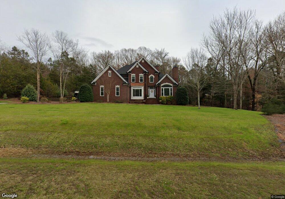
5029 Crofton Dr Fort Mill, SC 29715
Estimated Value: $768,000 - $922,000
--
Bed
1
Bath
3,179
Sq Ft
$261/Sq Ft
Est. Value
About This Home
This home is located at 5029 Crofton Dr, Fort Mill, SC 29715 and is currently estimated at $829,717, approximately $260 per square foot. 5029 Crofton Dr is a home with nearby schools including Doby's Bridge Elementary School and Catawba Ridge High School.
Ownership History
Date
Name
Owned For
Owner Type
Purchase Details
Closed on
May 30, 2006
Sold by
Allen Carla A and Allen Thomas P
Bought by
Beebe John A and Beebe Annamarie
Current Estimated Value
Home Financials for this Owner
Home Financials are based on the most recent Mortgage that was taken out on this home.
Original Mortgage
$305,000
Interest Rate
6.6%
Mortgage Type
New Conventional
Purchase Details
Closed on
Dec 8, 2003
Sold by
C Douglas Shore & Co Inc
Bought by
Allen Thomas P and Allen Carla A
Purchase Details
Closed on
Jun 12, 2002
Sold by
The Penton Group Inc
Bought by
C Douglas Shore & Company Inc
Create a Home Valuation Report for This Property
The Home Valuation Report is an in-depth analysis detailing your home's value as well as a comparison with similar homes in the area
Home Values in the Area
Average Home Value in this Area
Purchase History
| Date | Buyer | Sale Price | Title Company |
|---|---|---|---|
| Beebe John A | $440,000 | None Available | |
| Allen Thomas P | $389,900 | -- | |
| C Douglas Shore & Company Inc | $51,000 | -- |
Source: Public Records
Mortgage History
| Date | Status | Borrower | Loan Amount |
|---|---|---|---|
| Previous Owner | Beebe John A | $305,000 |
Source: Public Records
Tax History Compared to Growth
Tax History
| Year | Tax Paid | Tax Assessment Tax Assessment Total Assessment is a certain percentage of the fair market value that is determined by local assessors to be the total taxable value of land and additions on the property. | Land | Improvement |
|---|---|---|---|---|
| 2024 | $2,796 | $16,790 | $4,195 | $12,595 |
| 2023 | $2,705 | $16,790 | $4,195 | $12,595 |
| 2022 | $2,680 | $16,790 | $4,195 | $12,595 |
| 2021 | -- | $16,790 | $4,195 | $12,595 |
| 2020 | $2,890 | $16,790 | $0 | $0 |
| 2019 | $2,907 | $14,600 | $0 | $0 |
| 2018 | $3,084 | $14,600 | $0 | $0 |
| 2017 | $2,914 | $14,600 | $0 | $0 |
| 2016 | $2,897 | $14,600 | $0 | $0 |
| 2014 | $2,212 | $14,600 | $3,200 | $11,400 |
| 2013 | $2,212 | $15,980 | $3,800 | $12,180 |
Source: Public Records
Map
Nearby Homes
- 1026 Arges River Dr
- 831 Tyne Dr
- 837 Tyne Dr
- 4071 Thames Cir
- 429 Hendon Row Way
- 1281 Arges River Dr
- 4201 Thames Cir
- 1227 Cabin Creek Ct
- 1042 Croyden Ct
- 1427 Doe Ridge Ln
- 1737 Felts Pkwy
- 1761 Felts Pkwy
- 1098 Kings Bottom Dr
- 1786 Felts Pkwy
- 5009 Saint Clair St
- 1012 Kings Bottom Dr
- 2760 Holbrook Rd
- 273 Monteray Oaks Cir
- 749 Pela Vista Ct
- lot 5 Holbrook Rd Unit 5
- 5037 Crofton Dr
- 5032 Crofton Dr
- 5020 Crofton Dr
- 5041 Crofton Dr
- 712 Mayfield Ct
- 708 Mayfield Ct
- 716 Mayfield Ct
- 704 Mayfield Ct
- 5045 Crofton Dr
- 720 Mayfield Ct
- 5016 Crofton Dr
- 1710 Brookshaw Run
- 1714 Brookshaw Run
- 5049 Crofton Dr
- 5044 Crofton Dr
- 711 Mayfield Ct
- 699 Penny Royal Ave
- 715 Mayfield Ct
- 1411 Hoxton Ct
- 705 Penny Royal Ave