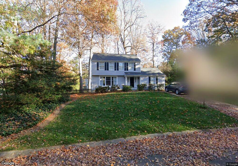
503 Burning Tree Dr Arnold, MD 21012
Estimated Value: $596,165 - $737,000
Studio
3
Baths
2,432
Sq Ft
$279/Sq Ft
Est. Value
About This Home
This home is located at 503 Burning Tree Dr, Arnold, MD 21012 and is currently estimated at $679,291, approximately $279 per square foot. 503 Burning Tree Dr is a home located in Anne Arundel County with nearby schools including Broadneck Elementary School, Magothy River Middle School, and Broadneck High School.
Ownership History
Date
Name
Owned For
Owner Type
Purchase Details
Closed on
Aug 24, 1988
Sold by
Pesaturo John F
Bought by
Freitag Michael L and Freitag Linda L
Current Estimated Value
Home Financials for this Owner
Home Financials are based on the most recent Mortgage that was taken out on this home.
Original Mortgage
$120,000
Interest Rate
10.71%
Create a Home Valuation Report for This Property
The Home Valuation Report is an in-depth analysis detailing your home's value as well as a comparison with similar homes in the area
Home Values in the Area
Average Home Value in this Area
Purchase History
| Date | Buyer | Sale Price | Title Company |
|---|---|---|---|
| Freitag Michael L | $150,000 | -- |
Source: Public Records
Mortgage History
| Date | Status | Borrower | Loan Amount |
|---|---|---|---|
| Closed | Freitag Michael L | $120,000 |
Source: Public Records
Tax History
| Year | Tax Paid | Tax Assessment Tax Assessment Total Assessment is a certain percentage of the fair market value that is determined by local assessors to be the total taxable value of land and additions on the property. | Land | Improvement |
|---|---|---|---|---|
| 2025 | $3,909 | $490,367 | -- | -- |
| 2024 | $3,909 | $462,600 | $265,500 | $197,100 |
| 2023 | $3,812 | $459,833 | $0 | $0 |
| 2022 | $3,577 | $457,067 | $0 | $0 |
| 2020 | $3,404 | $430,233 | $0 | $0 |
| 2019 | $3,330 | $406,167 | $0 | $0 |
| 2018 | $3,874 | $382,100 | $225,500 | $156,600 |
| 2017 | $3,127 | $378,533 | $0 | $0 |
| 2016 | -- | $374,967 | $0 | $0 |
| 2015 | -- | $371,400 | $0 | $0 |
| 2014 | -- | $367,700 | $0 | $0 |
Source: Public Records
Map
Nearby Homes
- 1410 Greendale Ct Unit 2-1410
- 618 Newbridge Ct Unit 3-618
- 656 Newbridge Ct Unit 4-656
- 1221 Seminole Dr
- 624 Southern Hills Dr Unit B-2A
- 628 Southern Hills Dr Unit B-2C
- 1411 Peregrine Path
- 1124 Brassie Ct
- 570 Quaker Ridge Ct
- 1110 Niblick Ct
- 592 Quaker Ridge Ct
- 402 Duck Bill Ln
- 508 Bay Hills Dr
- 1467 Eagle Ct
- 975 Phillips Dr
- 1254 Masters Dr
- 876 Shore Acres Rd
- 1266 Seabright Dr
- 721 Fairway Dr
- 1553 Star Pine Dr
- 505 Burning Tree Dr
- 501 Burning Tree Dr
- 500 Golf Cir
- 501 Golf Cir
- 517 Augusta Dr
- 500 Burning Tree Dr
- 502 Burning Tree Dr
- 507 Burning Tree Dr
- 519 Augusta Dr
- 503 Golf Cir
- 1243 Gloria Harris Ct
- 502 Golf Cir
- 511 Augusta Dr
- 521 Augusta Dr
- 509 Burning Tree Dr
- 504 Burning Tree Cir
- 516 Augusta Dr
- 514 Augusta Dr
- 554 Bay Green Dr
- 546 Bay Green Dr
Your Personal Tour Guide
Ask me questions while you tour the home.