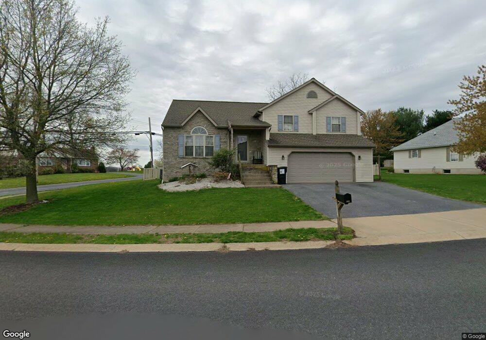
503 High Point Dr Denver, PA 17517
Estimated Value: $356,092 - $428,000
3
Beds
2
Baths
1,369
Sq Ft
$281/Sq Ft
Est. Value
About This Home
This home is located at 503 High Point Dr, Denver, PA 17517 and is currently estimated at $384,773, approximately $281 per square foot. 503 High Point Dr is a home located in Lancaster County with nearby schools including Garden Spot Middle School, Garden Spot Senior High School, and Muddy Creek Christian School.
Ownership History
Date
Name
Owned For
Owner Type
Purchase Details
Closed on
Nov 30, 2001
Sold by
Hartman Robert A and Hartman Amy M
Bought by
Reiff Gregory C and Reiff Krista Y
Current Estimated Value
Home Financials for this Owner
Home Financials are based on the most recent Mortgage that was taken out on this home.
Original Mortgage
$124,000
Outstanding Balance
$48,777
Interest Rate
6.66%
Estimated Equity
$335,996
Purchase Details
Closed on
Dec 8, 2000
Sold by
Kimmet W Todd
Bought by
Hartman Robert A and Hartman Amy M
Home Financials for this Owner
Home Financials are based on the most recent Mortgage that was taken out on this home.
Original Mortgage
$117,200
Interest Rate
7.64%
Create a Home Valuation Report for This Property
The Home Valuation Report is an in-depth analysis detailing your home's value as well as a comparison with similar homes in the area
Home Values in the Area
Average Home Value in this Area
Purchase History
| Date | Buyer | Sale Price | Title Company |
|---|---|---|---|
| Reiff Gregory C | $155,000 | First American Title Ins Co | |
| Hartman Robert A | $146,500 | -- |
Source: Public Records
Mortgage History
| Date | Status | Borrower | Loan Amount |
|---|---|---|---|
| Open | Reiff Gregory C | $124,000 | |
| Previous Owner | Hartman Robert A | $117,200 | |
| Closed | Reiff Gregory C | $23,250 |
Source: Public Records
Tax History Compared to Growth
Tax History
| Year | Tax Paid | Tax Assessment Tax Assessment Total Assessment is a certain percentage of the fair market value that is determined by local assessors to be the total taxable value of land and additions on the property. | Land | Improvement |
|---|---|---|---|---|
| 2025 | $3,201 | $186,000 | $46,800 | $139,200 |
| 2024 | $3,201 | $186,000 | $46,800 | $139,200 |
| 2023 | $3,135 | $186,000 | $46,800 | $139,200 |
| 2022 | $3,082 | $186,000 | $46,800 | $139,200 |
| 2021 | $2,927 | $186,000 | $46,800 | $139,200 |
| 2020 | $2,927 | $186,000 | $46,800 | $139,200 |
| 2019 | $2,893 | $186,000 | $46,800 | $139,200 |
| 2018 | $4,479 | $186,000 | $46,800 | $139,200 |
| 2017 | $2,782 | $146,100 | $34,700 | $111,400 |
| 2016 | $2,782 | $146,100 | $34,700 | $111,400 |
| 2015 | $585 | $146,100 | $34,700 | $111,400 |
| 2014 | $2,041 | $146,100 | $34,700 | $111,400 |
Source: Public Records
Map
Nearby Homes
- 534 High Point Dr
- 602 Greenview Dr
- 111 Oatfield Dr
- 117 Hawk Valley Ln Unit 105
- 101 Hawk Valley Ln
- Bridgemont Plan at Hawk Valley Estates
- Sullivan Plan at Hawk Valley Estates
- Silverbrooke Plan at Hawk Valley Estates
- Wesley Plan at Hawk Valley Estates
- Kingston Plan at Hawk Valley Estates
- Logan Plan at Hawk Valley Estates
- Brookfield Plan at Hawk Valley Estates
- Westbrooke Plan at Hawk Valley Estates
- Berkley Plan at Hawk Valley Estates
- Callahan Plan at Hawk Valley Estates
- 55 Hawk Valley Ln
- 01 W Valley Rd
- 346 Aplomado St
- 32 Hawk Valley Ln
- 256 W Valley Rd
- 507 High Point Dr
- 500 High Point Dr
- 529 W Maple Grove Rd
- 1100 Village Cir
- 534 W Maple Grove Rd
- 511 High Point Dr
- 1101 Village Cir
- 1104 Village Cir
- 538 W Maple Grove Rd
- 516 High Point Dr
- 515 High Point Dr
- 1105 Village Cir
- 520 W Maple Grove Rd
- 1108 Village Cir
- 542 W Maple Grove Rd
- 541 W Maple Grove Rd
- 526 High Point Dr
- 519 High Point Dr
- 546 W Maple Grove Rd
- 1113 Village Cir