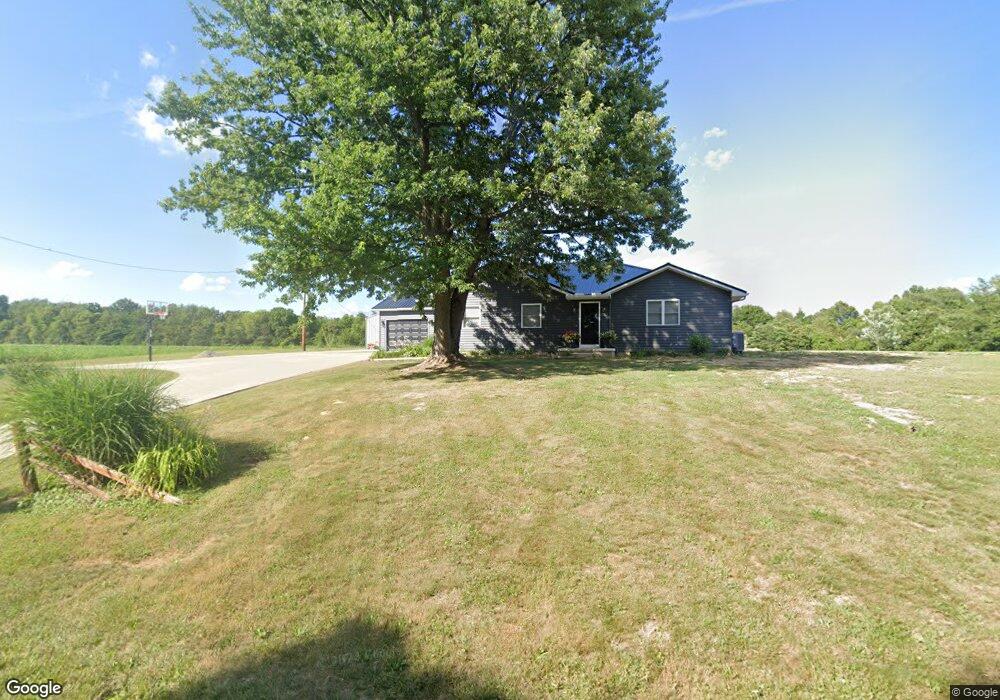
503 Hurless Rd Frankfort, OH 45628
Estimated Value: $212,778 - $277,000
3
Beds
1
Bath
1,086
Sq Ft
$213/Sq Ft
Est. Value
About This Home
This home is located at 503 Hurless Rd, Frankfort, OH 45628 and is currently estimated at $231,445, approximately $213 per square foot. 503 Hurless Rd is a home located in Ross County with nearby schools including Paint Valley Elementary School, Paint Valley Middle School, and Paint Valley High School.
Ownership History
Date
Name
Owned For
Owner Type
Purchase Details
Closed on
Oct 26, 2016
Sold by
Green Ruth E and Green James H
Bought by
Chaney Logan A and Stanforth Laci A
Current Estimated Value
Home Financials for this Owner
Home Financials are based on the most recent Mortgage that was taken out on this home.
Original Mortgage
$90,250
Outstanding Balance
$72,637
Interest Rate
3.5%
Mortgage Type
Purchase Money Mortgage
Estimated Equity
$158,808
Create a Home Valuation Report for This Property
The Home Valuation Report is an in-depth analysis detailing your home's value as well as a comparison with similar homes in the area
Home Values in the Area
Average Home Value in this Area
Purchase History
| Date | Buyer | Sale Price | Title Company |
|---|---|---|---|
| Chaney Logan A | $95,000 | Lcnb Title Services |
Source: Public Records
Mortgage History
| Date | Status | Borrower | Loan Amount |
|---|---|---|---|
| Open | Chaney Logan A | $90,250 |
Source: Public Records
Tax History Compared to Growth
Tax History
| Year | Tax Paid | Tax Assessment Tax Assessment Total Assessment is a certain percentage of the fair market value that is determined by local assessors to be the total taxable value of land and additions on the property. | Land | Improvement |
|---|---|---|---|---|
| 2024 | $1,670 | $47,420 | $5,470 | $41,950 |
| 2023 | $1,670 | $47,420 | $5,470 | $41,950 |
| 2022 | $1,635 | $47,420 | $5,470 | $41,950 |
| 2021 | $1,496 | $40,530 | $3,850 | $36,680 |
| 2020 | $1,494 | $40,530 | $3,850 | $36,680 |
| 2019 | $1,261 | $33,690 | $3,850 | $29,840 |
| 2018 | $1,055 | $27,450 | $3,430 | $24,020 |
| 2017 | $1,033 | $26,830 | $3,430 | $23,400 |
| 2016 | $1,032 | $26,830 | $3,430 | $23,400 |
| 2015 | $1,076 | $27,940 | $3,430 | $24,510 |
| 2014 | -- | $27,940 | $3,430 | $24,510 |
| 2013 | $1,069 | $27,940 | $3,430 | $24,510 |
Source: Public Records
Map
Nearby Homes
- 5678 Lower Twin Rd
- 10830 Lower Twin Rd
- 2139 Poplar Ridge Rd
- 10605 State Route 28
- 10792 State Route 28
- 0 State Route 28
- 7535 State Route 28
- 10597 State Route 28
- 0 N Sd Rt 28
- 0 N Sd St Rt 28
- 0 N Sd Rt 28 Unit 225026807
- 2371 Owl Creek Rd
- 235 Lagerham Ln
- 7885 Upper Twin Rd
- 2946 Wisecup Hill Rd
- 2025 Little Creek Rd
- 11511 Taylor St
- 0 Upper Twin Rd Unit 5159777
- 0 Upper Twin Rd Unit 225036418
- 4945 Upper Twin Rd
- 605 Hurless Rd
- 755 Hurless Rd
- 707 Hurless Rd
- 0 Hurless Rd
- 1344 McDonald Hill Rd
- 1167 McDonald Hill Rd
- 1536 McDonald Hill Rd
- 638 McDonald Hill Rd
- 638 Mc Donald Hill Rd
- 1598 McDonald Hill Rd
- 0 Mc Donald Hill Rd
- 000 Mc Donald Hill Rd
- 0 Mingo (Hurless Road) Rd
- 1386 Poplar Ridge Rd
- 1745 McDonald Hill Rd
- 452 McDonald Hill Rd
- 613 Poplar Ridge Rd
- 494 Poplar Ridge Rd
- 1424 Poplar Ridge Rd
- 355 Mingo Rd