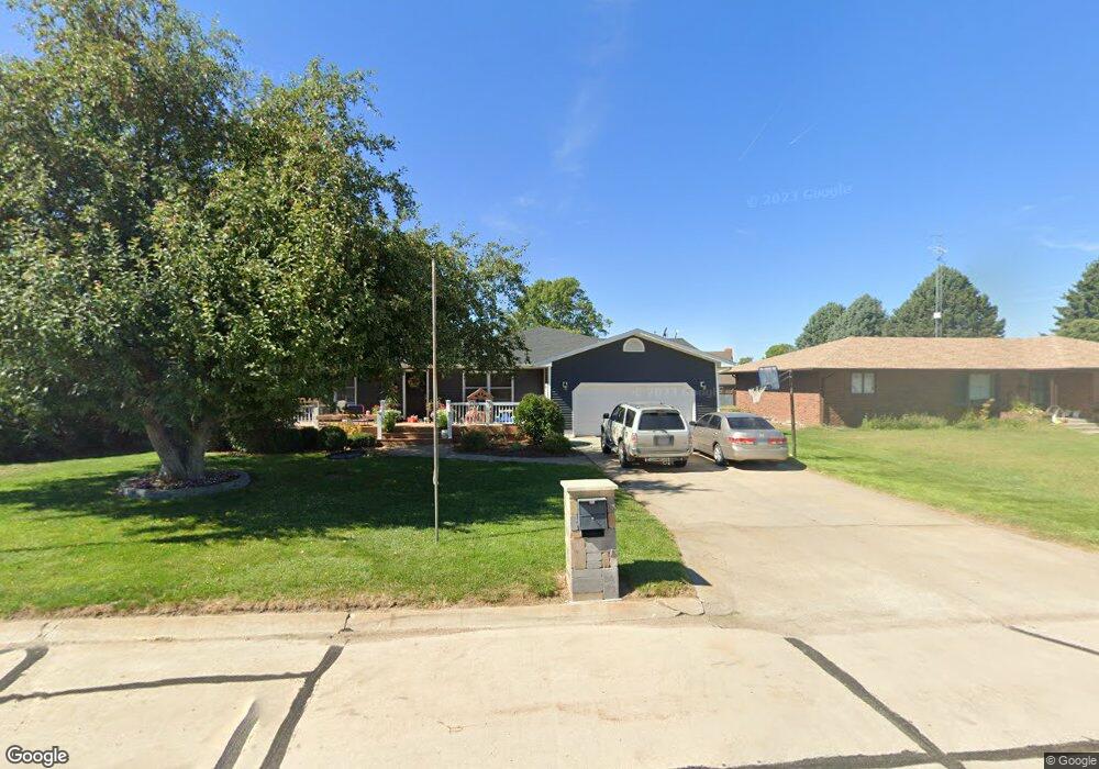
503 N Wright St Eustis, NE 69028
Estimated Value: $286,042 - $494,000
4
Beds
3
Baths
2,160
Sq Ft
$167/Sq Ft
Est. Value
About This Home
This home is located at 503 N Wright St, Eustis, NE 69028 and is currently estimated at $360,761, approximately $167 per square foot. 503 N Wright St is a home located in Frontier County with nearby schools including Elementary School at Eustis and Eustis-Farnam High School.
Ownership History
Date
Name
Owned For
Owner Type
Purchase Details
Closed on
Sep 11, 2020
Sold by
Malcom David D and Malcom Marilee
Bought by
Arends Courtney A and Arends Brant R
Current Estimated Value
Home Financials for this Owner
Home Financials are based on the most recent Mortgage that was taken out on this home.
Original Mortgage
$177,200
Outstanding Balance
$157,253
Interest Rate
2.9%
Mortgage Type
New Conventional
Estimated Equity
$203,508
Create a Home Valuation Report for This Property
The Home Valuation Report is an in-depth analysis detailing your home's value as well as a comparison with similar homes in the area
Purchase History
| Date | Buyer | Sale Price | Title Company |
|---|---|---|---|
| Arends Courtney A | $225,000 | None Available |
Source: Public Records
Mortgage History
| Date | Status | Borrower | Loan Amount |
|---|---|---|---|
| Open | Arends Courtney A | $177,200 |
Source: Public Records
Tax History
| Year | Tax Paid | Tax Assessment Tax Assessment Total Assessment is a certain percentage of the fair market value that is determined by local assessors to be the total taxable value of land and additions on the property. | Land | Improvement |
|---|---|---|---|---|
| 2025 | $2,771 | $276,545 | $15,760 | $260,785 |
| 2024 | $3,618 | $276,545 | $15,760 | $260,785 |
| 2023 | $3,022 | $258,484 | $7,880 | $250,604 |
| 2022 | $3,022 | $218,962 | $7,880 | $211,082 |
| 2021 | $2,744 | $218,962 | $7,880 | $211,082 |
| 2020 | $1,912 | $152,692 | $3,680 | $149,012 |
| 2019 | $1,838 | $152,692 | $3,680 | $149,012 |
| 2018 | $1,805 | $152,692 | $3,680 | $149,012 |
| 2017 | $1,740 | $152,692 | $3,680 | $149,012 |
| 2016 | $1,450 | $122,591 | $5,240 | $117,351 |
| 2015 | $1,459 | $122,591 | $5,240 | $117,351 |
| 2014 | $1,535 | $111,931 | $5,240 | $106,691 |
Source: Public Records
Map
Nearby Homes
- 502 W Hendricks St
- 602 W Cameron
- 406 N Clay St
- 406 N Hamilton St
- 4 W Plum Creek Canyon Uebele
- 0 Rd 775 & Hwy 21 Hwy Unit 22606175
- 16 Burkholder Dr
- Lot 1 Reddington Farms Subdivision
- Lot 13 Reddington Farms Subdivision
- Lot 2 Reddington Farms Subdivision
- Lot 12 Reddington Farms Subdivision
- Lot 16 Reddington Farms Subdivision
- Lot 14 Reddington Farms Subdivision
- Lot 3 Reddington Farms Subdivision
- Lot 11 Reddington Farms Subdivision
- Lot 6 Reddington Farms Subdivision
- Lot 15 Reddington Farms Subdivision
- Lot 5 Reddington Farms Subdivision
- Lot 8 Reddington Farms Subdivision
- Lot 4 Reddington Farms Subdivision
- 501 N Wright St
- 505 N Wright St
- 102 Johnson Place
- 600 Johnson Place
- 100 Johnson Place
- 507 N Wright St
- 504 N Wright St
- 502 N Wright St
- 500 N Wright St
- 104 Johnson Place
- 605 W Hendricks St
- 504 W Hendricks St
- 601 W Hendricks St
- 101 Johnson Place
- 607 W Hendricks St
- 103 Johnson Place
- 404 N Wright St Unit 406
- 403 N Wright St
- 608 W Cameron St
- 402 N Wright St
Your Personal Tour Guide
Ask me questions while you tour the home.