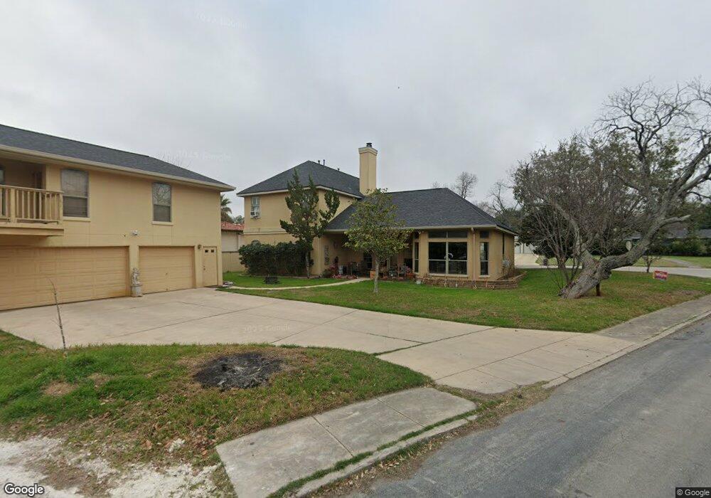
503 Oakleaf Dr San Antonio, TX 78209
Oak Park-Northwood NeighborhoodEstimated Value: $533,000 - $741,000
4
Beds
3
Baths
2,828
Sq Ft
$234/Sq Ft
Est. Value
About This Home
This home is located at 503 Oakleaf Dr, San Antonio, TX 78209 and is currently estimated at $661,063, approximately $233 per square foot. 503 Oakleaf Dr is a home located in Bexar County with nearby schools including Northwood Elementary School, Garner Middle School, and MacArthur High School.
Ownership History
Date
Name
Owned For
Owner Type
Purchase Details
Closed on
Dec 30, 2009
Sold by
Stitt Fraser and Estate Of Donald Fraser Stitt
Bought by
Stitt William Taylor and Stitt Fraser
Current Estimated Value
Purchase Details
Closed on
Sep 17, 2001
Sold by
Dysart Sara E
Bought by
Stitt Donnie and Stitt Fraser
Create a Home Valuation Report for This Property
The Home Valuation Report is an in-depth analysis detailing your home's value as well as a comparison with similar homes in the area
Home Values in the Area
Average Home Value in this Area
Purchase History
| Date | Buyer | Sale Price | Title Company |
|---|---|---|---|
| Stitt William Taylor | -- | None Available | |
| Stitt Donnie | -- | Alamo Title |
Source: Public Records
Tax History Compared to Growth
Tax History
| Year | Tax Paid | Tax Assessment Tax Assessment Total Assessment is a certain percentage of the fair market value that is determined by local assessors to be the total taxable value of land and additions on the property. | Land | Improvement |
|---|---|---|---|---|
| 2025 | $10,153 | $662,000 | $163,320 | $498,680 |
| 2024 | $10,153 | $662,000 | $163,320 | $498,680 |
| 2023 | $10,269 | $640,000 | $163,320 | $476,680 |
| 2022 | $12,726 | $625,000 | $142,010 | $482,990 |
| 2021 | $12,819 | $590,440 | $123,540 | $466,900 |
| 2020 | $14,056 | $542,000 | $109,640 | $432,360 |
| 2019 | $14,382 | $540,000 | $109,640 | $430,360 |
| 2018 | $14,205 | $532,000 | $87,710 | $444,290 |
| 2017 | $14,121 | $524,000 | $87,710 | $436,290 |
| 2016 | $13,474 | $500,000 | $52,690 | $447,310 |
| 2015 | $9,225 | $489,179 | $52,690 | $475,110 |
| 2014 | $9,225 | $444,708 | $0 | $0 |
Source: Public Records
Map
Nearby Homes
- 510 Burnside Dr
- 510 Woodcrest Dr
- 530 Burnside Dr
- 419 Woodcrest Dr
- 351 Northridge Dr
- 2603 Brookhurst Dr
- 318 Northridge Dr
- 315 Tophill Rd
- 623 E Nottingham Dr
- 446 Forrest Hill Dr
- 215 Oakleaf Dr
- 631 Robinhood Place
- 134 Rockhill Dr
- 7606 N Vandiver Rd
- 411 Cave Ln
- 205 Larkwood Dr
- 210 Laramie Dr
- 215 Tophill Rd
- 7238 Seidel Rd
- 2434 Toftrees Dr
- 507 Oakleaf Dr
- 502 Burnside Dr
- 447 Oakleaf Dr
- 515 Oakleaf Dr
- 506 Oakleaf Dr
- 450 Burnside Dr
- 502 Oakleaf Dr
- 510 Oakleaf Dr
- 506 Burnside Dr
- 443 Oakleaf Dr
- 519 Oakleaf Dr
- 514 Oakleaf Dr
- 442 Burnside Dr
- 442 Oakleaf Dr
- 439 Oakleaf Dr
- 455 Burnside Dr
- 518 Oakleaf Dr
- 451 Burnside Dr
- 515 Woodcrest Dr
- 523 Oakleaf Dr