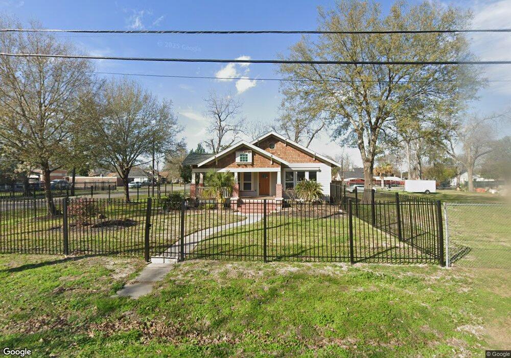
503 Westford St Houston, TX 77022
Northside-Northline NeighborhoodEstimated Value: $269,000 - $653,000
2
Beds
2
Baths
1,484
Sq Ft
$345/Sq Ft
Est. Value
About This Home
This home is located at 503 Westford St, Houston, TX 77022 and is currently estimated at $512,700, approximately $345 per square foot. 503 Westford St is a home located in Harris County with nearby schools including Herrera Elementary School, Burbank Middle School, and Sam Houston Math, Science & Technology Center.
Ownership History
Date
Name
Owned For
Owner Type
Purchase Details
Closed on
Sep 9, 2010
Sold by
Campa Mateo and Campa Francisco
Bought by
Veazey Asset Holdings Llc
Current Estimated Value
Purchase Details
Closed on
Sep 22, 2009
Sold by
Neiman Elizabeth Robinson
Bought by
Campa Mateo and Campa Francisco
Home Financials for this Owner
Home Financials are based on the most recent Mortgage that was taken out on this home.
Original Mortgage
$158,000
Interest Rate
5.36%
Mortgage Type
Seller Take Back
Create a Home Valuation Report for This Property
The Home Valuation Report is an in-depth analysis detailing your home's value as well as a comparison with similar homes in the area
Home Values in the Area
Average Home Value in this Area
Purchase History
| Date | Buyer | Sale Price | Title Company |
|---|---|---|---|
| Veazey Asset Holdings Llc | -- | Fidelity National Title | |
| Campa Mateo | -- | None Available |
Source: Public Records
Mortgage History
| Date | Status | Borrower | Loan Amount |
|---|---|---|---|
| Previous Owner | Campa Mateo | $158,000 |
Source: Public Records
Tax History Compared to Growth
Tax History
| Year | Tax Paid | Tax Assessment Tax Assessment Total Assessment is a certain percentage of the fair market value that is determined by local assessors to be the total taxable value of land and additions on the property. | Land | Improvement |
|---|---|---|---|---|
| 2025 | $15,559 | $732,654 | $594,575 | $138,079 |
| 2024 | $15,559 | $743,606 | $594,575 | $149,031 |
| 2023 | $15,559 | $682,514 | $515,881 | $166,633 |
| 2022 | $11,846 | $538,000 | $384,725 | $153,275 |
| 2021 | $11,350 | $487,000 | $384,725 | $102,275 |
| 2020 | $11,155 | $460,656 | $384,725 | $75,931 |
| 2019 | $10,685 | $422,241 | $314,775 | $107,466 |
| 2018 | $7,313 | $289,000 | $218,594 | $70,406 |
| 2017 | $7,308 | $289,000 | $218,594 | $70,406 |
| 2016 | $7,625 | $301,574 | $218,594 | $82,980 |
| 2015 | $5,200 | $275,884 | $174,875 | $101,009 |
| 2014 | $5,200 | $202,300 | $122,413 | $79,887 |
Source: Public Records
Map
Nearby Homes
- 7206 Helmers St Unit A
- 605 Post St
- 7015 Roswell St
- 7311 Roswell St
- 6825 Appleton St
- 7317 Roswell St
- 249 Basswood St
- 311 & 309 Bennington St
- 7111 Bauman Rd
- 7315 Roswell St
- 428 Van Molan St
- 809 Dorchester St
- 121-123 Van Molan St
- 214 Frisco St
- 7523 Roswell St
- 164 Wallace St
- 7009 Amber St
- 931 Bennington St
- 7014 Finn St
- 729 Caperton St
- 504 Westford St
- 502 Westford St
- 514 Westford St
- 521 Westford St
- 7123 Appleton St
- 7117 Appleton St
- 7115 Appleton St
- 7115 Appleton St
- 518 Wainwright St
- 522 Westford St
- 7111 Appleton St
- 7138 Appleton St
- 7149 Appleton St
- 525 Westford St
- 520 Wainwright St
- 425 Plymouth St
- 7104 Appleton St
- 515 Wainwright St
- 527 Westford St
- 7205 Appleton St