K
Seller's Agent in 2025
Kellie Abrams
Berkshire Hathaway HomeServices Da-Ly Realty
(402) 984-3558
98 Total Sales
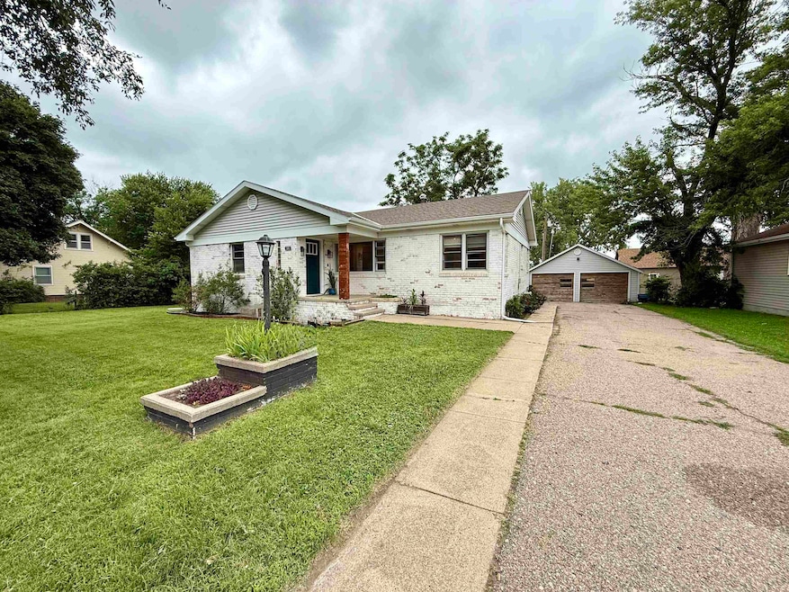
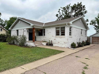
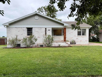


Small Town Living! Check out this 4 bedroom, 2 bathroom, open-concept, updated home which offers an updated kitchen, updated bathrooms, large bedrooms, large family room, mudroom, 4th bedroom downstairs with a walk-in closet, non-conforming bonus room, large laundry room, plenty of storage, plus so much more! The home is situated on a large, fenced-in lot and features a shed, a deck, and a 1276 sf. detached 4 car tandem garage with a workshop, and roll-top door with convenient alley access. Call for a showing today!
Last Agent to Sell the Property
Berkshire Hathaway HomeServices Da-Ly Realty License #20180038 Listed on: 07/18/2025

| Date | Type | Sale Price | Title Company |
|---|---|---|---|
| Warranty Deed | $220,000 | Charter Title | |
| Warranty Deed | $112,000 | Adams Land Title |
| Date | Status | Loan Amount | Loan Type |
|---|---|---|---|
| Open | $205,000 | New Conventional | |
| Previous Owner | $89,600 | New Conventional |
| Date | Event | Price | List to Sale | Price per Sq Ft |
|---|---|---|---|---|
| 08/22/2025 08/22/25 | Sold | $220,000 | +2.3% | $84 / Sq Ft |
| 08/04/2025 08/04/25 | Pending | -- | -- | -- |
| 07/18/2025 07/18/25 | For Sale | $215,000 | -- | $83 / Sq Ft |
| Year | Tax Paid | Tax Assessment Tax Assessment Total Assessment is a certain percentage of the fair market value that is determined by local assessors to be the total taxable value of land and additions on the property. | Land | Improvement |
|---|---|---|---|---|
| 2025 | $1,466 | $124,340 | $8,840 | $115,500 |
| 2024 | $1,466 | $124,340 | $8,840 | $115,500 |
| 2023 | $1,818 | $119,930 | $8,750 | $111,180 |
| 2022 | $1,556 | $93,725 | $3,500 | $90,225 |
| 2021 | $1,569 | $93,725 | $3,500 | $90,225 |
| 2020 | $1,380 | $80,615 | $3,500 | $77,115 |
| 2019 | $1,314 | $80,615 | $3,500 | $77,115 |
| 2018 | $1,180 | $80,615 | $3,500 | $77,115 |
| 2017 | $1,156 | $87,820 | $3,500 | $84,320 |
| 2016 | $1,104 | $87,820 | $3,500 | $84,320 |
| 2015 | $1,296 | $87,820 | $3,500 | $84,320 |
| 2014 | $1,566 | $87,820 | $3,500 | $84,320 |
| 2013 | $1,566 | $70,505 | $3,500 | $67,005 |
K
Seller's Agent in 2025
Kellie Abrams
Berkshire Hathaway HomeServices Da-Ly Realty
(402) 984-3558
98 Total Sales
Buyer's Agent in 2025
Brent Parker
Nebraska Realty Hastings
(402) 984-4092
65 Total Sales
Source: REALTORS® of Greater Mid-Nebraska
MLS Number: 20250908
APN: 586000
Ask me questions while you tour the home.