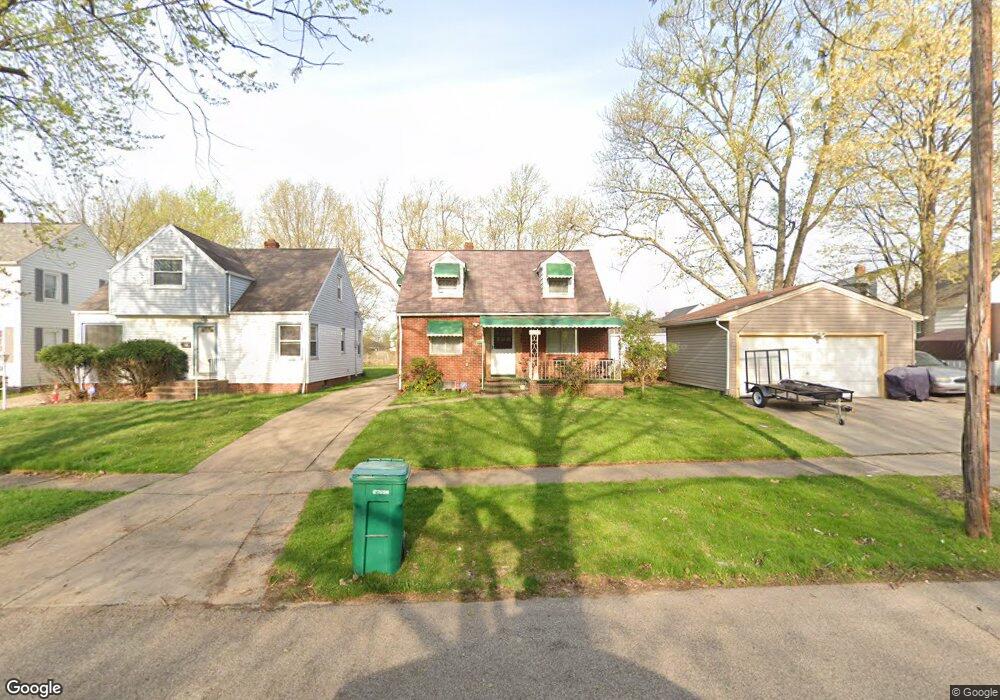
5034 Erwin St Maple Heights, OH 44137
Estimated Value: $123,237 - $158,000
3
Beds
2
Baths
1,218
Sq Ft
$110/Sq Ft
Est. Value
About This Home
This home is located at 5034 Erwin St, Maple Heights, OH 44137 and is currently estimated at $133,559, approximately $109 per square foot. 5034 Erwin St is a home located in Cuyahoga County with nearby schools including Abraham Lincoln Elementary School, Rockside/ J.F. Kennedy School, and Barack Obama School.
Ownership History
Date
Name
Owned For
Owner Type
Purchase Details
Closed on
Nov 2, 1999
Sold by
Ilenin Mary F
Bought by
Felleke Girma and Demissie Haregewoin
Current Estimated Value
Home Financials for this Owner
Home Financials are based on the most recent Mortgage that was taken out on this home.
Original Mortgage
$76,000
Outstanding Balance
$19,556
Interest Rate
6.99%
Estimated Equity
$114,003
Purchase Details
Closed on
Nov 23, 1977
Sold by
Linda Kathleen
Bought by
Ilenin Andrew
Purchase Details
Closed on
Jan 1, 1975
Bought by
Linda Kathleen
Create a Home Valuation Report for This Property
The Home Valuation Report is an in-depth analysis detailing your home's value as well as a comparison with similar homes in the area
Home Values in the Area
Average Home Value in this Area
Purchase History
| Date | Buyer | Sale Price | Title Company |
|---|---|---|---|
| Felleke Girma | $80,000 | American Title Trend Agency | |
| Ilenin Andrew | $40,000 | -- | |
| Linda Kathleen | -- | -- |
Source: Public Records
Mortgage History
| Date | Status | Borrower | Loan Amount |
|---|---|---|---|
| Open | Felleke Girma | $76,000 |
Source: Public Records
Tax History
| Year | Tax Paid | Tax Assessment Tax Assessment Total Assessment is a certain percentage of the fair market value that is determined by local assessors to be the total taxable value of land and additions on the property. | Land | Improvement |
|---|---|---|---|---|
| 2025 | $2,716 | $32,305 | $7,805 | $24,500 |
| 2024 | $3,015 | $32,305 | $7,805 | $24,500 |
| 2023 | $2,301 | $20,900 | $4,730 | $16,170 |
| 2022 | $2,293 | $20,900 | $4,730 | $16,170 |
| 2021 | $2,445 | $20,900 | $4,730 | $16,170 |
| 2020 | $2,089 | $15,820 | $3,570 | $12,250 |
| 2019 | $2,079 | $45,200 | $10,200 | $35,000 |
| 2018 | $2,068 | $15,820 | $3,570 | $12,250 |
| 2017 | $1,948 | $14,390 | $3,330 | $11,060 |
| 2016 | $1,884 | $14,390 | $3,330 | $11,060 |
| 2015 | $1,883 | $14,390 | $3,330 | $11,060 |
| 2014 | $1,883 | $15,820 | $3,640 | $12,180 |
Source: Public Records
Map
Nearby Homes
- 5100 Erwin St
- 5031 Cato St
- 5127 Erwin St
- 5150 Arch St
- 18851 Raymond St
- 18915 Longview Ave
- 18990 Raymond St
- 5177 Cato St
- 5219 Joseph St
- 5082 Philip Ave
- 5239 Arch St
- 17282 Mccracken Rd
- 5194 Homewood Ave
- 5231 Philip Ave
- 5165 Camden Rd
- 18715 Libby Rd
- 5246 Philip Ave
- 4744 E 176th St
- 19411 Marvin Rd
- 17806 Tarkington Ave
- 5038 Erwin St
- 5042 Erwin St
- 18340 Mccracken Rd
- 18360 Mccracken Rd
- 18320 Mccracken Rd
- 18380 Mccracken Rd
- 18300 Mccracken Rd
- 5050 Erwin St
- 18280 Mccracken Rd
- 5033 Joseph St
- 5037 Joseph St
- 5041 Joseph St
- 5054 Erwin St
- 5033 Erwin St
- 5051 Joseph St
- 18220 Mccracken Rd
- 5037 Erwin St
- 5041 Erwin St
- 18420 Mccracken Rd
- 5053 Joseph St
Your Personal Tour Guide
Ask me questions while you tour the home.