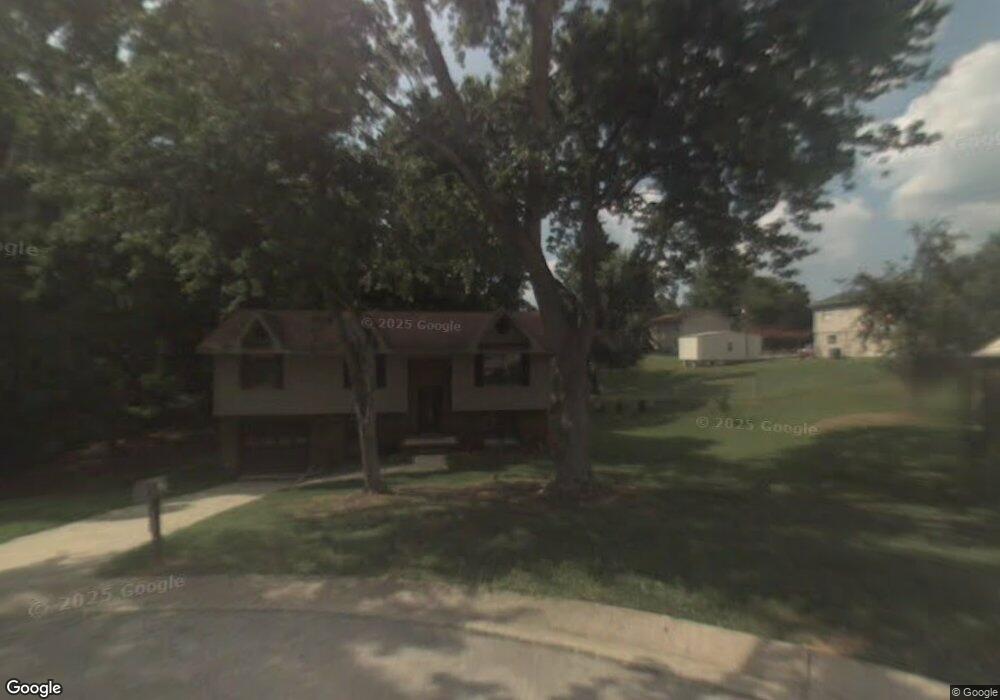
504 Cattail Cir Gardendale, AL 35071
Estimated Value: $204,000 - $235,000
3
Beds
2
Baths
1,132
Sq Ft
$192/Sq Ft
Est. Value
About This Home
This home is located at 504 Cattail Cir, Gardendale, AL 35071 and is currently estimated at $217,345, approximately $192 per square foot. 504 Cattail Cir is a home located in Jefferson County with nearby schools including Snow Rogers Elementary School, Bragg Middle School, and Gardendale High School.
Ownership History
Date
Name
Owned For
Owner Type
Purchase Details
Closed on
Apr 25, 2005
Sold by
Millican John Anthony and Millican Starla Poston
Bought by
Wm Specialty Mortgage Llc
Current Estimated Value
Purchase Details
Closed on
Jun 17, 1999
Sold by
Millican John Anthony S
Bought by
Millican John Anthony
Home Financials for this Owner
Home Financials are based on the most recent Mortgage that was taken out on this home.
Original Mortgage
$71,200
Interest Rate
10.25%
Create a Home Valuation Report for This Property
The Home Valuation Report is an in-depth analysis detailing your home's value as well as a comparison with similar homes in the area
Home Values in the Area
Average Home Value in this Area
Purchase History
| Date | Buyer | Sale Price | Title Company |
|---|---|---|---|
| Wm Specialty Mortgage Llc | $98,321 | -- | |
| Millican John Anthony | -- | -- |
Source: Public Records
Mortgage History
| Date | Status | Borrower | Loan Amount |
|---|---|---|---|
| Previous Owner | Millican John Anthony | $71,200 |
Source: Public Records
Tax History Compared to Growth
Tax History
| Year | Tax Paid | Tax Assessment Tax Assessment Total Assessment is a certain percentage of the fair market value that is determined by local assessors to be the total taxable value of land and additions on the property. | Land | Improvement |
|---|---|---|---|---|
| 2024 | $1,048 | $18,320 | -- | -- |
| 2022 | $931 | $16,370 | $5,200 | $11,170 |
| 2021 | $799 | $14,180 | $5,200 | $8,980 |
| 2020 | $730 | $13,010 | $5,200 | $7,810 |
| 2019 | $730 | $13,020 | $0 | $0 |
| 2018 | $698 | $12,500 | $0 | $0 |
| 2017 | $725 | $12,940 | $0 | $0 |
| 2016 | $683 | $12,240 | $0 | $0 |
| 2015 | $698 | $12,500 | $0 | $0 |
| 2014 | $554 | $12,020 | $0 | $0 |
| 2013 | $554 | $12,020 | $0 | $0 |
Source: Public Records
Map
Nearby Homes
- 504 Buckskin Ln
- 2751 Rhody Dr
- 145 Scenic Dr
- 172 Scenic Dr
- 125 Sylvia Dr
- 384 Hickory Rd
- 313 Belcher Hill Rd Unit 1
- 5813 William O Ln
- 7044 Turnberry Highlands Cove
- 5705 Garden Wood Dr
- 3625 Ash Place
- 362 Rock Dr
- 2263 Mount Olive Rd Unit 3-5
- 7135 Oak Crescent Ln
- 261 Rock Dr
- 7157 Pine Mountain Cir
- 7184 Pine Mountain Cir
- 2256 Pinehurst Dr
- 6344 Spring Hollow Rd
- 5634 Hunter Brook Ct
- 2812 North Rd
- 513 Cattail Cir
- 500 Cattail Cir
- 509 Cattail Cir
- 501 Buckskin Ln
- 505 Buckskin Ln
- 2820 North Rd
- 505 Cattail Cir
- 509 Buckskin Ln
- 501 Cattail Cir
- 512 Foxfire Dr
- 508 Foxfire Dr
- 2817 North Rd
- 2813 North Rd
- 500 Buckskin Ln
- 513 Buckskin Ln
- 516 Foxfire Dr
- 2821 North Rd
- 508 Buckskin Ln
- 504 Foxfire Dr