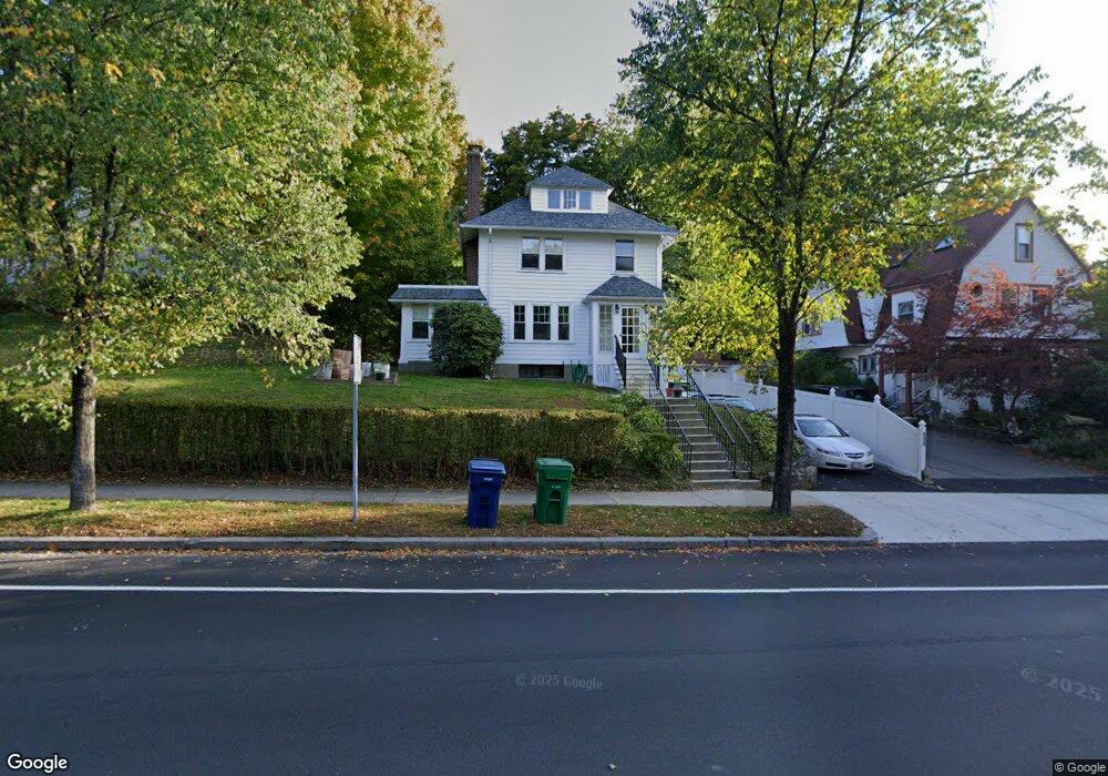
504 Commonwealth Ave Newton Center, MA 02459
Newton Centre NeighborhoodEstimated Value: $1,122,000 - $1,645,000
4
Beds
2
Baths
1,429
Sq Ft
$909/Sq Ft
Est. Value
About This Home
This home is located at 504 Commonwealth Ave, Newton Center, MA 02459 and is currently estimated at $1,299,555, approximately $909 per square foot. 504 Commonwealth Ave is a home located in Middlesex County with nearby schools including Ward Elementary School, Mason Rice Elementary School, and Charles E Brown Middle School.
Ownership History
Date
Name
Owned For
Owner Type
Purchase Details
Closed on
Jan 17, 2020
Sold by
Wing David A and Brophy Karen W
Bought by
Wing David A and Wing Jones P
Current Estimated Value
Purchase Details
Closed on
Jul 25, 2008
Sold by
Wing Elizabeth Jung and Wing Jones David
Bought by
Wing David Alexander and Wing Jones Philip
Create a Home Valuation Report for This Property
The Home Valuation Report is an in-depth analysis detailing your home's value as well as a comparison with similar homes in the area
Home Values in the Area
Average Home Value in this Area
Purchase History
| Date | Buyer | Sale Price | Title Company |
|---|---|---|---|
| Wing David A | -- | None Available | |
| Wing David Alexander | -- | -- |
Source: Public Records
Tax History Compared to Growth
Tax History
| Year | Tax Paid | Tax Assessment Tax Assessment Total Assessment is a certain percentage of the fair market value that is determined by local assessors to be the total taxable value of land and additions on the property. | Land | Improvement |
|---|---|---|---|---|
| 2025 | $8,552 | $872,700 | $0 | $0 |
| 2024 | $8,270 | $0 | $0 | $0 |
| 2023 | $7,748 | $761,100 | $721,400 | $39,700 |
| 2022 | $7,413 | $704,700 | $668,000 | $36,700 |
| 2021 | $7,153 | $664,800 | $630,200 | $34,600 |
| 2020 | $6,941 | $664,800 | $630,200 | $34,600 |
| 2019 | $6,744 | $645,400 | $611,800 | $33,600 |
| 2018 | $6,385 | $590,100 | $550,600 | $39,500 |
| 2017 | $6,191 | $556,700 | $519,400 | $37,300 |
| 2016 | $5,921 | $520,300 | $485,400 | $34,900 |
| 2015 | $5,646 | $486,300 | $453,600 | $32,700 |
Source: Public Records
Map
Nearby Homes
- 92 Grant Ave
- 44 Irving St
- 21 Francis St Unit 21A
- 23 Francis St Unit 23-1
- 9 The Ledges Rd
- 1004 Centre St
- 31 W Boulevard Rd
- 145 Warren St Unit 4
- 173-175 Warren St
- 5 Merrill Rd
- 5 Hammond St
- 154 Langley Rd Unit 1
- 73 Elmore St
- 9 Ripley St Unit 1
- 20 Bartlett Terrace
- 104 Woodchester Dr
- 209 Commonwealth Ave Unit 3E
- 0,351&335 Langley Rd
- Lot 3 Chapin Rd
- Lot 2 Chapin Rd
- 101 Grant Ave
- 516 Commonwealth Ave
- 105 Grant Ave
- 496 Commonwealth Ave
- 111 Grant Ave
- 518 Commonwealth Ave
- 10 Read Ct
- 117 Grant Ave
- 14 Read Ct
- 14 Read Ct Unit 1
- 491 Commonwealth Ave
- 489 Commonwealth Ave Unit 491
- 106 Grant Ave
- 98 Grant Ave
- 12 Read Ct Unit 2
- 12-14 Read Ct
- 12/14 Read
- 12 Read Ct Unit 3
- 12-14 Read Ct Unit 3
- 12-14 Read Ct Unit 2