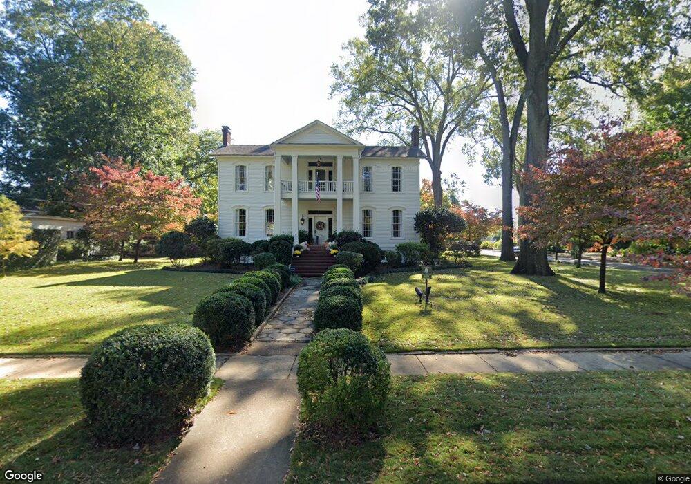
504 Line St NE Decatur, AL 35601
Old Decatur NeighborhoodEstimated Value: $576,000 - $856,811
--
Bed
1
Bath
4,194
Sq Ft
$169/Sq Ft
Est. Value
About This Home
This home is located at 504 Line St NE, Decatur, AL 35601 and is currently estimated at $709,270, approximately $169 per square foot. 504 Line St NE is a home located in Morgan County with nearby schools including Banks-Caddell Elementary School, Horizon High School, and Decatur Middle School.
Ownership History
Date
Name
Owned For
Owner Type
Purchase Details
Closed on
Dec 10, 2020
Sold by
Tubb J Glynn J and Tubb Catherine W
Bought by
Riehl John Randall and Riehl Lauren J
Current Estimated Value
Home Financials for this Owner
Home Financials are based on the most recent Mortgage that was taken out on this home.
Original Mortgage
$510,400
Outstanding Balance
$455,219
Interest Rate
2.8%
Mortgage Type
New Conventional
Estimated Equity
$254,051
Purchase Details
Closed on
Jun 10, 2005
Sold by
Lacy Edward H and Lacy Jane
Bought by
Tubb Glynn J and Tubb Catherine W
Create a Home Valuation Report for This Property
The Home Valuation Report is an in-depth analysis detailing your home's value as well as a comparison with similar homes in the area
Home Values in the Area
Average Home Value in this Area
Purchase History
| Date | Buyer | Sale Price | Title Company |
|---|---|---|---|
| Riehl John Randall | $660,000 | None Available | |
| Tubb Glynn J | -- | None Available |
Source: Public Records
Mortgage History
| Date | Status | Borrower | Loan Amount |
|---|---|---|---|
| Open | Riehl John Randall | $510,400 |
Source: Public Records
Tax History Compared to Growth
Tax History
| Year | Tax Paid | Tax Assessment Tax Assessment Total Assessment is a certain percentage of the fair market value that is determined by local assessors to be the total taxable value of land and additions on the property. | Land | Improvement |
|---|---|---|---|---|
| 2024 | $2,698 | $60,590 | $9,130 | $51,460 |
| 2023 | $2,698 | $60,490 | $9,130 | $51,360 |
| 2022 | $2,693 | $60,490 | $9,130 | $51,360 |
| 2021 | $1,580 | $41,260 | $9,130 | $32,130 |
| 2020 | $1,632 | $76,070 | $9,130 | $66,940 |
| 2019 | $0 | $42,620 | $9,130 | $33,470 |
| 2015 | $1,635 | $38,320 | $0 | $0 |
| 2014 | $1,635 | $37,140 | $0 | $0 |
| 2013 | -- | $37,760 | $0 | $0 |
Source: Public Records
Map
Nearby Homes
- 602 Line St NE
- 511 Line St NE
- 506 Ferry St NE
- 722 Ferry St NE
- 216 Cain St NE
- 216 Lafayette St NE
- 207 Cain St NE
- 504 Walnut St NE
- 622 Canal St NE
- 422 Lafayette St NE
- 406 Canal St NE
- 904 Line St NE
- 812 Well St NE
- 301 Oak St NE
- 118 Church St
- 111 Church St NW
- 626 Grant St SE
- Lot 13 4th Ave NW
- 615 Grant St SE
- 623 Grant St SE
- 514 Line St NE
- 520 Line St NE
- 311 Walnut St NE
- 503 Ferry St NE
- 511 Ferry St NE
- 517 Ferry St NE
- 501 Line St NE
- 417 Line St NE
- 519 Line St NE
- 310 Walnut St NE
- 409 Line St NE
- 213 Cherry St NE
- 601 Line St NE
- 601 Ferry St NE
- 604 Line St NE
- 2ND 2ND Line St NE Unit 2
- 403 Line St NE
- 403 Line St NE Unit 2
- 514 Ferry St NE
- 512 Ferry St NE