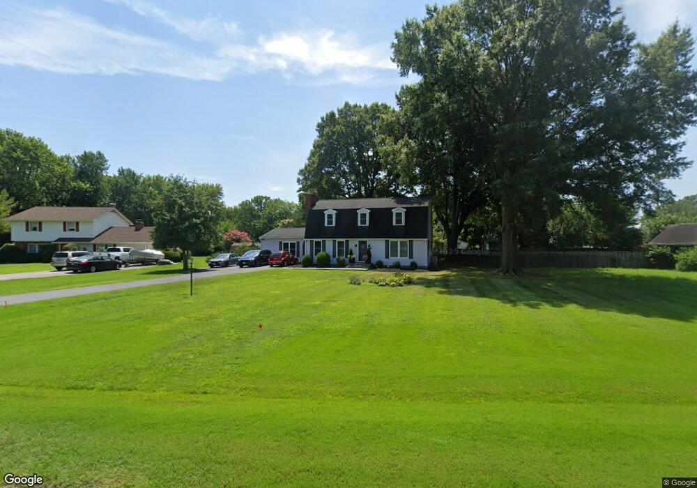
504 Skipper Ct Chester, MD 21619
Estimated Value: $507,000 - $558,000
Studio
3
Baths
2,856
Sq Ft
$186/Sq Ft
Est. Value
About This Home
This home is located at 504 Skipper Ct, Chester, MD 21619 and is currently estimated at $530,733, approximately $185 per square foot. 504 Skipper Ct is a home located in Queen Anne's County with nearby schools including Kent Island Elementary School, Bayside Elementary School, and Stevensville Middle School.
Ownership History
Date
Name
Owned For
Owner Type
Purchase Details
Closed on
Aug 14, 2001
Sold by
Bell Thomas J
Bought by
Snapp James H and Snapp Cynthia M
Current Estimated Value
Purchase Details
Closed on
Sep 30, 1996
Sold by
Bell Thomas J
Bought by
Bell Thomas J and Bell Carol B
Purchase Details
Closed on
Jun 17, 1988
Sold by
Dolbey Stephen
Bought by
Bell Thomas J
Home Financials for this Owner
Home Financials are based on the most recent Mortgage that was taken out on this home.
Original Mortgage
$96,000
Interest Rate
10.35%
Create a Home Valuation Report for This Property
The Home Valuation Report is an in-depth analysis detailing your home's value as well as a comparison with similar homes in the area
Home Values in the Area
Average Home Value in this Area
Purchase History
| Date | Buyer | Sale Price | Title Company |
|---|---|---|---|
| Snapp James H | $195,000 | -- | |
| Bell Thomas J | -- | -- | |
| Bell Thomas J | $120,000 | -- |
Source: Public Records
Mortgage History
| Date | Status | Borrower | Loan Amount |
|---|---|---|---|
| Previous Owner | Bell Thomas J | $96,000 | |
| Closed | Bell Thomas J | -- |
Source: Public Records
Tax History
| Year | Tax Paid | Tax Assessment Tax Assessment Total Assessment is a certain percentage of the fair market value that is determined by local assessors to be the total taxable value of land and additions on the property. | Land | Improvement |
|---|---|---|---|---|
| 2025 | $3,440 | $376,167 | $0 | $0 |
| 2024 | $3,270 | $353,033 | $0 | $0 |
| 2023 | $3,108 | $329,900 | $161,400 | $168,500 |
| 2022 | $3,070 | $325,867 | $0 | $0 |
| 2021 | $3,048 | $321,833 | $0 | $0 |
| 2020 | $3,048 | $317,800 | $161,400 | $156,400 |
| 2019 | $2,945 | $307,067 | $0 | $0 |
| 2018 | $2,842 | $296,333 | $0 | $0 |
| 2017 | $2,739 | $285,600 | $0 | $0 |
| 2016 | -- | $284,200 | $0 | $0 |
| 2015 | $1,344 | $282,800 | $0 | $0 |
| 2014 | $1,344 | $281,400 | $0 | $0 |
Source: Public Records
Map
Nearby Homes
- 205 Anchor Ln
- 3 D Queen Victoria Ct
- 135 Nauset Ln
- 27 Queen Mary Ct Unit F
- 6 G Queen Victoria Way
- 54H Queen Caroline Ct
- 4000 Herons Nest Way Unit 22
- 8 Queen Victoria Way
- 3000 Herons Nest Way Unit 11
- 54B Queen Caroline Ct
- 15 Queen Anne Way Unit E
- 204 Ringneck Ct
- 9B Queen Victoria Way
- 1000 Herons Nest Way Unit 32
- 1000 Herons Nest Way Unit 23
- 49 Queen Guinivere Way
- 306 Teal Ct
- 402 Blenny Ln
- 129 Sailcloth Way
- 106 Merganser Ct
Your Personal Tour Guide
Ask me questions while you tour the home.