Estimated Value: $570,452 - $741,000
5
Beds
3
Baths
3,430
Sq Ft
$184/Sq Ft
Est. Value
About This Home
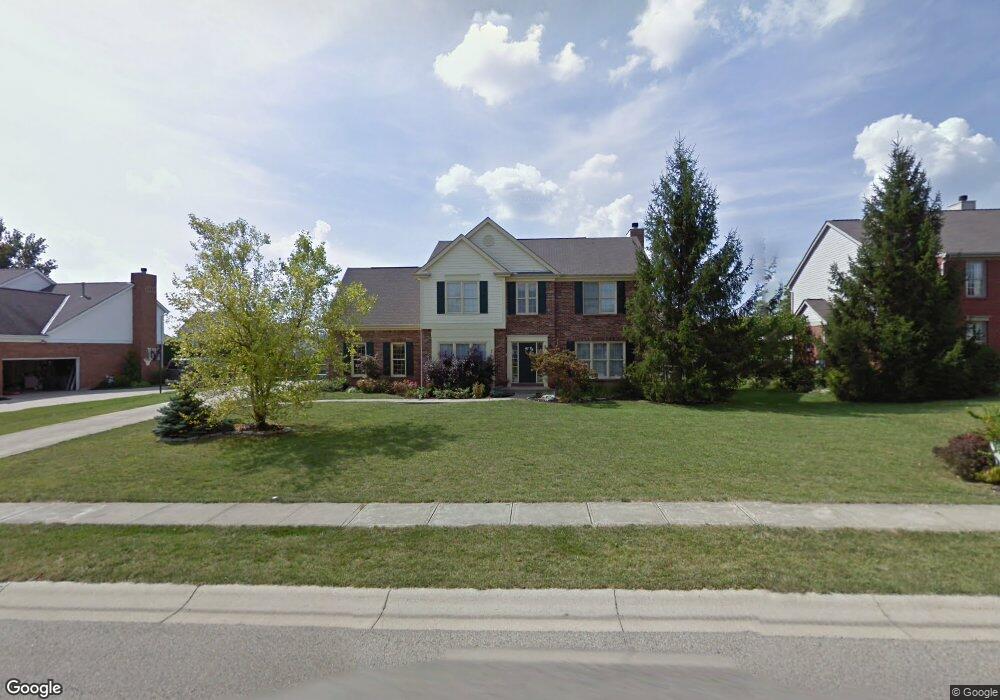
This home is located at 5045 Farmridge Way, Mason, OH 45040 and is currently estimated at $630,363, approximately $183 per square foot. 5045 Farmridge Way is a home located in Warren County with nearby schools including Mason Intermediate Elementary School, Mason Middle School, and William Mason High School.
Ownership History
Date
Name
Owned For
Owner Type
Purchase Details
Closed on
Apr 1, 2019
Sold by
Dynes Thomas B
Bought by
Dynes Family Revocable Living Trust
Current Estimated Value
Purchase Details
Closed on
Apr 1, 1994
Sold by
D R Horton & Inc
Bought by
Thomas Dynes and Thomas B.
Purchase Details
Closed on
Nov 13, 1992
Sold by
Campbell-Rhein Developmen
Bought by
D R Horton & Inc
Purchase Details
Closed on
Oct 7, 1992
Sold by
Campbell-Rhein Developmen
Bought by
Campbell-Rhein Developmen
Create a Home Valuation Report for This Property
The Home Valuation Report is an in-depth analysis detailing your home's value as well as a comparison with similar homes in the area
Home Values in the Area
Average Home Value in this Area
Purchase History
| Date | Buyer | Sale Price | Title Company |
|---|---|---|---|
| Dynes Family Revocable Living Trust | -- | None Available | |
| Thomas Dynes | $176,900 | -- | |
| D R Horton & Inc | $28,000 | -- | |
| Campbell-Rhein Developmen | -- | -- |
Source: Public Records
Tax History Compared to Growth
Tax History
| Year | Tax Paid | Tax Assessment Tax Assessment Total Assessment is a certain percentage of the fair market value that is determined by local assessors to be the total taxable value of land and additions on the property. | Land | Improvement |
|---|---|---|---|---|
| 2024 | $6,257 | $154,170 | $42,000 | $112,170 |
| 2023 | $5,673 | $118,100 | $24,360 | $93,740 |
| 2022 | $5,600 | $118,101 | $24,360 | $93,741 |
| 2021 | $5,305 | $118,101 | $24,360 | $93,741 |
| 2020 | $5,334 | $101,812 | $21,000 | $80,812 |
| 2019 | $4,904 | $101,812 | $21,000 | $80,812 |
| 2018 | $4,920 | $101,812 | $21,000 | $80,812 |
| 2017 | $4,398 | $84,949 | $17,371 | $67,578 |
| 2016 | $4,530 | $84,949 | $17,371 | $67,578 |
| 2015 | $4,539 | $84,949 | $17,371 | $67,578 |
| 2014 | $4,425 | $77,230 | $15,790 | $61,440 |
| 2013 | $4,435 | $85,580 | $17,500 | $68,080 |
Source: Public Records
Map
Nearby Homes
- 5088 Harvestdale Dr
- 5280 Sunset Ridge Dr
- 5864 Grazing Ct
- 6329 Caddies Way
- 5017 Ainsley Dr
- 4874 Shagbark Ct
- 5513 Harvestdale Dr
- 5662 Hawthorn Ct
- 5728 Running Fox Ln
- Vanderburgh Plan at Ivy Lane
- Belleville Plan at Ivy Lane
- Buchanan Plan at Ivy Lane
- Alden Plan at Ivy Lane
- Naples Plan at Ivy Lane
- Quentin Plan at Ivy Lane
- Hialeah Plan at Ivy Lane
- Ashton Plan at Ivy Lane
- Beachwood Plan at Ivy Lane
- Saxon Plan at Ivy Lane
- 5815 Running Fox Ln
- 5061 Farmridge Way
- 5025 Farmridge Way
- 5048 Harvestdale Dr
- 5042 Harvestdale Dr
- 5077 Farmridge Way
- 5042 Farmridge Way
- 5066 Harvestdale Dr
- 5056 Farmridge Way
- 5074 Farmridge Way
- 5020 Farmridge Way
- 5097 Farmridge Way
- 5033 Harvestdale Dr
- 5092 Farmridge Way
- 5061 Barnwood Ct
- 5071 Barnwood Ct
- 5106 Harvestdale Dr
- 5057 Harvestdale Dr
- 5037 Harvestdale Dr
- 4985 Colt Ln
- 5111 Farmridge Way