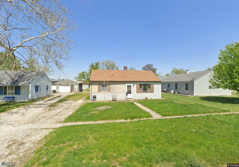
505 E Cedar Ln Mount Pleasant, IA 52641
Estimated Value: $94,000 - $108,000
3
Beds
1
Bath
816
Sq Ft
$125/Sq Ft
Est. Value
About This Home
This home is located at 505 E Cedar Ln, Mount Pleasant, IA 52641 and is currently estimated at $102,060, approximately $125 per square foot. 505 E Cedar Ln is a home located in Henry County with nearby schools including Mount Pleasant High School and Mount Pleasant Christian School.
Ownership History
Date
Name
Owned For
Owner Type
Purchase Details
Closed on
Sep 19, 2023
Sold by
English Linda Lou
Bought by
Lamm Brothers Investments Llc
Current Estimated Value
Home Financials for this Owner
Home Financials are based on the most recent Mortgage that was taken out on this home.
Original Mortgage
$42,750
Outstanding Balance
$41,843
Interest Rate
6.96%
Mortgage Type
Credit Line Revolving
Estimated Equity
$60,217
Purchase Details
Closed on
Jun 22, 2021
Sold by
English Lyle A
Bought by
English Linda L
Create a Home Valuation Report for This Property
The Home Valuation Report is an in-depth analysis detailing your home's value as well as a comparison with similar homes in the area
Home Values in the Area
Average Home Value in this Area
Purchase History
| Date | Buyer | Sale Price | Title Company |
|---|---|---|---|
| Lamm Brothers Investments Llc | $47,500 | None Listed On Document | |
| English Linda L | -- | None Available |
Source: Public Records
Mortgage History
| Date | Status | Borrower | Loan Amount |
|---|---|---|---|
| Open | Lamm Brothers Investments Llc | $42,750 |
Source: Public Records
Tax History
| Year | Tax Paid | Tax Assessment Tax Assessment Total Assessment is a certain percentage of the fair market value that is determined by local assessors to be the total taxable value of land and additions on the property. | Land | Improvement |
|---|---|---|---|---|
| 2025 | $1,150 | $67,340 | $9,240 | $58,100 |
| 2024 | $908 | $62,500 | $9,240 | $53,260 |
| 2023 | $990 | $62,500 | $9,240 | $53,260 |
| 2022 | $964 | $55,080 | $9,240 | $45,840 |
| 2021 | $964 | $55,080 | $9,240 | $45,840 |
| 2019 | $850 | $48,040 | $0 | $0 |
| 2018 | $812 | $48,040 | $0 | $0 |
| 2017 | $812 | $44,920 | $0 | $0 |
| 2016 | $734 | $44,920 | $0 | $0 |
| 2015 | $734 | $51,730 | $0 | $0 |
| 2014 | $860 | $51,730 | $0 | $0 |
Source: Public Records
Map
Nearby Homes
- 305 N Poplar St
- 703 N College Ave
- 414 N Main St
- 302 N Adams St
- 610 E Henry St
- 401 E Becky Ln
- 103 W Saunders St
- 412 N Broadway St
- 704 N Broadway St
- 805 E Madison St
- 301 N Jefferson St
- 3-71-6 N Grand Ave
- 407 E Mill St
- 302 W State St
- 511 E Washington St
- 204 W Henry St
- 909 E Madison St
- 408 N White St
- 301 W Henry St
- 600 E Washington St
- 503 E Cedar Ln
- 601 N Lombardy Rd
- 603 N Lombardy Rd
- 501 E Cedar Ln
- 602 N Carol Ave
- 605 N Lombardy Rd
- 604 N Carol Ave
- 601 E Cedar Ln
- 504 E Cedar Ln
- 601 N Carol Ave
- 502 E Cedar Ln
- 607 N Lombardy Rd
- 602 N Lombardy Rd
- 606 N Carol Ave
- 603 E Cedar Ln
- 604 N Lombardy Rd
- 603 N Carol Ave
- 609 N Lombardy Rd
- 608 N Carol Ave
- 405 E Cedar Ln
Your Personal Tour Guide
Ask me questions while you tour the home.