Estimated Value: $531,874 - $836,000
3
Beds
3
Baths
1,853
Sq Ft
$351/Sq Ft
Est. Value
About This Home
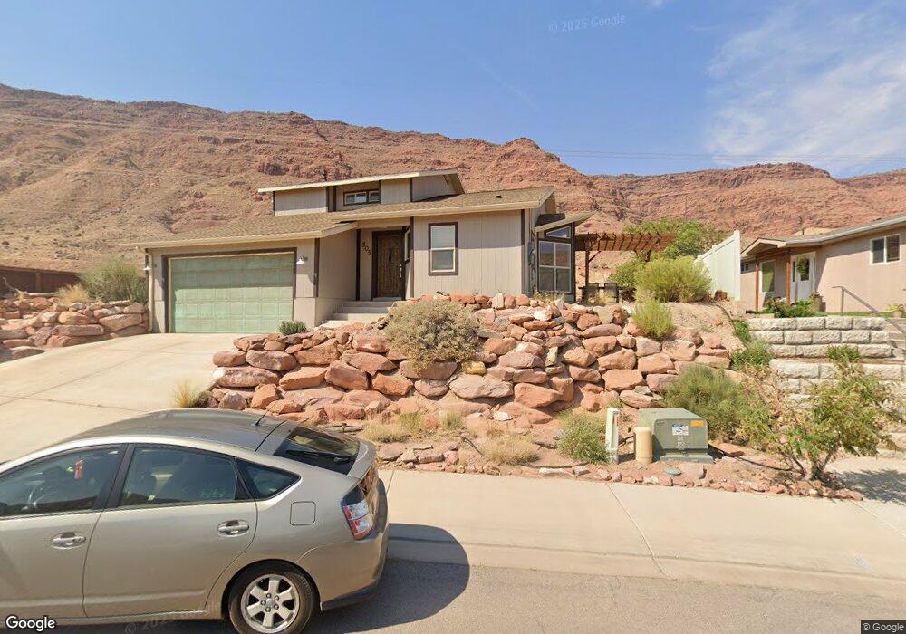
This home is located at 505 Huntridge Cir, Moab, UT 84532 and is currently estimated at $650,969, approximately $351 per square foot. 505 Huntridge Cir is a home with nearby schools including Helen M. Knight School, Grand County Middle School, and Grand County High School.
Ownership History
Date
Name
Owned For
Owner Type
Purchase Details
Closed on
Apr 22, 2009
Sold by
Vandecar Darin and Vandecar Michelle
Bought by
Olson Ross P and Olson Kelly L
Current Estimated Value
Home Financials for this Owner
Home Financials are based on the most recent Mortgage that was taken out on this home.
Original Mortgage
$234,500
Outstanding Balance
$147,358
Interest Rate
4.99%
Mortgage Type
New Conventional
Estimated Equity
$503,611
Create a Home Valuation Report for This Property
The Home Valuation Report is an in-depth analysis detailing your home's value as well as a comparison with similar homes in the area
Home Values in the Area
Average Home Value in this Area
Purchase History
| Date | Buyer | Sale Price | Title Company |
|---|---|---|---|
| Olson Ross P | -- | -- |
Source: Public Records
Mortgage History
| Date | Status | Borrower | Loan Amount |
|---|---|---|---|
| Open | Olson Ross P | $234,500 |
Source: Public Records
Tax History Compared to Growth
Tax History
| Year | Tax Paid | Tax Assessment Tax Assessment Total Assessment is a certain percentage of the fair market value that is determined by local assessors to be the total taxable value of land and additions on the property. | Land | Improvement |
|---|---|---|---|---|
| 2025 | $2,984 | $514,664 | $75,000 | $439,664 |
| 2024 | $2,984 | $514,664 | $75,000 | $439,664 |
| 2023 | $3,079 | $514,664 | $75,000 | $439,664 |
| 2022 | $2,591 | $501,858 | $75,000 | $426,858 |
| 2021 | $1,756 | $294,201 | $85,000 | $209,201 |
| 2020 | $1,822 | $294,201 | $85,000 | $209,201 |
| 2019 | $1,720 | $294,201 | $85,000 | $209,201 |
| 2018 | $1,530 | $264,201 | $55,000 | $209,201 |
| 2017 | $1,585 | $0 | $0 | $0 |
| 2016 | $1,569 | $0 | $0 | $0 |
| 2015 | $1,516 | $0 | $0 | $0 |
| 2014 | $1,460 | $0 | $0 | $0 |
| 2013 | $1,461 | $141,234 | $0 | $0 |
Source: Public Records
Map
Nearby Homes
- 475 Kane Creek Blvd Unit 2
- 443 Kane Creek Blvd Unit 211
- 443 Kane Creek Blvd Unit 111
- 443 Kane Creek Blvd Unit A104
- 443 Kane Creek Blvd Unit B214
- 491 S Mountain View Dr
- 127 Birch Ave
- 766 Huntridge Dr
- 545 Kane Creek Blvd
- 396 W 200 S
- 168 S 100 W
- 855 David Ct Unit 34
- 67 S 100 W
- 275 Williams Way Unit 1-5
- 836 S Main St
- 214 S 200 E Unit 6
- 214 S 200 E Unit 7
- 214 S 200 E Unit 9
- 214 S 200 E Unit 4
- 214 S 200 E Unit 5
- 505 Huntridge Cir
- 389 S Huntridge Cir
- 515 Huntridge Cir
- 515 Huntridge Cir Unit 22
- 485 Huntridge Cir
- 475 Mckay Place
- 555 Huntridge Cir
- 389 Huntridge Dr
- 525 Huntridge Cir
- 545 Huntridge Cir
- 465 Mckay Place
- 465 Mckay Place Unit 26
- 473 Doc Allen Dr
- 535 Huntridge Cir
- 476 Huntridge Dr Unit 3
- 455 Mckay Place
- 495 Doc Allen Dr
- 466 Mckay Place Unit 2
- 507 Doc Allen Dr
- 445 Mckay Place