
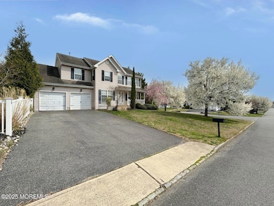
505 Mermaid Dr Manahawkin, NJ 08050
Stafford NeighborhoodEstimated payment $3,804/month
Highlights
- In Ground Pool
- Fireplace
- 2 Car Attached Garage
- No HOA
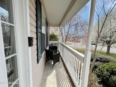
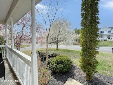
- Porch
- Forced Air Heating and Cooling System
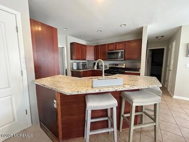
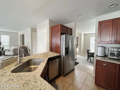
About This Home
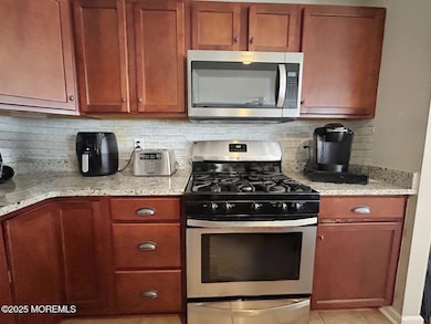
This charming two-story home offers the perfect blend of comfort, space, and functionality. Featuring four spacious bedrooms, two full bathrooms, and a convenient half bath, it is well-suited for families or those who love to entertain. Enter to find a warm and inviting interior with central air conditioning and forced-air heating, ensuring year-round comfort. The main floor includes a bright and open living area, a well-appointed kitchen, and a dining space that flows seamlessly for entertaining. The bedrooms offer generous space and ample closet storage, with the primary suite boasting a private en-suite full bathroom. Outside, enjoy your own private retreat with a fenced-in backyard that includes a beautifully maintained in-ground pool. Tenant-occupied
Home Details
Home Type
- Single Family
Est. Annual Taxes
- $7,893
Year Built
- Built in 2002
Lot Details
- 0.27 Acre Lot
- Fenced
Parking
- 2 Car Attached Garage
- Driveway
Home Design
- Shingle Roof
Interior Spaces
- 2,242 Sq Ft Home
- 2-Story Property
- Fireplace
- Partially Finished Basement
Bedrooms and Bathrooms
- 4 Bedrooms
Outdoor Features
- In Ground Pool
- Porch
Schools
- Ocean Acres Elementary School
- Southern Reg Middle School
- Southern Reg High School
Utilities
- Forced Air Heating and Cooling System
- Natural Gas Water Heater
Community Details
- No Home Owners Association
- Ocean Acres Subdivision
Listing and Financial Details
- Assessor Parcel Number 31-00044-184-00001
Map
Home Values in the Area
Average Home Value in this Area
Tax History
| Year | Tax Paid | Tax Assessment Tax Assessment Total Assessment is a certain percentage of the fair market value that is determined by local assessors to be the total taxable value of land and additions on the property. | Land | Improvement |
|---|---|---|---|---|
| 2025 | $7,893 | $317,900 | $67,700 | $250,200 |
| 2024 | $7,817 | $317,900 | $67,700 | $250,200 |
| 2023 | $7,483 | $317,900 | $67,700 | $250,200 |
| 2022 | $7,483 | $317,900 | $67,700 | $250,200 |
| 2021 | $7,382 | $317,900 | $67,700 | $250,200 |
| 2020 | $7,391 | $317,900 | $67,700 | $250,200 |
| 2019 | $7,286 | $317,900 | $67,700 | $250,200 |
| 2018 | $7,242 | $317,900 | $67,700 | $250,200 |
| 2017 | $7,290 | $309,800 | $67,700 | $242,100 |
| 2016 | $7,215 | $309,800 | $67,700 | $242,100 |
| 2015 | $6,961 | $309,800 | $67,700 | $242,100 |
| 2014 | $6,839 | $300,600 | $67,700 | $232,900 |
Property History
| Date | Event | Price | List to Sale | Price per Sq Ft |
|---|---|---|---|---|
| 11/04/2025 11/04/25 | Price Changed | $599,900 | -1.6% | $268 / Sq Ft |
| 10/10/2025 10/10/25 | Price Changed | $609,900 | -3.2% | $272 / Sq Ft |
| 09/05/2025 09/05/25 | Price Changed | $629,900 | 0.0% | $281 / Sq Ft |
| 09/05/2025 09/05/25 | For Sale | $629,900 | -4.5% | $281 / Sq Ft |
| 08/03/2025 08/03/25 | Off Market | $659,900 | -- | -- |
| 06/25/2025 06/25/25 | For Sale | $659,900 | -- | $294 / Sq Ft |
Purchase History
| Date | Type | Sale Price | Title Company |
|---|---|---|---|
| Sheriffs Deed | $151,000 | -- | |
| Deed | $232,630 | -- |
Mortgage History
| Date | Status | Loan Amount | Loan Type |
|---|---|---|---|
| Previous Owner | $215,000 | No Value Available |
Source: MOREMLS (Monmouth Ocean Regional REALTORS®)
MLS Number: 22518831
APN: 31-00044-184-00001
Disclaimer: Certain information contained herein is derived from information provided by parties other than Homes.com. All information provided is deemed reliable, but is not guaranteed to be accurate and should be independently verified.
![]() IDX information is provided exclusively for personal, non-commercial use, and may not be used for any purpose other than to identify prospective properties consumers may be interested in purchasing.
IDX information is provided exclusively for personal, non-commercial use, and may not be used for any purpose other than to identify prospective properties consumers may be interested in purchasing.
Information is deemed reliable but not guaranteed.
- 100 Fawcett Blvd
- 175 Barracuda Rd
- 53 Lookout Dr
- 63 Lookout Dr
- 61 Milky Way Dr
- 2010 Breakers Dr
- 2018 Breakers Dr
- 2012 Breakers Dr
- 2014 Breakers Dr
- 2008 Breakers Dr
- 2016 Breakers Dr
- 10 Hampton Rd
- 1966 Breakers Dr
- 16 Newport Rd
- 96 Deerfield Dr
- 100 Deerfield Dr
- 107 Deerfield Dr
- 6 Jolly Roger Rd
- 4 Jolly Roger Rd
- 8 Jolly Roger Rd
- 13 Outsail Ave
- 79 Ash Rd
- 90 Atlantis Ave
- 148 Mizzen Ave
- 41 Atlantis Ave Unit B
- 1217 Galley Ave
- 1049 Mariner Ave
- 123 Spinnaker Ave
- 225 Mirage Blvd
- 64 1st St
- 64 Georgetown Blvd
- 101 Campbell Blvd
- 254 Hawthorne Ln
- 10 Mantoloking Dr
- 900 Barnegat Blvd N
- 218 Holly Ave
- 400 S Main St Unit 2
- 6 Reno Ct
- 290 N Main St Unit b9
- 28 Baybreeze Dr
