Estimated Value: $70,000 - $146,000
4
Beds
2
Baths
1,984
Sq Ft
$60/Sq Ft
Est. Value
About This Home
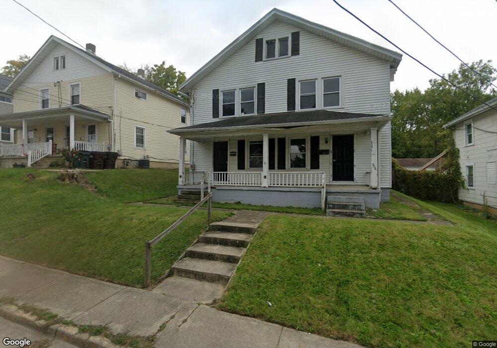
This home is located at 505 Stelton Rd, Xenia, OH 45385 and is currently estimated at $119,509, approximately $60 per square foot. 505 Stelton Rd is a home located in Greene County with nearby schools including Xenia High School, Summit Academy Community School for Alternative Learners - Xenia, and Legacy Christian Academy.
Ownership History
Date
Name
Owned For
Owner Type
Purchase Details
Closed on
Jan 18, 2023
Sold by
Krb Holdings Llc
Bought by
Knight Brother Property Llc
Current Estimated Value
Purchase Details
Closed on
Dec 3, 2014
Sold by
Kaws Holdings Llc
Bought by
Krb Holdings Llc
Purchase Details
Closed on
Aug 28, 2013
Sold by
Grieshop Nancy A
Bought by
Kaws Holdings Llc
Purchase Details
Closed on
Jul 30, 2004
Sold by
Kelble Shawn T and Kelble Lori M
Bought by
Grieshop Nancy A
Home Financials for this Owner
Home Financials are based on the most recent Mortgage that was taken out on this home.
Original Mortgage
$55,080
Interest Rate
6.35%
Mortgage Type
Commercial
Create a Home Valuation Report for This Property
The Home Valuation Report is an in-depth analysis detailing your home's value as well as a comparison with similar homes in the area
Home Values in the Area
Average Home Value in this Area
Purchase History
| Date | Buyer | Sale Price | Title Company |
|---|---|---|---|
| Knight Brother Property Llc | -- | -- | |
| Krb Holdings Llc | -- | None Available | |
| Kaws Holdings Llc | $99,500 | None Available | |
| Grieshop Nancy A | $61,200 | -- |
Source: Public Records
Mortgage History
| Date | Status | Borrower | Loan Amount |
|---|---|---|---|
| Previous Owner | Grieshop Nancy A | $55,080 |
Source: Public Records
Tax History Compared to Growth
Tax History
| Year | Tax Paid | Tax Assessment Tax Assessment Total Assessment is a certain percentage of the fair market value that is determined by local assessors to be the total taxable value of land and additions on the property. | Land | Improvement |
|---|---|---|---|---|
| 2024 | $1,229 | $19,030 | $4,640 | $14,390 |
| 2023 | $1,170 | $19,030 | $4,640 | $14,390 |
| 2022 | $1,988 | $25,300 | $3,710 | $21,590 |
| 2021 | $3,198 | $25,300 | $3,710 | $21,590 |
| 2020 | $4,862 | $25,300 | $3,710 | $21,590 |
| 2019 | $1,261 | $24,360 | $4,020 | $20,340 |
| 2018 | $1,423 | $24,360 | $4,020 | $20,340 |
| 2017 | $1,269 | $24,360 | $4,020 | $20,340 |
| 2016 | $1,209 | $22,830 | $4,020 | $18,810 |
| 2015 | $3,283 | $22,830 | $4,020 | $18,810 |
| 2014 | $3,383 | $22,830 | $4,020 | $18,810 |
Source: Public Records
Map
Nearby Homes
- 530 Cincinnati Ave
- 453 Walnut St
- 523 Newport Rd
- 633 Xenia Ave
- 305-325 Bellbrook Ave
- 293 S Miami Ave
- 100 Prugh Ave
- 46 Lake St
- 55 Lake St
- 400 S Detroit St
- 148 Home Ave
- 1208 Bellbrook Ave
- 260 Pocahontas St
- 1272 Bellbrook Ave
- 75 W 2nd St
- 36 Leaman St
- 222 Washington St
- 0 W Church St
- 1342 Kylemore Dr
- 1144 Rockwell Dr
- 505 Stelton Rd Unit 509
- 495 Stelton Rd
- 515 Stelton Rd
- 485 Stelton Rd
- 525 Stelton Rd
- 479 Stelton Rd
- 475 Stelton Rd
- 475 Stelton Rd Unit 475
- 475 Stelton Rd Unit 479
- 475-479 Stelton Rd
- 541 Stelton Rd
- 819 Cincinnati Ave
- 506 Stelton Rd
- 500 Stelton Rd
- 518 Stelton Rd
- 492 Stelton Rd
- 465 Stelton Rd
- 526 Stelton Rd
- 789 Cincinnati Ave
- 484 Stelton Rd