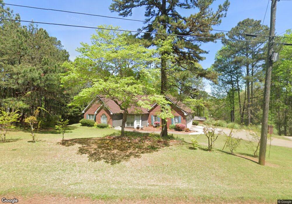
5053 Blackberry Ln Buford, GA 30518
Estimated Value: $527,035 - $779,000
3
Beds
2
Baths
2,052
Sq Ft
$317/Sq Ft
Est. Value
About This Home
This home is located at 5053 Blackberry Ln, Buford, GA 30518 and is currently estimated at $650,009, approximately $316 per square foot. 5053 Blackberry Ln is a home located in Hall County with nearby schools including Flowery Branch Elementary School, West Hall Middle School, and West Hall High School.
Ownership History
Date
Name
Owned For
Owner Type
Purchase Details
Closed on
Dec 20, 2002
Sold by
Mastrogiovanni Mary
Bought by
Ramirez Manuel
Current Estimated Value
Home Financials for this Owner
Home Financials are based on the most recent Mortgage that was taken out on this home.
Original Mortgage
$176,000
Outstanding Balance
$78,992
Interest Rate
5.92%
Mortgage Type
New Conventional
Estimated Equity
$571,017
Purchase Details
Closed on
Jan 1, 2000
Sold by
Tucker Virginia P
Bought by
Duhaime Virginia P
Purchase Details
Closed on
Jan 12, 1998
Sold by
Tucker James A
Bought by
Tucker Virginia P
Create a Home Valuation Report for This Property
The Home Valuation Report is an in-depth analysis detailing your home's value as well as a comparison with similar homes in the area
Home Values in the Area
Average Home Value in this Area
Purchase History
| Date | Buyer | Sale Price | Title Company |
|---|---|---|---|
| Ramirez Manuel | $220,000 | -- | |
| Duhaime Virginia P | -- | -- | |
| Tucker Virginia P | -- | -- |
Source: Public Records
Mortgage History
| Date | Status | Borrower | Loan Amount |
|---|---|---|---|
| Open | Ramirez Manuel | $176,000 |
Source: Public Records
Tax History Compared to Growth
Tax History
| Year | Tax Paid | Tax Assessment Tax Assessment Total Assessment is a certain percentage of the fair market value that is determined by local assessors to be the total taxable value of land and additions on the property. | Land | Improvement |
|---|---|---|---|---|
| 2025 | $5,257 | $217,640 | $37,840 | $179,800 |
| 2024 | $5,268 | $210,480 | $37,840 | $172,640 |
| 2023 | $5,399 | $215,800 | $56,480 | $159,320 |
| 2022 | $3,666 | $139,600 | $20,800 | $118,800 |
| 2021 | $3,466 | $129,360 | $19,280 | $110,080 |
| 2020 | $3,413 | $123,680 | $19,280 | $104,400 |
| 2019 | $3,238 | $116,120 | $19,280 | $96,840 |
| 2018 | $3,013 | $104,357 | $19,280 | $85,077 |
| 2017 | $2,981 | $104,357 | $19,280 | $85,077 |
| 2016 | $2,910 | $104,357 | $19,280 | $85,077 |
| 2015 | $2,933 | $104,357 | $19,280 | $85,077 |
| 2014 | $2,933 | $104,357 | $19,280 | $85,077 |
Source: Public Records
Map
Nearby Homes
- 6095 Blackberry Ln
- 6111 Blackberry Ln
- 3394 Lee Dr
- 6313 Shoreland Cir
- 3374 Lee Dr
- 6398 Snelling Mill Rd
- 6604 Windbrook Way
- 6181 Shoreland Cir
- 6397 Snelling Mill Rd
- 6708 Thornwood Ct
- 6732 Willowbrook Trail
- 6120 Hutchins Dr
- 6132 Hutchins Dr
- 6465 Yacht Club Rd
- 6446 Winter Harbor Dr
- 3907 Rustic Pine Ln
- 6509 Snug Harbor Ct
- 5051 Blackberry Ln
- 5039 Blackberry Ln
- 5939 Blackberry Ln
- 5939 Blackberry Ln Unit 1
- 5953 Blackberry Ln
- 5963 Blackberry Ln
- 5959 Blackberry Ln
- 5060 Blackberry Ln
- 5050 Blackberry Ln
- 5071 Blackberry Ln
- 5947 Blackberry Ln Unit 16181618
- 0 Blackberry Ln Unit 7257726
- 0 Blackberry Ln Unit 7534407
- 0 Blackberry Ln Unit 8418502
- 0 Blackberry Ln Unit 8093922
- 0 Blackberry Ln Unit 8765488
- 0 Blackberry Ln Unit 8777474
- 0 Blackberry Ln Unit 8852254
- 0 Blackberry Ln Unit 7081424
- 0 Blackberry Ln Unit 7254544