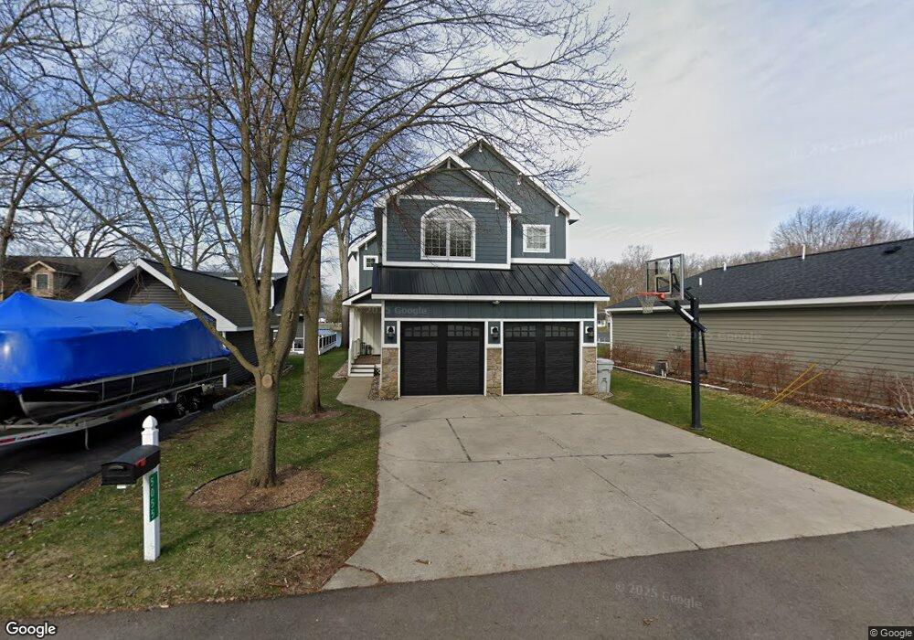
5055 Burton Dr Pinckney, MI 48169
Estimated Value: $973,000 - $1,072,000
3
Beds
3
Baths
3,044
Sq Ft
$333/Sq Ft
Est. Value
About This Home
This home is located at 5055 Burton Dr, Pinckney, MI 48169 and is currently estimated at $1,014,314, approximately $333 per square foot. 5055 Burton Dr is a home located in Livingston County with nearby schools including Country Elementary School, Navigator School, and Pathfinder School.
Ownership History
Date
Name
Owned For
Owner Type
Purchase Details
Closed on
Jun 4, 2024
Sold by
Morton Neal P and Morton Jennifer L
Bought by
Morton Neal P and Morton Jennifer L
Current Estimated Value
Purchase Details
Closed on
Mar 1, 2004
Sold by
Morton Neal and Morton Neal P
Bought by
Morton Neal P and Morton Jennifer L
Home Financials for this Owner
Home Financials are based on the most recent Mortgage that was taken out on this home.
Original Mortgage
$333,700
Interest Rate
4.87%
Mortgage Type
New Conventional
Create a Home Valuation Report for This Property
The Home Valuation Report is an in-depth analysis detailing your home's value as well as a comparison with similar homes in the area
Home Values in the Area
Average Home Value in this Area
Purchase History
| Date | Buyer | Sale Price | Title Company |
|---|---|---|---|
| Morton Neal P | -- | None Listed On Document | |
| Morton Neal P | -- | -- |
Source: Public Records
Mortgage History
| Date | Status | Borrower | Loan Amount |
|---|---|---|---|
| Previous Owner | Morton Neal P | $333,700 |
Source: Public Records
Tax History Compared to Growth
Tax History
| Year | Tax Paid | Tax Assessment Tax Assessment Total Assessment is a certain percentage of the fair market value that is determined by local assessors to be the total taxable value of land and additions on the property. | Land | Improvement |
|---|---|---|---|---|
| 2025 | $9,150 | $482,120 | $0 | $0 |
| 2024 | $2,962 | $453,660 | $0 | $0 |
| 2023 | $2,825 | $417,330 | $0 | $0 |
| 2022 | $6,014 | $373,400 | $0 | $0 |
| 2021 | $8,279 | $373,400 | $0 | $0 |
| 2020 | $8,158 | $365,450 | $0 | $0 |
| 2019 | $7,770 | $340,400 | $0 | $0 |
| 2018 | $7,655 | $308,620 | $0 | $0 |
| 2017 | $7,150 | $308,620 | $0 | $0 |
| 2016 | $7,390 | $299,070 | $0 | $0 |
| 2014 | $6,171 | $259,740 | $0 | $0 |
| 2012 | $6,171 | $249,670 | $0 | $0 |
Source: Public Records
Map
Nearby Homes
- 9929 Curie Ln
- 4825 Downing Dr
- 4790 Downing Dr
- 10250 Buhl Dr
- 10087 Margaret Dr
- 9862 Zukey Dr
- 5370 Edgelake Dr
- 00 Lori Ln
- 9550 Bluewater Dr
- 10868 Bob White Beach Blvd
- 4405 Shoreview Ln
- 5050 Island Shore Dr
- 0 Western Ln
- 3590 Habitat Trail Unit 25
- 4106 Shoreview Ln
- 11565 Locust Ln
- VL Michigan 36
- 5548 Seney Cir N
- 3450 Hooker Rd
- 6545 Hiller Ave