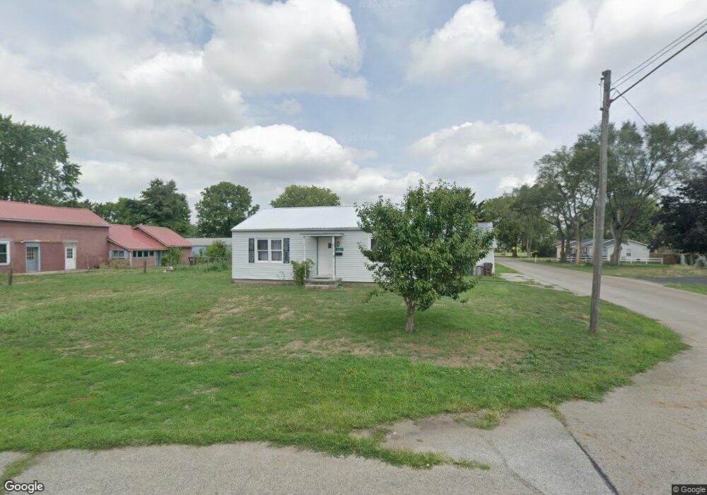
5056 E Main St South Bloomfield, OH 43103
Estimated Value: $183,672 - $269,000
2
Beds
1
Bath
864
Sq Ft
$252/Sq Ft
Est. Value
About This Home
This home is located at 5056 E Main St, South Bloomfield, OH 43103 and is currently estimated at $217,668, approximately $251 per square foot. 5056 E Main St is a home located in Pickaway County.
Ownership History
Date
Name
Owned For
Owner Type
Purchase Details
Closed on
Apr 24, 2025
Sold by
Winters Charles
Bought by
Winters Charles and Binkley Amber M
Current Estimated Value
Purchase Details
Closed on
Jan 22, 2020
Sold by
Carl Andrew Brannon and Carl Caitlin Marie
Bought by
Winters Charles
Home Financials for this Owner
Home Financials are based on the most recent Mortgage that was taken out on this home.
Original Mortgage
$29,456
Interest Rate
3.87%
Mortgage Type
FHA
Purchase Details
Closed on
Sep 12, 2013
Sold by
Carl William S
Bought by
Carl Andrew Brannon and Carl Caitlin Marie
Purchase Details
Closed on
Oct 4, 1991
Sold by
Brannon Jeanne
Bought by
Carl William S
Create a Home Valuation Report for This Property
The Home Valuation Report is an in-depth analysis detailing your home's value as well as a comparison with similar homes in the area
Home Values in the Area
Average Home Value in this Area
Purchase History
| Date | Buyer | Sale Price | Title Company |
|---|---|---|---|
| Winters Charles | -- | None Listed On Document | |
| Winters Charles | -- | None Listed On Document | |
| Winters Charles | $30,000 | Transcounty Title Agency Box | |
| Carl Andrew Brannon | -- | Attorney | |
| Carl William S | -- | -- |
Source: Public Records
Mortgage History
| Date | Status | Borrower | Loan Amount |
|---|---|---|---|
| Previous Owner | Winters Charles | $29,456 |
Source: Public Records
Tax History Compared to Growth
Tax History
| Year | Tax Paid | Tax Assessment Tax Assessment Total Assessment is a certain percentage of the fair market value that is determined by local assessors to be the total taxable value of land and additions on the property. | Land | Improvement |
|---|---|---|---|---|
| 2024 | -- | $45,210 | $9,540 | $35,670 |
| 2023 | $1,734 | $45,210 | $9,540 | $35,670 |
| 2022 | $1,410 | $33,870 | $7,950 | $25,920 |
| 2021 | $1,335 | $33,870 | $7,950 | $25,920 |
| 2020 | $1,338 | $33,870 | $7,950 | $25,920 |
| 2019 | $1,131 | $28,400 | $7,950 | $20,450 |
| 2018 | $1,171 | $28,400 | $7,950 | $20,450 |
| 2017 | $1,541 | $28,400 | $7,950 | $20,450 |
| 2016 | $1,110 | $26,140 | $7,850 | $18,290 |
| 2015 | $1,111 | $26,140 | $7,850 | $18,290 |
| 2014 | $1,762 | $26,140 | $7,850 | $18,290 |
| 2013 | $1,182 | $26,140 | $7,850 | $18,290 |
Source: Public Records
Map
Nearby Homes
- 0 U S 23
- 5050 S Walnut St
- 5049 Lee Rd
- 5069 Ashville Rd
- 14337 Us Highway 23
- 14337 Us Highway 23
- The Daffodil Plan at Riverbend at Scioto Landing
- The Daisy Plan at Riverbend at Scioto Landing
- The Avalon Plan at Riverbend at Scioto Landing
- The Aster Plan at Riverbend at Scioto Landing
- 51 Henderson Ln
- 127 Boutot St
- Longwood Plan at Walker Pointe
- Birmingham Plan at Walker Pointe
- Sanibel Plan at Walker Pointe
- Carlisle Plan at Walker Pointe
- Somerset Plan at Walker Pointe
- Chattanooga Plan at Walker Pointe
- Rockford Plan at Walker Pointe
- Hoover Plan at Walker Pointe