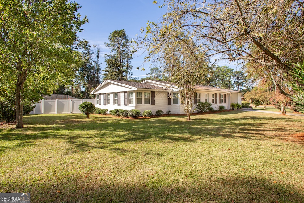

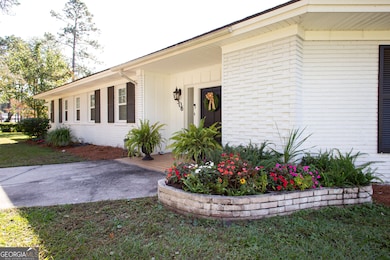
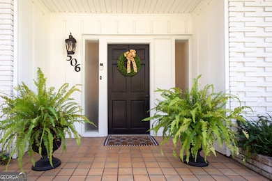
506 Magnolia Dr Waycross, GA 31501
Estimated payment $2,022/month
Highlights
- 1 Fireplace
- Corner Lot
- No HOA
- Sun or Florida Room
- High Ceiling
- Tennis Courts
About This Home
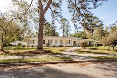
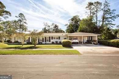
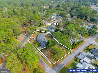
Welcome to 506 Magnolia Drive - a beautiful brick home nestled in the heart of the highly sought-after Cherokee Heights neighborhood sitting on a corner lot of 0.58 acres. This spacious residence offers four bedrooms, three full bathrooms, and one half-bathroom, blending timeless design with thoughtful modern updates. Step inside to find a welcoming foyer, large dining room, and living space accented by clean lines, generous windows, a cozy fireplace, and a view of your backyard oasis - complete with a vinyl privacy fence. The living room highlights rich wood-paneled walls, exposed ceiling beams, and gleaming terrazzo flooring that reflects an abundance of natural light streaming through the expansive wall of sliding glass doors. Natural light pours in from every angle, including through the inviting sunroom - perfect for morning coffee or quiet evenings at home. The home showcases stunning built-in cabinetry, plantation shutters, and a seamless flow between rooms, giving it both character and sophistication. The remodeled kitchen features updated finishes, opening into a super-sized dining area ideal for entertaining. The spacious laundry room provides added convenience, while every bedroom has direct access to a full bathroom for exceptional comfort. One bedroom is thoughtfully partitioned, offering flexible space for guests, a home office, or a playroom. The roof, main hot water heater, and windows have all been replaced within the last two years. With timeless brick construction of 3,000 square feet of interior living space and being within close proximity to southern living small-town amenities, this home offers lasting quality in one of Waycross's most established neighborhoods. Call today to learn more!
Home Details
Home Type
- Single Family
Est. Annual Taxes
- $4,084
Year Built
- Built in 1956
Lot Details
- 0.58 Acre Lot
- Corner Lot
Parking
- Carport
Home Design
- Slate Roof
- Four Sided Brick Exterior Elevation
Interior Spaces
- 3,000 Sq Ft Home
- 1-Story Property
- Beamed Ceilings
- High Ceiling
- 1 Fireplace
- Plantation Shutters
- Entrance Foyer
- Family Room
- Sun or Florida Room
- Laundry Room
Kitchen
- Built-In Oven
- Cooktop
- Dishwasher
- Stainless Steel Appliances
Flooring
- Tile
- Vinyl
Bedrooms and Bathrooms
- 4 Main Level Bedrooms
Location
- City Lot
Schools
- Williams Heights Elementary School
- Waycross Middle School
- Ware County High School
Utilities
- Central Heating and Cooling System
- Heating System Uses Natural Gas
- High Speed Internet
Community Details
Overview
- No Home Owners Association
- Cherokee Heights Subdivision
Amenities
- Laundry Facilities
Recreation
- Tennis Courts
- Community Playground
- Park
Map
Home Values in the Area
Average Home Value in this Area
Tax History
| Year | Tax Paid | Tax Assessment Tax Assessment Total Assessment is a certain percentage of the fair market value that is determined by local assessors to be the total taxable value of land and additions on the property. | Land | Improvement |
|---|---|---|---|---|
| 2024 | $4,583 | $118,442 | $12,640 | $105,802 |
| 2023 | $4,084 | $80,752 | $7,540 | $73,212 |
| 2022 | $2,232 | $56,000 | $6,183 | $49,817 |
| 2021 | $2,951 | $68,255 | $7,540 | $60,715 |
| 2020 | $2,595 | $59,538 | $7,540 | $51,998 |
| 2019 | $2,552 | $57,722 | $7,540 | $50,182 |
| 2018 | $2,495 | $55,906 | $7,540 | $48,366 |
| 2017 | $2,438 | $55,906 | $7,540 | $48,366 |
| 2016 | $2,438 | $55,906 | $7,540 | $48,366 |
| 2015 | $2,455 | $55,905 | $7,540 | $48,366 |
| 2014 | $2,452 | $55,906 | $7,540 | $48,366 |
| 2013 | -- | $55,949 | $7,539 | $48,409 |
Property History
| Date | Event | Price | List to Sale | Price per Sq Ft |
|---|---|---|---|---|
| 10/23/2025 10/23/25 | For Sale | $319,000 | -- | $106 / Sq Ft |
Purchase History
| Date | Type | Sale Price | Title Company |
|---|---|---|---|
| Warranty Deed | -- | -- | |
| Warranty Deed | $140,000 | -- | |
| Deed | $150,000 | -- | |
| Deed | $152,000 | -- |
Source: Georgia MLS
MLS Number: 10630777
APN: WA2305-015
Disclaimer: Certain information contained herein is derived from information provided by parties other than Homes.com. All information provided is deemed reliable, but is not guaranteed to be accurate and should be independently verified.
![]() The data relating to real estate for sale on this web site comes in part from the Broker Reciprocity Program of Georgia MLS. Real estate listings held by brokerage firms other than Redfin are marked with the Broker Reciprocity logo and detailed information about them includes the name of the listing brokers. Information deemed reliable but not guaranteed. Copyright 2025 Georgia MLS. All rights reserved.
The data relating to real estate for sale on this web site comes in part from the Broker Reciprocity Program of Georgia MLS. Real estate listings held by brokerage firms other than Redfin are marked with the Broker Reciprocity logo and detailed information about them includes the name of the listing brokers. Information deemed reliable but not guaranteed. Copyright 2025 Georgia MLS. All rights reserved.
- 808 Satilla Blvd
- 511 Richmond Ave
- 1101 Cherokee Dr
- 807 College St
- 713 Magnolia Dr
- 415 Dewey St
- 707 Euclid Ave
- 0 Goodwin St
- 0 Saint Marys Dr Unit (TRACT 2 0.25 ACRES)
- 502 Dewey St
- 903 Atlantic Ave
- 924 Highsmith St
- 907 Euclid Ave
- 1701 Satilla Blvd
- 1100 Atlantic Ave
- 706 Cherokee Cir
- 1205 Dean Dr
- 1405 Grove Ave
- 1001 Coral Rd
- 1009 Euclid Ave
