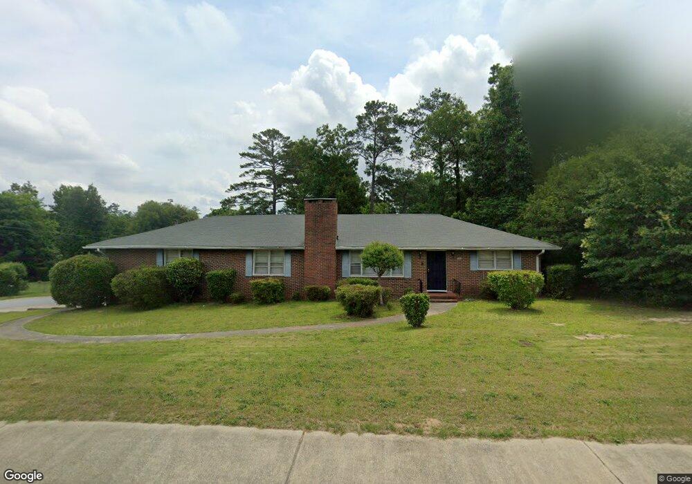
5064 Bloomfield Rd Macon, GA 31206
Estimated Value: $140,943 - $171,000
3
Beds
2
Baths
1,577
Sq Ft
$99/Sq Ft
Est. Value
About This Home
This home is located at 5064 Bloomfield Rd, Macon, GA 31206 and is currently estimated at $156,736, approximately $99 per square foot. 5064 Bloomfield Rd is a home located in Bibb County with nearby schools including Veterans Elementary School, Southwest High School, and Gilead Christian Academy.
Ownership History
Date
Name
Owned For
Owner Type
Purchase Details
Closed on
Mar 26, 2010
Sold by
Wood Tony
Bought by
Tw Property Holdings Llc
Current Estimated Value
Purchase Details
Closed on
Jun 26, 2009
Sold by
Household Realty Corporation
Bought by
Wood Tony
Purchase Details
Closed on
Mar 3, 2009
Sold by
Stanley Willie A and Stanley Daisy
Bought by
Household Realty Corporation
Create a Home Valuation Report for This Property
The Home Valuation Report is an in-depth analysis detailing your home's value as well as a comparison with similar homes in the area
Purchase History
| Date | Buyer | Sale Price | Title Company |
|---|---|---|---|
| Tw Property Holdings Llc | -- | None Available | |
| Wood Tony | $30,000 | None Available | |
| Household Realty Corporation | $31,978 | None Available |
Source: Public Records
Tax History
| Year | Tax Paid | Tax Assessment Tax Assessment Total Assessment is a certain percentage of the fair market value that is determined by local assessors to be the total taxable value of land and additions on the property. | Land | Improvement |
|---|---|---|---|---|
| 2025 | $1,113 | $45,273 | $2,400 | $42,873 |
| 2024 | $1,150 | $45,273 | $2,400 | $42,873 |
| 2023 | $1,150 | $45,273 | $2,400 | $42,873 |
| 2022 | $1,285 | $37,113 | $5,500 | $31,613 |
| 2021 | $1,410 | $37,113 | $5,500 | $31,613 |
| 2020 | $1,441 | $37,113 | $5,500 | $31,613 |
| 2019 | $1,453 | $37,113 | $5,500 | $31,613 |
| 2018 | $2,405 | $37,113 | $5,500 | $31,613 |
| 2017 | $1,390 | $37,113 | $5,500 | $31,613 |
| 2016 | $1,284 | $37,113 | $5,500 | $31,613 |
| 2015 | $1,817 | $37,113 | $5,500 | $31,613 |
| 2014 | $2,090 | $37,113 | $5,500 | $31,613 |
Source: Public Records
Map
Nearby Homes
- 3842 Wynnwood Dr
- 3913 Blair Ct
- 5060 Pinefield Dr
- 3266 Bloomfield Dr
- 4742 Bloomfield Rd
- 140 Spencer Hill Ct
- 5285 Greenwood Terrace
- 2545 Greenwood Terrace
- 3120 Bloomfield Dr
- 4500 Chambers Rd
- 165 Camden Trace
- 189 Camden Trace
- 120 Camden Trace
- 124 Camden Trace
- 3764 Walker Ave
- 3862 Gadson Dr
- 4941 Log Cabin Dr
- 3724 Johnson Ave W
- 106 Shiloh Ct
- 2970 Emerson Cir
- 5088 Bloomfield Rd
- 3867 Wynnwood Dr
- 3860 Wynnwood Dr
- 3859 Wynnwood Dr
- 5058 Bloomfield Rd
- 5104 Bloomfield Rd
- 3852 Wynnwood Dr
- 5071 Bloomfield Rd
- 3851 Wynnwood Dr
- 3881 Woodside Dr
- 5097 Bloomfield Rd
- 5114 Bloomfield Rd
- 3873 Woodside Dr
- 3843 Wynnwood Dr
- 5040 Bloomfield Rd
- 3834 Wynnwood Dr
- 5037 Bloomfield Rd
- 3835 Wynnwood Dr
- 3865 Woodside Dr
- 5125 Bloomfield Rd
Your Personal Tour Guide
Ask me questions while you tour the home.