Estimated Value: $159,000 - $201,000
--
Bed
1
Bath
1,630
Sq Ft
$108/Sq Ft
Est. Value
About This Home
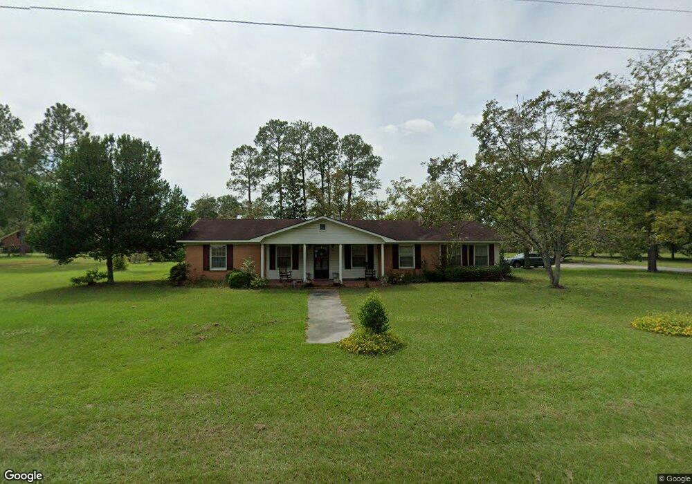
This home is located at 507 Radio Station Rd, Alma, GA 31510 and is currently estimated at $176,105, approximately $108 per square foot. 507 Radio Station Rd is a home located in Bacon County with nearby schools including Bacon County Primary School, Bacon County Elementary School, and Bacon County Middle School.
Ownership History
Date
Name
Owned For
Owner Type
Purchase Details
Closed on
Sep 28, 2017
Sold by
Tara L
Bought by
Sallet Julie Johnson
Current Estimated Value
Purchase Details
Closed on
Sep 27, 2017
Sold by
Johnson Carol Sue
Bought by
Sallet Julie Johnson and Drew Tara L
Purchase Details
Closed on
Oct 15, 2014
Sold by
Johnson Carol Sue
Bought by
Johnson Carol Sue and Johnson Ervin E
Home Financials for this Owner
Home Financials are based on the most recent Mortgage that was taken out on this home.
Original Mortgage
$148,500
Interest Rate
2.9%
Mortgage Type
Reverse Mortgage Home Equity Conversion Mortgage
Purchase Details
Closed on
Feb 5, 1995
Bought by
Johnson Carol Sue
Create a Home Valuation Report for This Property
The Home Valuation Report is an in-depth analysis detailing your home's value as well as a comparison with similar homes in the area
Home Values in the Area
Average Home Value in this Area
Purchase History
| Date | Buyer | Sale Price | Title Company |
|---|---|---|---|
| Sallet Julie Johnson | -- | -- | |
| Sallet Julie Johnson | -- | -- | |
| Johnson Carol Sue | -- | -- | |
| Johnson Carol Sue | -- | -- |
Source: Public Records
Mortgage History
| Date | Status | Borrower | Loan Amount |
|---|---|---|---|
| Previous Owner | Johnson Carol Sue | $148,500 |
Source: Public Records
Tax History Compared to Growth
Tax History
| Year | Tax Paid | Tax Assessment Tax Assessment Total Assessment is a certain percentage of the fair market value that is determined by local assessors to be the total taxable value of land and additions on the property. | Land | Improvement |
|---|---|---|---|---|
| 2024 | $1,862 | $51,240 | $5,640 | $45,600 |
| 2023 | $1,798 | $46,640 | $5,640 | $41,000 |
| 2022 | $1,323 | $34,320 | $5,640 | $28,680 |
| 2021 | $1,297 | $33,640 | $5,640 | $28,000 |
| 2020 | $1,211 | $30,054 | $5,152 | $24,902 |
| 2019 | $1,212 | $30,054 | $5,152 | $24,902 |
| 2018 | $1,222 | $30,370 | $5,152 | $25,218 |
| 2017 | $1,223 | $30,370 | $5,152 | $25,218 |
| 2016 | $1,018 | $30,370 | $5,152 | $25,218 |
| 2015 | $967 | $31,216 | $5,863 | $25,353 |
| 2014 | $967 | $31,216 | $5,863 | $25,353 |
| 2013 | $967 | $28,793 | $5,862 | $22,930 |
Source: Public Records
Map
Nearby Homes
- 611 S Bead St
- 403 S Ware St
- 117 Grace Loop Unit 1
- 118 Grace Loop Unit 1
- 122 Grace Loop Unit 1
- 9TH E 417
- 314 W 16th St
- 1348 U S 1
- 113 Brite Blue Dr
- 198 Meadow Rd
- 166 Grace Loop Unit 1
- 907 N Pierce St
- 0 Oriole Rd Unit 1654653
- 0 Oriole Rd Unit 10543585
- 0 Oriole Rd Unit 25773381
- 0 Oriole Rd Unit 160930
- 401 Lee St
- 224 Meadow Rd
- 118 Morris Dr
- 1109 W 4th Street Extension
- 510 Radio Station Rd
- 501 Radio Station Rd
- 511 Radio Station Rd
- 304 Crosby Rd
- 308 Crosby Rd
- 704 Townsend Ln
- 108 Mccrea Ave
- 310 Crosby Rd
- 706 Townsend Ln
- 603 Radio Station Rd
- 405 Radio Station Rd
- 305 Crosby Rd
- 107 Mccrea Ave
- 708 Townsend Ln
- 109 Mccrea Ave
- 202 Mccrea Ave
- 0 Townsend Ln
- 303 Crosby Rd
- 309 Crosby Rd
- 607 Radio Station Rd