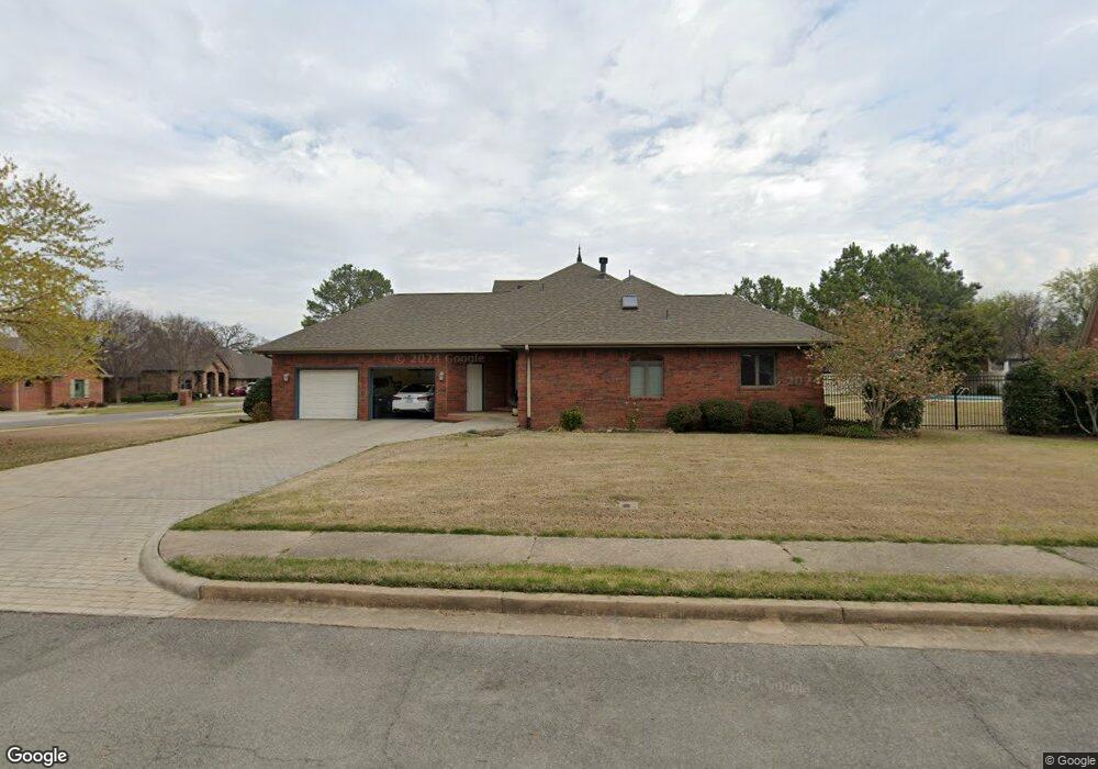
507 Ransten St Tahlequah, OK 74464
Estimated Value: $370,559 - $454,000
4
Beds
4
Baths
2,825
Sq Ft
$141/Sq Ft
Est. Value
About This Home
This home is located at 507 Ransten St, Tahlequah, OK 74464 and is currently estimated at $398,890, approximately $141 per square foot. 507 Ransten St is a home located in Cherokee County with nearby schools including Greenwood Elementary School, Cherokee Elementary School, and Tahlequah Middle School.
Ownership History
Date
Name
Owned For
Owner Type
Purchase Details
Closed on
Jan 5, 2012
Sold by
Wadley Joyce Louise and Wadley Joyce L
Bought by
Joyce Louise Wadley Trust
Current Estimated Value
Purchase Details
Closed on
Jul 15, 2011
Sold by
Buck Cynthia J and Buck Daryl E
Bought by
Wadley Joyce L
Purchase Details
Closed on
Oct 1, 2002
Sold by
Cynthia & Daryl Buck Tr
Bought by
Cynthia and Daryl Buck
Purchase Details
Closed on
Mar 23, 1995
Sold by
Invest. Vicki A and Invest. Younger
Bought by
Cynthia & Daryl Buck Tr
Create a Home Valuation Report for This Property
The Home Valuation Report is an in-depth analysis detailing your home's value as well as a comparison with similar homes in the area
Home Values in the Area
Average Home Value in this Area
Purchase History
| Date | Buyer | Sale Price | Title Company |
|---|---|---|---|
| Joyce Louise Wadley Trust | -- | None Available | |
| Wadley Joyce L | $295,000 | Heritage Title | |
| Cynthia | -- | -- | |
| Cynthia & Daryl Buck Tr | $18,000 | -- |
Source: Public Records
Tax History Compared to Growth
Tax History
| Year | Tax Paid | Tax Assessment Tax Assessment Total Assessment is a certain percentage of the fair market value that is determined by local assessors to be the total taxable value of land and additions on the property. | Land | Improvement |
|---|---|---|---|---|
| 2025 | $3,349 | $34,931 | $3,000 | $31,931 |
| 2024 | $3,349 | $35,344 | $3,000 | $32,344 |
| 2023 | $3,349 | $33,661 | $3,000 | $30,661 |
| 2022 | $3,123 | $33,661 | $3,000 | $30,661 |
| 2021 | $3,135 | $33,661 | $3,000 | $30,661 |
| 2020 | $3,191 | $33,660 | $3,000 | $30,660 |
| 2019 | $3,163 | $33,660 | $3,000 | $30,660 |
| 2018 | $3,263 | $34,329 | $3,000 | $31,329 |
| 2017 | $3,257 | $34,329 | $3,000 | $31,329 |
| 2016 | $3,388 | $35,487 | $3,000 | $32,487 |
| 2015 | $3,172 | $33,797 | $3,000 | $30,797 |
| 2014 | $3,055 | $32,450 | $3,000 | $29,450 |
Source: Public Records
Map
Nearby Homes
- 720 S East Ave
- 104 Tommye Ln
- 508 Garden Rd
- 605 S Oak Ave
- 200 Remington Place
- 508 Covington Place
- 103 S Harrison Ave
- 101 S Harrison Ave
- 725 Sooner Dr
- 0 S Hwy 82 A Hwy Unit 2532332
- 1005 Kaufman Ave
- 413 Greenwood Dr
- 111 N Logan Dr
- 215 S Maple Ave
- 281 Redbud Ln
- 403 S Bluff Ave
- 201 Sandy Cir
- 619 E Cherrie St
- 952 Edgewater
- 835 Blue Heron
- 505 Ransten St
- 509 Ransten St
- 508 Ransten Dr
- 514 Ransten St
- 508 Ransten St
- 510 Ransten St
- 511 Ransten St
- 506 Ransten St
- 512 Ransten St
- 508 S Cedar Place
- 706 E Ross St
- 506 S Cedar Place
- 510 S Cedar Place
- 512 S Cedar Place
- 712 E Ross St
- 514 S Cedar Place
- 507 Forest Ridge Dr
- 1150 E Ross St
- 516 S Cedar Place
- 502 Ransten St