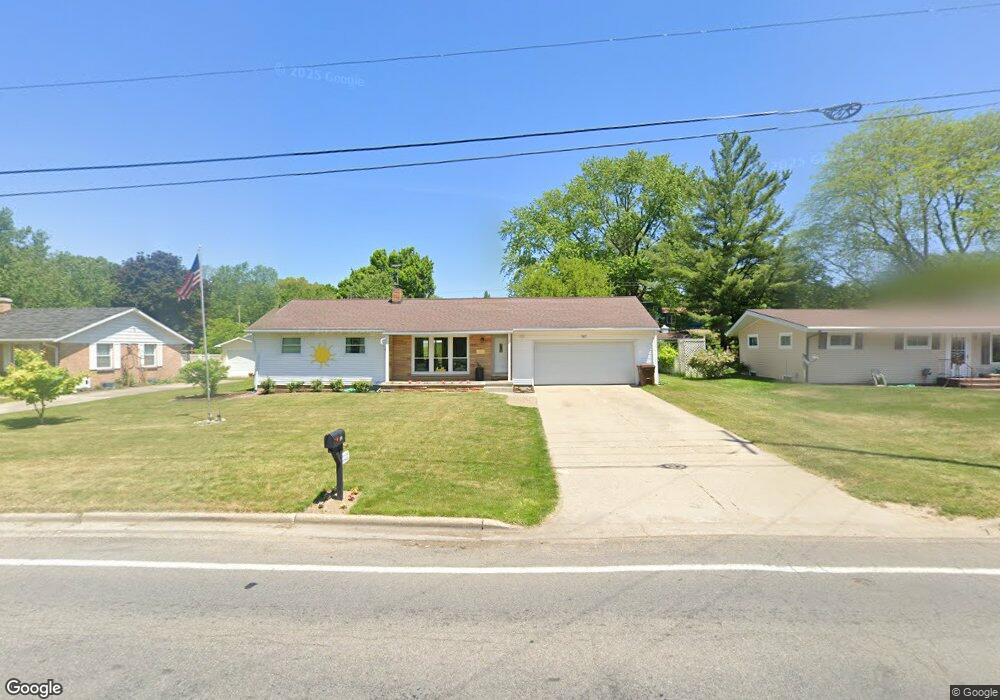
507 W State Rd Hastings, MI 49058
Estimated Value: $223,000 - $238,000
3
Beds
2
Baths
1,052
Sq Ft
$218/Sq Ft
Est. Value
About This Home
This home is located at 507 W State Rd, Hastings, MI 49058 and is currently estimated at $229,555, approximately $218 per square foot. 507 W State Rd is a home located in Barry County with nearby schools including Hastings High School and St. Rose of Lima School.
Ownership History
Date
Name
Owned For
Owner Type
Purchase Details
Closed on
Dec 10, 2015
Sold by
Homrich Richard and Homrich Linda L
Bought by
Homrich Family Trust
Current Estimated Value
Purchase Details
Closed on
Oct 10, 2013
Sold by
Winebrenner Ryan T and Winebrenner Jennifer
Bought by
Homrich Richard and Homrich Linda L
Purchase Details
Closed on
Mar 19, 2004
Sold by
Barnum Bruce H and Sheldon Jeralee K
Bought by
Weinbrenner Ryan T
Home Financials for this Owner
Home Financials are based on the most recent Mortgage that was taken out on this home.
Original Mortgage
$107,850
Interest Rate
5.74%
Mortgage Type
New Conventional
Create a Home Valuation Report for This Property
The Home Valuation Report is an in-depth analysis detailing your home's value as well as a comparison with similar homes in the area
Home Values in the Area
Average Home Value in this Area
Purchase History
| Date | Buyer | Sale Price | Title Company |
|---|---|---|---|
| Homrich Family Trust | -- | Attorney | |
| Homrich Richard | $100,000 | Bell Title Of Hastings | |
| Weinbrenner Ryan T | $105,000 | Metropolitan Title Company |
Source: Public Records
Mortgage History
| Date | Status | Borrower | Loan Amount |
|---|---|---|---|
| Previous Owner | Weinbrenner Ryan T | $107,850 |
Source: Public Records
Tax History
| Year | Tax Paid | Tax Assessment Tax Assessment Total Assessment is a certain percentage of the fair market value that is determined by local assessors to be the total taxable value of land and additions on the property. | Land | Improvement |
|---|---|---|---|---|
| 2025 | $2,266 | $86,200 | $0 | $0 |
| 2024 | $2,266 | $79,600 | $0 | $0 |
| 2023 | $2,087 | $70,300 | $0 | $0 |
| 2022 | $2,087 | $70,300 | $0 | $0 |
| 2020 | $2,087 | $59,500 | $0 | $0 |
| 2019 | $2,087 | $54,500 | $0 | $0 |
| 2018 | $0 | $49,600 | $0 | $0 |
| 2017 | $0 | $50,600 | $0 | $0 |
| 2016 | -- | $48,400 | $0 | $0 |
| 2015 | -- | $47,200 | $0 | $0 |
| 2014 | -- | $47,200 | $0 | $0 |
Source: Public Records
Map
Nearby Homes
- 817 N Glenwood St
- 907 N Glenwood Dr
- 348 W State Rd
- 812 N Church St
- V/L S M 43 Hwy
- 227 W Benson St
- 709 N Michigan Ave
- 703 W Woodlawn Ave Unit 1
- 1520 Liberty Ln
- 502 W State St
- 203 E High St
- 1532 Liberty Ln
- 1107 N Michigan Ave
- 202 E Thorn St
- 1310 N Boltwood St Unit 6
- 222 E Mill St
- 270 Michigan 37
- 364 Michigan 37
- 517 E State Rd
- 521 E State Rd
- 515 W State Rd
- 501 W State Rd
- 522 W Colfax St
- 502 W Colfax St
- 719 N Glenwood Dr
- 528 N Monroe St
- 525 N Monroe St
- 706 N Glenwood St
- 711 N Hillcrest Dr
- 706 N Glenwood Dr
- 520 W State Rd
- 446 W Colfax St
- 520 N Monroe St
- 517 N Monroe St
- 718 N Glenwood Dr
- 431 W State Rd
- 436 W Colfax St
- 517 W Colfax St
- 605 W State Rd
- 518 N Congress St
Your Personal Tour Guide
Ask me questions while you tour the home.