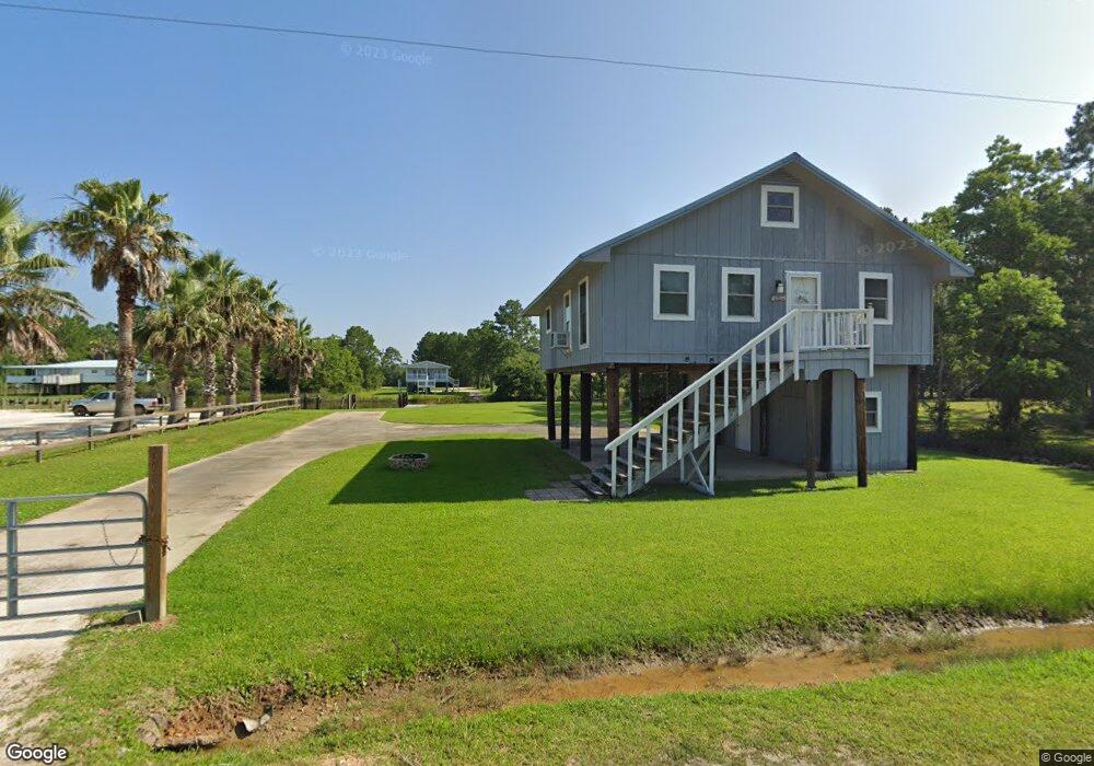
5070 Green Dr W Coden, AL 36523
Heron Bay NeighborhoodEstimated Value: $188,488 - $229,000
2
Beds
1
Bath
1,200
Sq Ft
$172/Sq Ft
Est. Value
About This Home
This home is located at 5070 Green Dr W, Coden, AL 36523 and is currently estimated at $206,872, approximately $172 per square foot. 5070 Green Dr W is a home located in Mobile County with nearby schools including Anna F. Booth Elementary School, Alba Middle School, and Alma Bryant High School.
Ownership History
Date
Name
Owned For
Owner Type
Purchase Details
Closed on
Sep 9, 2013
Sold by
Murphy Robert
Bought by
Murphy Brian and Murphy Lori Ann
Current Estimated Value
Purchase Details
Closed on
Aug 10, 2006
Sold by
Evans Ronnie J
Bought by
Murphy Robert
Home Financials for this Owner
Home Financials are based on the most recent Mortgage that was taken out on this home.
Original Mortgage
$92,380
Interest Rate
6.67%
Mortgage Type
Purchase Money Mortgage
Purchase Details
Closed on
Jan 19, 2005
Sold by
Daniel Joyce J
Bought by
Evans Ronnie J and Orr Emogene J
Create a Home Valuation Report for This Property
The Home Valuation Report is an in-depth analysis detailing your home's value as well as a comparison with similar homes in the area
Home Values in the Area
Average Home Value in this Area
Purchase History
| Date | Buyer | Sale Price | Title Company |
|---|---|---|---|
| Murphy Brian | $84,000 | None Available | |
| Murphy Robert | $115,475 | None Available | |
| Evans Ronnie J | -- | -- |
Source: Public Records
Mortgage History
| Date | Status | Borrower | Loan Amount |
|---|---|---|---|
| Previous Owner | Murphy Robert | $92,380 |
Source: Public Records
Tax History
| Year | Tax Paid | Tax Assessment Tax Assessment Total Assessment is a certain percentage of the fair market value that is determined by local assessors to be the total taxable value of land and additions on the property. | Land | Improvement |
|---|---|---|---|---|
| 2025 | $1,216 | $24,360 | $11,200 | $13,160 |
| 2024 | $1,216 | $24,460 | $11,300 | $13,160 |
| 2023 | $1,221 | $19,320 | $8,000 | $11,320 |
| 2022 | $972 | $19,320 | $8,000 | $11,320 |
| 2021 | $967 | $19,940 | $6,800 | $13,140 |
| 2020 | $914 | $18,120 | $6,800 | $11,320 |
| 2019 | $826 | $16,300 | $6,800 | $9,500 |
| 2018 | $772 | $15,920 | $0 | $0 |
| 2017 | $807 | $15,920 | $0 | $0 |
| 2016 | $756 | $15,580 | $0 | $0 |
| 2013 | $475 | $9,480 | $0 | $0 |
Source: Public Records
Map
Nearby Homes
- 4455 Heron Bay Loop Rd S
- 0 Highway 188 Unit 7708364
- 0 Highway 188 Unit 7087950
- 0 Highway 188 Unit 7087940
- 000 Johnson Rd
- 0 Johnson Rd
- 0 Bellingrath Rd Unit 17356630
- 3881 Oregon Ave
- 16045 Williams St Unit 1
- 16045 Williams St
- 3937 Alabama St
- 0 Oregon Ave Unit 7616840
- 0 Oregon Ave Unit 7716702
- 3739 Washington Rd
- 0 Washington Ave
- 0 Bayou Shores Dr Unit 389041
- 0 Bayou Shores Dr Unit 7496968
- 14165 River Oaks Dr
- 14165 River Oaks Dr Unit A & B
- 0 Michigan Ave Unit 7667677
- 5081 Morris Dr E
- 5051 Morris Dr E
- 3 Green Dr
- 5060 Morris Dr W
- 5041 Morris Dr
- 5021 Morris Dr
- 5040 Morris Dr E
- 4971 Morris Dr W
- 4970 Green Dr W
- 4960 Green Dr W
- 4961 Morris Dr W
- 15395 Mcgraw Blvd
- 15385 Mcgraw Blvd Unit 111
- 15441 Morris Dr
- 15420 Morris Dr
- 15373 Mcgraw Blvd Unit 110
- 15431 Morris Dr
- 15421 Morris Dr
- 15390 Morris Dr
- 15411 Morris Dr
Your Personal Tour Guide
Ask me questions while you tour the home.