Estimated Value: $424,605 - $454,000
4
Beds
2
Baths
2,000
Sq Ft
$220/Sq Ft
Est. Value
About This Home
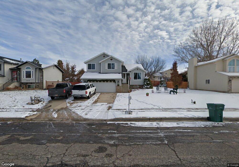
This home is located at 5070 S 3025 W, Roy, UT 84067 and is currently estimated at $440,651, approximately $220 per square foot. 5070 S 3025 W is a home located in Weber County with nearby schools including Midland School, Sand Ridge Junior High School, and Roy High School.
Ownership History
Date
Name
Owned For
Owner Type
Purchase Details
Closed on
Jun 1, 2005
Sold by
Cendant Mobility Financial Corp
Bought by
Falcon Eva G
Current Estimated Value
Home Financials for this Owner
Home Financials are based on the most recent Mortgage that was taken out on this home.
Original Mortgage
$135,850
Interest Rate
8.85%
Mortgage Type
Fannie Mae Freddie Mac
Purchase Details
Closed on
Apr 21, 2005
Sold by
Davis Matthew W
Bought by
Cendant Mobility Financial Corp
Home Financials for this Owner
Home Financials are based on the most recent Mortgage that was taken out on this home.
Original Mortgage
$135,850
Interest Rate
8.85%
Mortgage Type
Fannie Mae Freddie Mac
Purchase Details
Closed on
Jan 31, 2001
Sold by
Harrington Scott A and Harrington Barbara
Bought by
Davis Matthew W
Home Financials for this Owner
Home Financials are based on the most recent Mortgage that was taken out on this home.
Original Mortgage
$141,775
Interest Rate
7.13%
Mortgage Type
FHA
Create a Home Valuation Report for This Property
The Home Valuation Report is an in-depth analysis detailing your home's value as well as a comparison with similar homes in the area
Home Values in the Area
Average Home Value in this Area
Purchase History
| Date | Buyer | Sale Price | Title Company |
|---|---|---|---|
| Falcon Eva G | -- | Inwest Title Ogden | |
| Cendant Mobility Financial Corp | -- | Inwest Title Ogden | |
| Davis Matthew W | -- | -- |
Source: Public Records
Mortgage History
| Date | Status | Borrower | Loan Amount |
|---|---|---|---|
| Previous Owner | Falcon Eva G | $135,850 | |
| Previous Owner | Davis Matthew W | $141,775 |
Source: Public Records
Tax History Compared to Growth
Tax History
| Year | Tax Paid | Tax Assessment Tax Assessment Total Assessment is a certain percentage of the fair market value that is determined by local assessors to be the total taxable value of land and additions on the property. | Land | Improvement |
|---|---|---|---|---|
| 2025 | $2,678 | $425,649 | $131,826 | $293,823 |
| 2024 | $2,566 | $225,499 | $72,504 | $152,995 |
| 2023 | $2,430 | $213,400 | $66,315 | $147,085 |
| 2022 | $2,666 | $243,100 | $55,604 | $187,496 |
| 2021 | $2,101 | $313,000 | $75,808 | $237,192 |
| 2020 | $1,987 | $272,000 | $75,808 | $196,192 |
| 2019 | $1,890 | $243,000 | $45,669 | $197,331 |
| 2018 | $1,796 | $217,000 | $45,669 | $171,331 |
| 2017 | $1,643 | $185,000 | $45,669 | $139,331 |
| 2016 | $1,664 | $101,397 | $22,192 | $79,205 |
| 2015 | $1,424 | $87,672 | $22,192 | $65,480 |
| 2014 | $1,437 | $87,672 | $22,192 | $65,480 |
Source: Public Records
Map
Nearby Homes