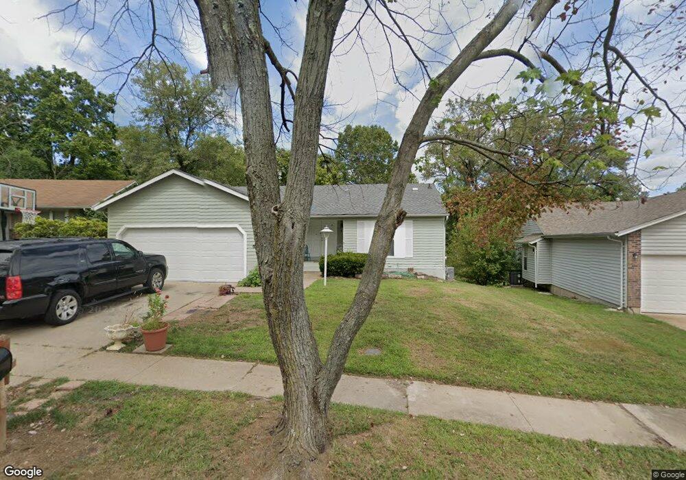
5071 Trailbend Dr Florissant, MO 63033
Estimated Value: $146,000 - $190,821
3
Beds
2
Baths
1,022
Sq Ft
$167/Sq Ft
Est. Value
About This Home
This home is located at 5071 Trailbend Dr, Florissant, MO 63033 and is currently estimated at $170,955, approximately $167 per square foot. 5071 Trailbend Dr is a home located in St. Louis County with nearby schools including Jamestown Elementary School, Central Middle School, and Hazelwood Central High School.
Ownership History
Date
Name
Owned For
Owner Type
Purchase Details
Closed on
Apr 14, 2014
Sold by
Osaka Homes Llc
Bought by
Sa Ventures Llc
Current Estimated Value
Purchase Details
Closed on
Jun 26, 2012
Sold by
Fannie Mae
Bought by
Osaka Real Estate Llc
Purchase Details
Closed on
May 8, 2012
Sold by
Deskins Angela Knight
Bought by
Federal National Mortgage Association
Create a Home Valuation Report for This Property
The Home Valuation Report is an in-depth analysis detailing your home's value as well as a comparison with similar homes in the area
Home Values in the Area
Average Home Value in this Area
Purchase History
| Date | Buyer | Sale Price | Title Company |
|---|---|---|---|
| Sa Ventures Llc | -- | Orntic St Louis | |
| Osaka Real Estate Llc | $41,001 | None Available | |
| Federal National Mortgage Association | $41,960 | None Available |
Source: Public Records
Tax History Compared to Growth
Tax History
| Year | Tax Paid | Tax Assessment Tax Assessment Total Assessment is a certain percentage of the fair market value that is determined by local assessors to be the total taxable value of land and additions on the property. | Land | Improvement |
|---|---|---|---|---|
| 2025 | $2,697 | $35,280 | $5,050 | $30,230 |
| 2024 | $2,697 | $29,900 | $5,050 | $24,850 |
| 2023 | $2,691 | $29,900 | $5,050 | $24,850 |
| 2022 | $2,530 | $23,940 | $5,890 | $18,050 |
| 2021 | $2,420 | $23,940 | $5,890 | $18,050 |
| 2020 | $2,286 | $21,360 | $3,880 | $17,480 |
| 2019 | $2,255 | $21,360 | $3,880 | $17,480 |
| 2018 | $2,020 | $17,670 | $2,680 | $14,990 |
| 2017 | $2,018 | $17,670 | $2,680 | $14,990 |
| 2016 | $1,812 | $15,580 | $3,020 | $12,560 |
| 2015 | $1,771 | $15,580 | $3,020 | $12,560 |
| 2014 | $1,562 | $13,660 | $3,340 | $10,320 |
Source: Public Records
Map
Nearby Homes
- 5226 Suntrail Dr
- 12582 Springtrail Dr
- 12991 Mourville Ct
- 5239 Trailoaks Dr
- 5432 Trailbend Dr
- 5348 Trailoaks Dr
- 12292 Jerries Ln
- 13001 Kinsley Heights Dr
- 13032 Kinsley Heights Dr
- 13107 Ambrose Ct
- 4847 Trees Edge Ln
- 4846 Trees Edge Ln
- 13145 Crestwood Bend Ln
- 12705 Stubwood Dr
- 13141 Crestwood Bend Ln
- 13125 Crestwood Bend Ln
- 13144 Crestwood Bend Ln
- 12320 Missile Ln
- 13140 Crestwood Bend Ln
- 4874 Trees Edge Ln
- 5061 Trailbend Dr
- 5081 Trailbend Dr
- 5091 Trailbend Dr
- 5051 Trailbend Dr
- 5062 Trailbend Dr
- 5072 Trailbend Dr
- 5101 Trailbend Dr
- 5052 Trailbend Dr
- 5031 Trailbend Dr
- 12392 Trailforest Ln
- 12371 Trailforest Ln
- 5042 Trailbend Dr
- 5080 Wolverton Dr
- 5060 Wolverton Dr
- 5021 Trailbend Dr
- 12382 Trailforest Ln
- 5090 Wolverton Dr
- 5032 Trailbend Dr
- 12361 Trailforest Ln
- 5022 Trailbend Dr