Estimated Value: $346,000 - $371,000
4
Beds
3
Baths
2,000
Sq Ft
$181/Sq Ft
Est. Value
About This Home
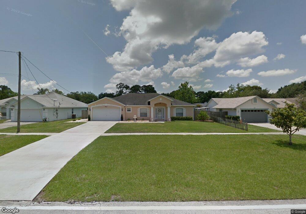
This home is located at 5075 Curtis Blvd, Cocoa, FL 32927 and is currently estimated at $362,185, approximately $181 per square foot. 5075 Curtis Blvd is a home located in Brevard County with nearby schools including Challenger 7 Elementary School, Space Coast Junior/Senior High School, and Sculptor Charter School.
Ownership History
Date
Name
Owned For
Owner Type
Purchase Details
Closed on
May 5, 2005
Sold by
Holiday Builders Inc
Bought by
Elosge Albert P and Elosge Analee S
Current Estimated Value
Home Financials for this Owner
Home Financials are based on the most recent Mortgage that was taken out on this home.
Original Mortgage
$100,000
Outstanding Balance
$50,558
Interest Rate
5.37%
Estimated Equity
$311,627
Purchase Details
Closed on
Dec 11, 2002
Sold by
Wulf Krell Dawn M
Bought by
Laschober Gerald R
Purchase Details
Closed on
Jul 26, 2002
Sold by
Mills Charles L and Mills Karen S
Bought by
Krell Dawn M Wulf
Create a Home Valuation Report for This Property
The Home Valuation Report is an in-depth analysis detailing your home's value as well as a comparison with similar homes in the area
Home Values in the Area
Average Home Value in this Area
Purchase History
| Date | Buyer | Sale Price | Title Company |
|---|---|---|---|
| Elosge Albert P | $175,700 | Hbi Title Company | |
| Laschober Gerald R | $18,000 | -- | |
| Krell Dawn M Wulf | $17,500 | -- |
Source: Public Records
Mortgage History
| Date | Status | Borrower | Loan Amount |
|---|---|---|---|
| Open | Elosge Albert P | $100,000 |
Source: Public Records
Tax History Compared to Growth
Tax History
| Year | Tax Paid | Tax Assessment Tax Assessment Total Assessment is a certain percentage of the fair market value that is determined by local assessors to be the total taxable value of land and additions on the property. | Land | Improvement |
|---|---|---|---|---|
| 2025 | $1,664 | $117,780 | -- | -- |
| 2024 | $1,624 | $114,470 | -- | -- |
| 2023 | $1,624 | $111,140 | $0 | $0 |
| 2022 | $1,517 | $107,910 | $0 | $0 |
| 2021 | $1,519 | $104,770 | $0 | $0 |
| 2020 | $1,444 | $103,330 | $0 | $0 |
| 2019 | $1,380 | $101,010 | $0 | $0 |
| 2018 | $1,373 | $99,130 | $0 | $0 |
| 2017 | $1,366 | $97,100 | $0 | $0 |
| 2016 | $1,370 | $95,110 | $18,000 | $77,110 |
| 2015 | $1,388 | $94,450 | $15,000 | $79,450 |
| 2014 | $1,390 | $93,700 | $11,000 | $82,700 |
Source: Public Records
Map
Nearby Homes
- 6735 Grissom Pkwy
- 6840 Anecia Ave
- 5090 Market St
- 5149 Arlington Rd Unit 104
- 0000 Grissom Pkwy
- 5155 Mayflower St
- 00 Unknown
- 6375 Cable Ave
- 7155 Export Ave
- 6615 Dock Ave
- 6390 Depot Ave
- 4760 Ivan St
- 7065 Hundred Acre Dr
- 4635 Alfred St
- 7035 Jasmine Ave
- 5145 Fay Blvd
- 4859 Horton St
- 4975 Fay Blvd
- 5265 Fay Blvd
- 6240 Grissom Pkwy
- 5085 Curtis Blvd
- 5065 Curtis Blvd
- 5070 Hogan Place
- 5060 Hogan Place
- 5105 Curtis Blvd
- 5080 Hogan Place
- 5050 Hogan Place
- 5070 Curtis Blvd
- 5080 Curtis Blvd
- 5090 Hogan Place
- 5115 Curtis Blvd
- 5060 Curtis Blvd
- 5090 Curtis Blvd
- 5050 Curtis Blvd
- 5100 Hogan Place
- 5055 Hogan Place
- 5100 Curtis Blvd
- 5125 Curtis Blvd
- 5075 Hogan Place
- 6745 Corto Rd