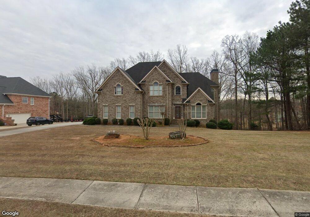
508 Saint Sambar Dr Ellenwood, GA 30294
Estimated Value: $516,871 - $692,000
4
Beds
4
Baths
2,761
Sq Ft
$226/Sq Ft
Est. Value
About This Home
This home is located at 508 Saint Sambar Dr, Ellenwood, GA 30294 and is currently estimated at $624,218, approximately $226 per square foot. 508 Saint Sambar Dr is a home located in Henry County with nearby schools including Austin Road Elementary School, Austin Road Middle School, and Woodland High School.
Ownership History
Date
Name
Owned For
Owner Type
Purchase Details
Closed on
Sep 28, 2009
Sold by
Mlmi Trust 2007-He1
Bought by
Bakare George
Current Estimated Value
Purchase Details
Closed on
Aug 4, 2009
Sold by
Hodges Kenneth E and Hodges Kimberly P
Bought by
Mlmi Trust Series 2007-He1
Purchase Details
Closed on
Feb 16, 2006
Sold by
Hodges Kenneth E
Bought by
Hodges Kenneth E and Hodges Kimberly P
Home Financials for this Owner
Home Financials are based on the most recent Mortgage that was taken out on this home.
Original Mortgage
$363,900
Interest Rate
6.04%
Mortgage Type
New Conventional
Create a Home Valuation Report for This Property
The Home Valuation Report is an in-depth analysis detailing your home's value as well as a comparison with similar homes in the area
Home Values in the Area
Average Home Value in this Area
Purchase History
| Date | Buyer | Sale Price | Title Company |
|---|---|---|---|
| Bakare George | $245,000 | -- | |
| Mlmi Trust Series 2007-He1 | $208,986 | -- | |
| Hodges Kenneth E | -- | -- | |
| Hodges Kenneth E | $454,900 | -- |
Source: Public Records
Mortgage History
| Date | Status | Borrower | Loan Amount |
|---|---|---|---|
| Previous Owner | Hodges Kenneth E | $363,900 | |
| Previous Owner | Hodges Kenneth E | $90,950 |
Source: Public Records
Tax History Compared to Growth
Tax History
| Year | Tax Paid | Tax Assessment Tax Assessment Total Assessment is a certain percentage of the fair market value that is determined by local assessors to be the total taxable value of land and additions on the property. | Land | Improvement |
|---|---|---|---|---|
| 2025 | $9,410 | $235,920 | $20,000 | $215,920 |
| 2024 | $9,410 | $216,160 | $20,000 | $196,160 |
| 2023 | $7,821 | $201,720 | $18,000 | $183,720 |
| 2022 | $6,411 | $164,960 | $18,000 | $146,960 |
| 2021 | $5,552 | $142,560 | $18,000 | $124,560 |
| 2020 | $5,493 | $141,040 | $12,000 | $129,040 |
| 2019 | $5,363 | $137,640 | $12,000 | $125,640 |
| 2018 | $5,232 | $134,240 | $12,000 | $122,240 |
| 2016 | $4,591 | $117,520 | $10,000 | $107,520 |
| 2015 | $3,688 | $91,160 | $10,000 | $81,160 |
| 2014 | $3,650 | $89,120 | $10,000 | $79,120 |
Source: Public Records
Map
Nearby Homes
- 500 Saint Sambar Dr
- 429 Saint Surrey Way
- 160 Chapel Ridge Dr
- 168 Chapel Ridge Dr
- 565 Scarborough Rd
- 0 Kingsbrook Dr Unit 19 LOTS 10399843
- 444 Cauthen Ct
- 116 Kalsum Trail
- 963 Blackberry Ct
- 907 Strawberry Ct
- 1414 Panola Rd
- 176 Fairoaks Cir
- 107 S Circle Dr
- 4241 Hearn Rd
- 270 Huckleberry Ln
- 103 N Circle Dr
- 204 Benefield Ct
- 313 Ashborough Place
- 4923 Amsler Rd
- 106 Garden Trail
- 504 Saint Sambar Dr
- 512 Saint Sambar Dr Unit 2
- 501 Saint Sambar Dr Unit 2/102
- 501 Saint Sambar Dr
- 601 Saint Christopher Ln
- 409 Saint Surrey Way Unit 64
- 409 Saint Surrey Way Unit 2/64
- 516 Saint Sambar Dr
- 405 Saint Surrey Way Unit 58
- 405 Saint Surrey Way Unit 65
- 405 Saint Surrey Way
- 413 Saint Surrey Way Unit 63
- 413 Saint Surrey Way
- 505 Saint Sambar Dr Unit 2
- 0 Saint Sambar Dr Unit 7363804
- 0 Saint Sambar Dr Unit 10121295
- 0 Saint Sambar Dr Unit 7161416
- 417 Saint Surrey Way
- 417 Saint Surrey Way Unit 62
- 401 Saint Surrey Way