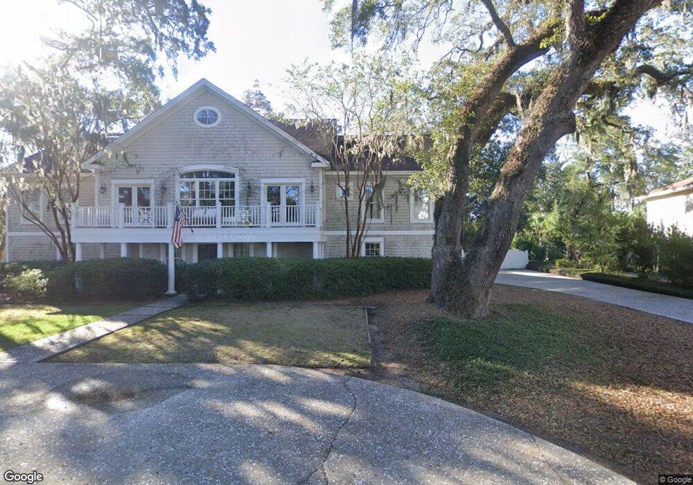
508 Vassar Point Dr Saint Simons Island, GA 31522
Estimated Value: $927,145 - $1,202,000
3
Beds
4
Baths
2,736
Sq Ft
$403/Sq Ft
Est. Value
About This Home
This home is located at 508 Vassar Point Dr, Saint Simons Island, GA 31522 and is currently estimated at $1,103,286, approximately $403 per square foot. 508 Vassar Point Dr is a home located in Glynn County with nearby schools including St. Simons Elementary School, Glynn Middle School, and Glynn Academy.
Ownership History
Date
Name
Owned For
Owner Type
Purchase Details
Closed on
Oct 19, 2006
Sold by
Gash Thomas L
Bought by
Gash Thomas L and Gash Gloria
Current Estimated Value
Purchase Details
Closed on
Sep 15, 2006
Sold by
Philips Hayes M
Bought by
Gash Thomas L
Create a Home Valuation Report for This Property
The Home Valuation Report is an in-depth analysis detailing your home's value as well as a comparison with similar homes in the area
Home Values in the Area
Average Home Value in this Area
Purchase History
| Date | Buyer | Sale Price | Title Company |
|---|---|---|---|
| Gash Thomas L | -- | -- | |
| Gash Thomas L | $660,000 | -- |
Source: Public Records
Tax History Compared to Growth
Tax History
| Year | Tax Paid | Tax Assessment Tax Assessment Total Assessment is a certain percentage of the fair market value that is determined by local assessors to be the total taxable value of land and additions on the property. | Land | Improvement |
|---|---|---|---|---|
| 2025 | $7,690 | $306,640 | $76,680 | $229,960 |
| 2024 | $6,382 | $254,480 | $68,160 | $186,320 |
| 2023 | $1,592 | $254,480 | $68,160 | $186,320 |
| 2022 | $1,742 | $193,040 | $61,360 | $131,680 |
| 2021 | $1,789 | $189,520 | $61,360 | $128,160 |
| 2020 | $1,832 | $189,520 | $61,360 | $128,160 |
| 2019 | $1,832 | $189,520 | $61,360 | $128,160 |
| 2018 | $1,832 | $189,520 | $61,360 | $128,160 |
| 2017 | $1,832 | $189,520 | $61,360 | $128,160 |
| 2016 | $1,470 | $189,520 | $61,360 | $128,160 |
| 2015 | $1,470 | $189,520 | $61,360 | $128,160 |
| 2014 | $1,470 | $189,520 | $61,360 | $128,160 |
Source: Public Records
Map
Nearby Homes
- 295 Mcintosh Ave
- 242 Mcintosh Ave
- 211 Mcintosh Ave
- 121 Killgriffe St
- 524 Wesley Oak Cir
- 202 Vassar Point Dr
- 516 Postell Dr
- 2404 Frederica Rd
- 104 Youngwood Dr
- 207 Military Rd
- 210 Settlers Rd
- 10 Fern Ln
- 50 Frederica Oaks Ln
- 135 Stewart St
- 214 Hermitage Way
- 240 Peachtree St
- 105 Ledbetter Ave
- 239 Broadway St
- 238 Broadway St
- 303 Wymberly Rd
- 510 Vassar Point Dr
- 512 Vassar Point Dr
- 116 Strother Place
- 275 Mcintosh Ave
- 122 Strother Place
- 507 Vassar Point Dr
- 514 Vassar Point Dr
- 112 Strother Place
- 18 Strother Place
- 504 Vassar Point Dr
- 267 Mcintosh Ave
- 281 Mcintosh Ave
- 507 Vassar Point
- Lot 12 Strother Place
- 259 Mcintosh Ave
- 128 Strother Place
- 505 Vassar Point Dr
- 509 Vassar Point Dr
- Lot16 Strother Place
- 115 Strother Place