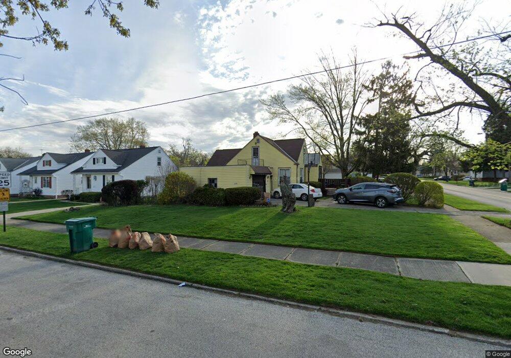
5081 Philip Ave Maple Heights, OH 44137
Estimated Value: $116,000 - $138,000
4
Beds
1
Bath
1,288
Sq Ft
$97/Sq Ft
Est. Value
About This Home
This home is located at 5081 Philip Ave, Maple Heights, OH 44137 and is currently estimated at $125,497, approximately $97 per square foot. 5081 Philip Ave is a home located in Cuyahoga County with nearby schools including Abraham Lincoln Elementary School, Rockside/ J.F. Kennedy School, and Italy High School.
Ownership History
Date
Name
Owned For
Owner Type
Purchase Details
Closed on
May 7, 1993
Sold by
Fleck Bruce A
Bought by
Turner Jacqueline W
Current Estimated Value
Purchase Details
Closed on
Aug 20, 1976
Sold by
Wood Richard H and Wood Phyllis T
Bought by
Fleck Bruce A
Purchase Details
Closed on
Jan 1, 1975
Bought by
Wood Richard H and Wood Phyllis T
Create a Home Valuation Report for This Property
The Home Valuation Report is an in-depth analysis detailing your home's value as well as a comparison with similar homes in the area
Home Values in the Area
Average Home Value in this Area
Purchase History
| Date | Buyer | Sale Price | Title Company |
|---|---|---|---|
| Turner Jacqueline W | $65,000 | -- | |
| Fleck Bruce A | $30,000 | -- | |
| Wood Richard H | -- | -- |
Source: Public Records
Tax History Compared to Growth
Tax History
| Year | Tax Paid | Tax Assessment Tax Assessment Total Assessment is a certain percentage of the fair market value that is determined by local assessors to be the total taxable value of land and additions on the property. | Land | Improvement |
|---|---|---|---|---|
| 2024 | $3,088 | $32,235 | $10,710 | $21,525 |
| 2023 | $2,143 | $18,210 | $6,480 | $11,730 |
| 2022 | $2,136 | $18,200 | $6,480 | $11,730 |
| 2021 | $2,263 | $18,200 | $6,480 | $11,730 |
| 2020 | $1,962 | $13,790 | $4,900 | $8,890 |
| 2019 | $1,941 | $39,400 | $14,000 | $25,400 |
| 2018 | $1,973 | $13,790 | $4,900 | $8,890 |
| 2017 | $2,180 | $15,790 | $4,550 | $11,240 |
| 2016 | $2,101 | $15,790 | $4,550 | $11,240 |
| 2015 | $2,093 | $15,790 | $4,550 | $11,240 |
| 2014 | $2,093 | $17,370 | $5,010 | $12,360 |
Source: Public Records
Map
Nearby Homes
- 5110 Philip Ave
- 5061 Philip Ave
- 5082 Philip Ave
- 5031 Cato St
- 5185 Clement Ave
- 5231 Philip Ave
- 5199 Arch St
- 5208 Clement Ave
- 5257 Philip Ave
- 5239 Arch St
- 5212 Catherine St
- 5234 Erwin St
- 5320 Clement Ave
- 5210 Theodore St
- 16712 Kollin Ave
- 17916 North Blvd
- 17912 North Blvd
- 17806 Maple Heights Blvd
- 17204 Maple Heights Blvd
- 16241 Glenburn Ave
- 5073 Philip Ave
- 5082 Thomas St
- 5107 Philip Ave
- 5078 Thomas St
- 5074 Thomas St
- 5065 Philip Ave
- 5100 Thomas St
- 5070 Thomas St
- 5111 Philip Ave
- 5082 Phiip St
- 5078 Philip Ave
- 5110 Thomas St
- 5074 Philip Ave
- 5066 Thomas St
- 5100 Philip Ave
- 5115 Philip Ave
- 5070 Philip Ave
- 5108 Philip Ave
- 5062 Thomas St
- 5057 Philip Ave