Estimated Value: $72,870 - $121,000
3
Beds
1
Bath
884
Sq Ft
$109/Sq Ft
Est. Value
About This Home
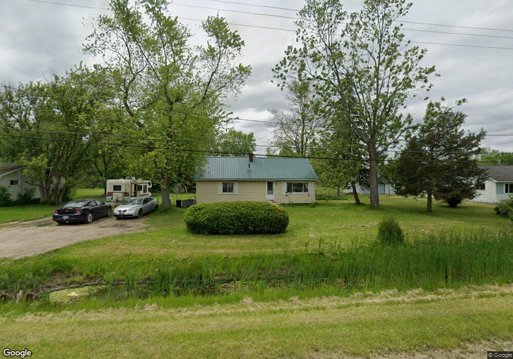
This home is located at 5085 W Coldwater Rd, Flint, MI 48504 and is currently estimated at $96,718, approximately $109 per square foot. 5085 W Coldwater Rd is a home located in Genesee County with nearby schools including Col. Donald McMonagle Elementary School, Hamady Community Middle/High School, and Northridge Academy.
Ownership History
Date
Name
Owned For
Owner Type
Purchase Details
Closed on
Jun 10, 2020
Sold by
Genesee County Land Bank Authority
Bought by
Casteel Teresa Stephanie
Current Estimated Value
Purchase Details
Closed on
Feb 27, 2012
Sold by
The Genesee County Land Bank Authority
Bought by
Casteel Teresa Stephanie
Purchase Details
Closed on
Dec 21, 2011
Sold by
Genesee County Treasurer
Bought by
Genesee County Land Bank
Purchase Details
Closed on
Aug 29, 2008
Sold by
Blue Spruce Entities Llc
Bought by
Go Invest Wisely Llc
Purchase Details
Closed on
Oct 10, 2007
Sold by
Minge Shari A
Bought by
Wells Fargo Bank Na and Securitized Asset Backed Receivables Llc
Purchase Details
Closed on
Aug 29, 2004
Sold by
Minge Bobie L and Minge Leah
Bought by
Minge Shari A
Create a Home Valuation Report for This Property
The Home Valuation Report is an in-depth analysis detailing your home's value as well as a comparison with similar homes in the area
Home Values in the Area
Average Home Value in this Area
Purchase History
| Date | Buyer | Sale Price | Title Company |
|---|---|---|---|
| Casteel Teresa Stephanie | $16,200 | None Available | |
| Casteel Teresa Stephanie | $16,200 | None Available | |
| Genesee County Land Bank | -- | None Available | |
| Go Invest Wisely Llc | -- | None Available | |
| Blue Spruce Entities Llc | -- | None Available | |
| Wells Fargo Bank Na | $55,250 | None Available | |
| Minge Shari A | -- | -- |
Source: Public Records
Mortgage History
| Date | Status | Borrower | Loan Amount |
|---|---|---|---|
| Closed | Casteel Teresa Stephanie | $0 |
Source: Public Records
Tax History Compared to Growth
Tax History
| Year | Tax Paid | Tax Assessment Tax Assessment Total Assessment is a certain percentage of the fair market value that is determined by local assessors to be the total taxable value of land and additions on the property. | Land | Improvement |
|---|---|---|---|---|
| 2025 | $1,133 | $32,200 | $0 | $0 |
| 2024 | $261 | $31,800 | $0 | $0 |
| 2023 | $249 | $27,600 | $0 | $0 |
| 2022 | $1,032 | $22,700 | $0 | $0 |
| 2021 | $1,009 | $21,700 | $0 | $0 |
| 2020 | $228 | $21,100 | $0 | $0 |
| 2019 | $224 | $21,600 | $0 | $0 |
| 2018 | $949 | $19,000 | $0 | $0 |
| 2017 | $885 | $18,500 | $0 | $0 |
| 2016 | $959 | $20,700 | $0 | $0 |
| 2015 | $832 | $20,200 | $0 | $0 |
| 2014 | $230 | $20,000 | $0 | $0 |
| 2012 | -- | $0 | $0 | $0 |
Source: Public Records
Map
Nearby Homes
- 5466 Webster Rd
- 5194 Oleksyn Rd
- 5012 W Stanley Rd
- 0 N Jennings Rd Unit 20240003688
- 5095 Camborne Ct
- 5234 Kelly Rd
- 5109 Killian Ct
- 0 W Carpenter Rd
- 3271 W Carpenter Rd
- 7025 Coldwater Rd
- 3203 Martharose Ct
- 4184 W Pierson Rd
- 5023 W Pierson Rd
- 6435 Griswold Dr
- 4497 W Pierson Rd
- 4217 Oconner Rd
- 4333 Pierson Rd
- 5424 W Pierson Rd
- 6487 Troland Ct
- 3442 Eastman Dr
- 5093 W Coldwater Rd
- 5069 W Coldwater Rd
- 5103 W Coldwater Rd
- 5111 W Coldwater Rd
- 5051 W Coldwater Rd
- 5125 W Coldwater Rd
- 5037 W Coldwater Rd
- 5033 W Coldwater Rd
- 5441 N Linden Rd
- 5074 W Coldwater Rd
- 5499 N Linden Rd
- 5489 N Linden Rd
- 5090 W Coldwater Rd
- 5485 N Linden Rd
- 5143 W Coldwater Rd
- 5110 W Coldwater Rd
- 5110 W Coldwater Rd
- 5465 N Linden Rd
- 5427 N Linden Rd
- 5153 W Coldwater Rd