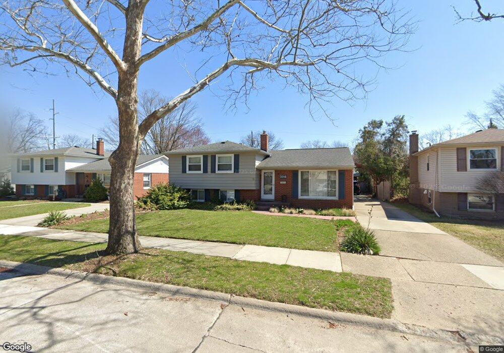
5086 Elmhurst Ave Royal Oak, MI 48073
Estimated Value: $397,445 - $481,000
4
Beds
2
Baths
1,745
Sq Ft
$247/Sq Ft
Est. Value
About This Home
This home is located at 5086 Elmhurst Ave, Royal Oak, MI 48073 and is currently estimated at $431,361, approximately $247 per square foot. 5086 Elmhurst Ave is a home located in Oakland County with nearby schools including Alfred E. Upton Elementary School, Royal Oak Middle School, and Royal Oak High School.
Ownership History
Date
Name
Owned For
Owner Type
Purchase Details
Closed on
Apr 4, 2020
Sold by
Steven Grant
Bought by
Steven And Kathie Grant Revocable Trust and Revoca Kathie
Current Estimated Value
Purchase Details
Closed on
Jun 11, 2007
Sold by
Grant Steve R and Grant Kathie A
Bought by
Grant Steven R and Grant Kathie A
Home Financials for this Owner
Home Financials are based on the most recent Mortgage that was taken out on this home.
Original Mortgage
$168,000
Interest Rate
6.2%
Mortgage Type
Purchase Money Mortgage
Create a Home Valuation Report for This Property
The Home Valuation Report is an in-depth analysis detailing your home's value as well as a comparison with similar homes in the area
Home Values in the Area
Average Home Value in this Area
Purchase History
| Date | Buyer | Sale Price | Title Company |
|---|---|---|---|
| Steven And Kathie Grant Revocable Trust | -- | None Listed On Document | |
| Grant Steven R | -- | Blue Water Title |
Source: Public Records
Mortgage History
| Date | Status | Borrower | Loan Amount |
|---|---|---|---|
| Previous Owner | Grant Steven R | $168,000 |
Source: Public Records
Tax History Compared to Growth
Tax History
| Year | Tax Paid | Tax Assessment Tax Assessment Total Assessment is a certain percentage of the fair market value that is determined by local assessors to be the total taxable value of land and additions on the property. | Land | Improvement |
|---|---|---|---|---|
| 2024 | $2,835 | $160,730 | $0 | $0 |
| 2022 | $3,350 | $145,210 | $0 | $0 |
| 2020 | $2,755 | $128,330 | $0 | $0 |
| 2018 | $3,350 | $100,830 | $0 | $0 |
| 2017 | $3,049 | $100,830 | $0 | $0 |
| 2015 | -- | $91,940 | $0 | $0 |
| 2014 | -- | $80,950 | $0 | $0 |
| 2011 | -- | $71,640 | $0 | $0 |
Source: Public Records
Map
Nearby Homes
- 2425 Torquay Ave Unit 101A
- 2134 Wickham St
- 1936 Torquay Ave Unit 205
- 1823 Torquay Ave
- 2420 Parmenter Blvd Unit 101
- 2440 Parmenter Blvd Unit 112
- 4859 Mansfield Ave Unit H5
- 4830 Briarwood Ave Unit 2
- 4820 Briarwood Ave Unit 4
- 4921 N Crooks Rd Unit N-10
- 4921 Crooks Rd Unit M-10
- 4840 Briarwood Ave Unit 8
- 4909 Crooks Rd Unit C7
- 4909 Crooks Rd Unit E8
- 4909 Crooks Rd Unit 4
- 496 Langley Blvd
- 2356 W 14 Mile Rd Unit 1
- 851 N Webik Ave
- 4625 Leafdale Ave
- 4422 Rosewold Ave
- 5090 Elmhurst Ave Unit Bldg-Unit
- 5090 Elmhurst Ave
- 5082 Elmhurst Ave
- 5094 Elmhurst Ave
- 5089 Thorncroft Ave
- 5083 Thorncroft Ave
- 5078 Elmhurst Ave
- 5093 Thorncroft Ave
- 5079 Thorncroft Ave
- 5087 Elmhurst Ave
- 5097 Thorncroft Ave
- 5091 Elmhurst Ave
- 5074 Elmhurst Ave
- 5083 Elmhurst Ave
- 5095 Elmhurst Ave
- 5069 Thorncroft Ave
- 5063 Thorncroft Ave
- 5070 Elmhurst Ave
- 2303 Torquay Ave
- 5104 Elmhurst Ave