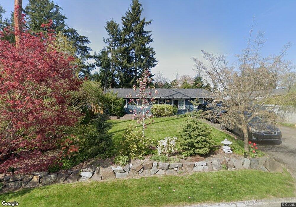
509 212th St SW Bothell, WA 98021
Queensborough-Brentwood NeighborhoodEstimated Value: $699,000 - $828,000
1
Bed
2
Baths
1,359
Sq Ft
$560/Sq Ft
Est. Value
About This Home
This home is located at 509 212th St SW, Bothell, WA 98021 and is currently estimated at $760,556, approximately $559 per square foot. 509 212th St SW is a home located in Snohomish County with nearby schools including Hilltop Elementary School, Brier Terrace Middle School, and Mountlake Terrace High School.
Ownership History
Date
Name
Owned For
Owner Type
Purchase Details
Closed on
Sep 13, 2005
Sold by
Kadinger David P and Kadinger Cindy L
Bought by
Sanders Brent and Sanders Christy
Current Estimated Value
Home Financials for this Owner
Home Financials are based on the most recent Mortgage that was taken out on this home.
Original Mortgage
$211,080
Outstanding Balance
$173,666
Interest Rate
7.7%
Mortgage Type
Fannie Mae Freddie Mac
Estimated Equity
$586,890
Purchase Details
Closed on
Apr 17, 2000
Sold by
Mcneal Travis J and Mcneal Laura K
Bought by
Kadinger David P and Kadinger Cindy L
Home Financials for this Owner
Home Financials are based on the most recent Mortgage that was taken out on this home.
Original Mortgage
$167,800
Interest Rate
8.24%
Purchase Details
Closed on
Oct 9, 1997
Sold by
Clasen Richard and Clasen Linda L
Bought by
Mcneal Travis J and Mcneal Laura K
Home Financials for this Owner
Home Financials are based on the most recent Mortgage that was taken out on this home.
Original Mortgage
$137,679
Interest Rate
7.54%
Mortgage Type
FHA
Create a Home Valuation Report for This Property
The Home Valuation Report is an in-depth analysis detailing your home's value as well as a comparison with similar homes in the area
Home Values in the Area
Average Home Value in this Area
Purchase History
| Date | Buyer | Sale Price | Title Company |
|---|---|---|---|
| Sanders Brent | $263,850 | Chicago Title | |
| Kadinger David P | $173,000 | Evergreen Title Company Inc | |
| Mcneal Travis J | $139,950 | -- |
Source: Public Records
Mortgage History
| Date | Status | Borrower | Loan Amount |
|---|---|---|---|
| Open | Sanders Brent | $211,080 | |
| Previous Owner | Kadinger David P | $167,800 | |
| Previous Owner | Mcneal Travis J | $137,679 |
Source: Public Records
Tax History
| Year | Tax Paid | Tax Assessment Tax Assessment Total Assessment is a certain percentage of the fair market value that is determined by local assessors to be the total taxable value of land and additions on the property. | Land | Improvement |
|---|---|---|---|---|
| 2025 | $5,371 | $665,500 | $450,800 | $214,700 |
| 2024 | $5,371 | $645,900 | $431,200 | $214,700 |
| 2023 | $5,734 | $722,100 | $508,600 | $213,500 |
| 2022 | $5,239 | $536,700 | $355,700 | $181,000 |
| 2020 | $4,635 | $423,000 | $306,500 | $116,500 |
| 2019 | $4,096 | $366,400 | $257,100 | $109,300 |
| 2018 | $4,128 | $325,500 | $228,000 | $97,500 |
| 2017 | $3,330 | $270,600 | $179,500 | $91,100 |
| 2016 | $3,043 | $247,600 | $160,100 | $87,500 |
Source: Public Records
Map
Nearby Homes
- 604 213th St SW
- 410 214th St SW Unit B
- 625 215th St SW
- 215 Hubbard Rd
- 610 Logan Rd
- 422 216th St SW
- 20912 2nd Ave W
- 20902 2nd Ave W
- 21120 Meridian Place W
- 33 213th Place SW
- 20507 9th Ave W
- 20911 W Richmond Rd
- 21414 2nd Ave SE
- 110 204th Place SW
- 20914 13th Place W
- 1132 Crawford Rd
- 531 221st St SW
- 130 203rd Place SW
- 20231 4th Place W
- 20823 14th Place W
- 517 212th St SW
- 21124 5th Ave W
- 21116 5th Ave W
- 518 Hubbard Rd
- 523 212th St SW
- 520 Hubbard Rd
- 516 212th St SW
- 21110 5th Ave W
- 524 212th St SW
- 508 212th St SW
- 527 212th St SW
- 21133 5th Dr SE
- 526 212th St SW
- 500 212th St SW
- 531 212th St SW
- 417 212th St SW
- 21113 5th Ave W
- 532 213th St SW
- 426 212th St SW
Your Personal Tour Guide
Ask me questions while you tour the home.