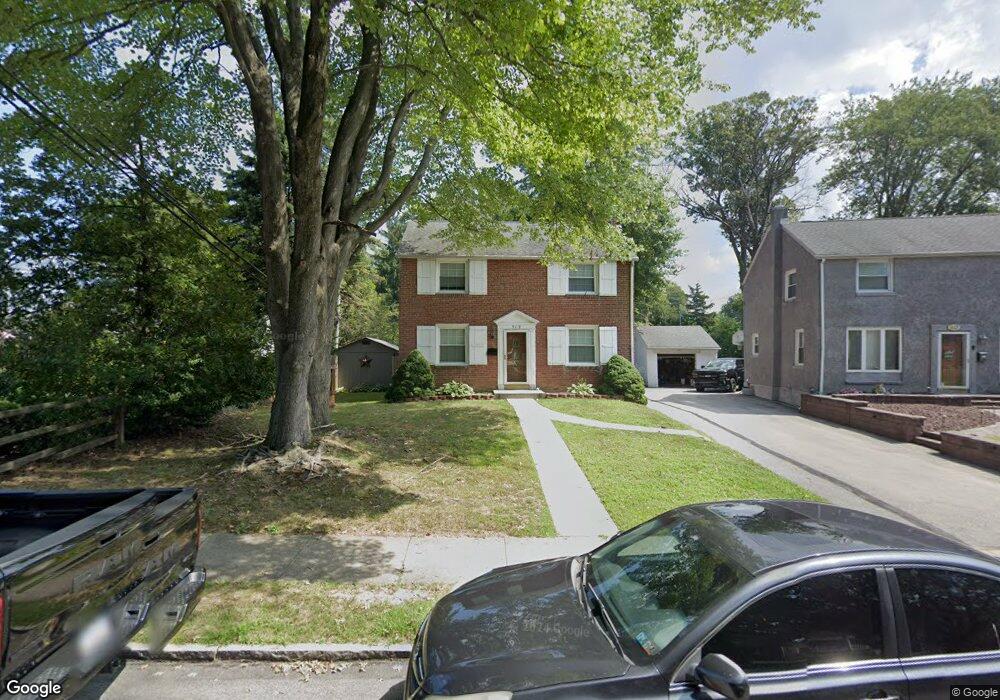
509 Evans Rd Springfield, PA 19064
Estimated Value: $504,068 - $548,000
3
Beds
2
Baths
1,770
Sq Ft
$292/Sq Ft
Est. Value
About This Home
This home is located at 509 Evans Rd, Springfield, PA 19064 and is currently estimated at $517,017, approximately $292 per square foot. 509 Evans Rd is a home located in Delaware County with nearby schools including Springfield High School, St Francis Of Assisi School, and Holy Cross School.
Ownership History
Date
Name
Owned For
Owner Type
Purchase Details
Closed on
Jun 23, 2021
Sold by
Heppard James C and Heppard Phyllis T
Bought by
Trapp Montess and Mcdyre Jennifer
Current Estimated Value
Home Financials for this Owner
Home Financials are based on the most recent Mortgage that was taken out on this home.
Original Mortgage
$398,970
Outstanding Balance
$361,218
Interest Rate
2.9%
Mortgage Type
VA
Estimated Equity
$155,799
Purchase Details
Closed on
Dec 29, 2006
Sold by
Macgregor Martha L
Bought by
Heppard James C and Heppard Phyllis T
Home Financials for this Owner
Home Financials are based on the most recent Mortgage that was taken out on this home.
Original Mortgage
$65,000
Interest Rate
6.18%
Mortgage Type
Purchase Money Mortgage
Create a Home Valuation Report for This Property
The Home Valuation Report is an in-depth analysis detailing your home's value as well as a comparison with similar homes in the area
Home Values in the Area
Average Home Value in this Area
Purchase History
| Date | Buyer | Sale Price | Title Company |
|---|---|---|---|
| Trapp Montess | $390,000 | Pando Abstract Llc | |
| Heppard James C | $225,000 | None Available |
Source: Public Records
Mortgage History
| Date | Status | Borrower | Loan Amount |
|---|---|---|---|
| Open | Trapp Montess | $398,970 | |
| Previous Owner | Heppard James C | $65,000 |
Source: Public Records
Tax History
| Year | Tax Paid | Tax Assessment Tax Assessment Total Assessment is a certain percentage of the fair market value that is determined by local assessors to be the total taxable value of land and additions on the property. | Land | Improvement |
|---|---|---|---|---|
| 2025 | $8,423 | $299,680 | $130,830 | $168,850 |
| 2024 | $8,423 | $299,680 | $130,830 | $168,850 |
| 2023 | $8,111 | $299,680 | $130,830 | $168,850 |
| 2022 | $7,935 | $299,680 | $130,830 | $168,850 |
| 2021 | $12,289 | $299,680 | $130,830 | $168,850 |
| 2020 | $7,219 | $159,310 | $62,900 | $96,410 |
| 2019 | $7,050 | $159,310 | $62,900 | $96,410 |
| 2018 | $6,949 | $159,310 | $0 | $0 |
| 2017 | $6,788 | $159,310 | $0 | $0 |
| 2016 | $874 | $159,310 | $0 | $0 |
| 2015 | $892 | $159,310 | $0 | $0 |
| 2014 | $874 | $159,310 | $0 | $0 |
Source: Public Records
Map
Nearby Homes
- 334 Parham Rd
- 253 Saxer Ave
- 720 Evans Rd
- 226 Lynbrooke Rd
- 658 E Leamy Ave
- 225 Lynbrooke Rd
- 238 Alliston Rd
- 227 E Leamy Ave
- 838 West Ave
- 264 Pancoast Ave
- 114 Providence Rd
- 354 E Springfield Rd
- 231 E Woodland Ave
- 514 Springview Ln
- 933 Greenbriar Ln
- 1022 Crozer Ln
- 364 S Rolling Rd
- 29 School Ln
- 507 School St
- 1005 Edwards Dr
Your Personal Tour Guide
Ask me questions while you tour the home.