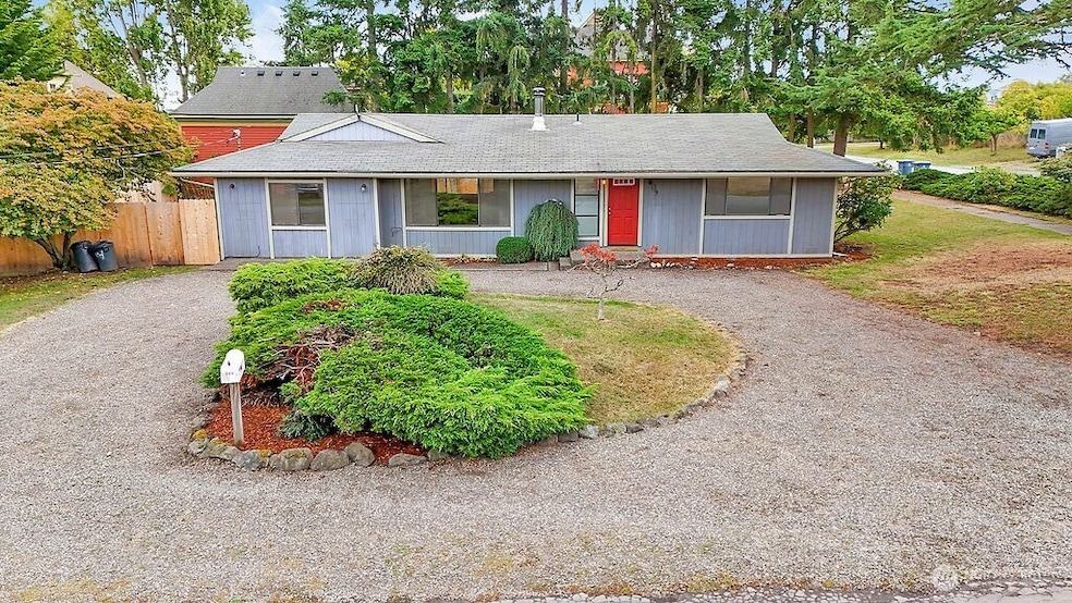
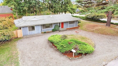
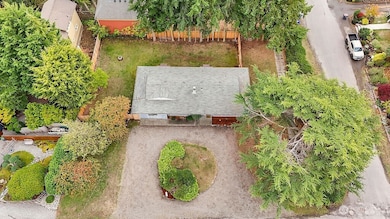
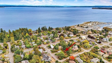
509 Garfield St Port Townsend, WA 98368
Estimated payment $3,753/month
Highlights
- Wood Burning Stove
- Traditional Architecture
- No HOA
- Property is near public transit
- Corner Lot
- 3-minute walk to Chetzemoka Park
About This Home
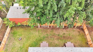
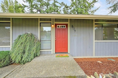
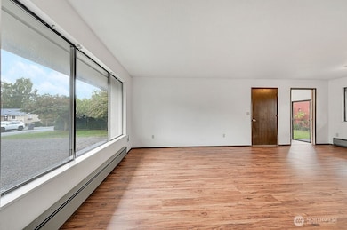
Location, location, location! Oversized, sunny corner lot, a block from Chetzemoka Park, the beach and close to the action in Uptown and downtown businesses. Easy living in this single level home with 3 bedrooms, 1/1/2 bath and large living/dining room area. Wood stove in living room. The house is in good condition and very livable while needing updating. A blank slate ready for your creativity. Light filled home with light from both the south and the north. Fully fenced backyard. Great value in the Uptown area.
Source: Northwest Multiple Listing Service (NWMLS)
MLS#: 2420603
Property Details
Home Type
- Co-Op
Est. Annual Taxes
- $4,920
Year Built
- Built in 1980
Lot Details
- 8,276 Sq Ft Lot
- North Facing Home
- Partially Fenced Property
- Brush Vegetation
- Corner Lot
- Level Lot
Home Design
- Traditional Architecture
- Poured Concrete
- Composition Roof
- Wood Siding
Interior Spaces
- 1,400 Sq Ft Home
- 1-Story Property
- Wood Burning Stove
Kitchen
- Stove
- Dishwasher
Flooring
- Carpet
- Laminate
- Vinyl
Bedrooms and Bathrooms
- 3 Main Level Bedrooms
- Bathroom on Main Level
Laundry
- Dryer
- Washer
Parking
- Driveway
- Off-Street Parking
Location
- Property is near public transit
- Property is near a bus stop
Schools
- Salish Coast Elementary School
- Blue Heron Mid Middle School
- Port Townsend High School
Utilities
- Baseboard Heating
Community Details
- No Home Owners Association
- Plummer's Addition Condos
- Uptown Subdivision
Listing and Financial Details
- Down Payment Assistance Available
- Visit Down Payment Resource Website
- Legal Lot and Block 5 (N1/2), 7 (ALL) / 8
- Assessor Parcel Number 988800803
Map
Home Values in the Area
Average Home Value in this Area
Tax History
| Year | Tax Paid | Tax Assessment Tax Assessment Total Assessment is a certain percentage of the fair market value that is determined by local assessors to be the total taxable value of land and additions on the property. | Land | Improvement |
|---|---|---|---|---|
| 2024 | $4,788 | $563,998 | $294,000 | $269,998 |
| 2023 | $4,788 | $533,259 | $275,000 | $258,259 |
| 2022 | $4,380 | $528,259 | $270,000 | $258,259 |
| 2021 | $4,013 | $451,436 | $235,500 | $215,936 |
| 2020 | $3,935 | $398,863 | $206,063 | $192,800 |
| 2019 | $3,534 | $381,338 | $196,250 | $185,088 |
| 2018 | $3,898 | $371,981 | $196,250 | $175,731 |
| 2017 | $3,594 | $358,639 | $208,000 | $150,639 |
| 2016 | $3,141 | $353,259 | $208,000 | $145,259 |
| 2015 | $3,034 | $321,119 | $192,000 | $129,119 |
| 2014 | -- | $307,739 | $184,000 | $123,739 |
| 2013 | -- | $267,600 | $160,000 | $107,600 |
Property History
| Date | Event | Price | List to Sale | Price per Sq Ft |
|---|---|---|---|---|
| 10/31/2025 10/31/25 | Price Changed | $635,000 | -2.3% | $454 / Sq Ft |
| 10/03/2025 10/03/25 | For Sale | $650,000 | -- | $464 / Sq Ft |
Purchase History
| Date | Type | Sale Price | Title Company |
|---|---|---|---|
| Interfamily Deed Transfer | -- | None Available | |
| Warranty Deed | $335,000 | Jefferson Title Co |
Mortgage History
| Date | Status | Loan Amount | Loan Type |
|---|---|---|---|
| Closed | $10,000 | New Conventional |
Source: Northwest Multiple Listing Service (NWMLS)
MLS Number: 2420603
APN: 988800803
Disclaimer: Certain information contained herein is derived from information provided by parties other than Homes.com. All information provided is deemed reliable, but is not guaranteed to be accurate and should be independently verified.
![]() All data is obtained from various sources and may not have been verified by broker or MLS GRID. Supplied Open House Information is subject to change without notice. All information should be independently reviewed and verified for accuracy. Properties may or may not be listed by the office/agent presenting the information. Listing information is provided by the Northwest Multiple Listing Service (NWMLS). Property information is based on available data that may include MLS information, county records, and other sources. Listings marked with the 3 tree icon and provided by NWMLS. All properties are subject to prior sale or withdrawal. IDX information is provided exclusively for consumers’ personal noncommercial use, that it may not be used for any purpose other than to identify prospective properties consumers may be interested in purchasing, that the data is deemed reliable but is not guaranteed by MLS GRID. ©2025 NWMLS.
All data is obtained from various sources and may not have been verified by broker or MLS GRID. Supplied Open House Information is subject to change without notice. All information should be independently reviewed and verified for accuracy. Properties may or may not be listed by the office/agent presenting the information. Listing information is provided by the Northwest Multiple Listing Service (NWMLS). Property information is based on available data that may include MLS information, county records, and other sources. Listings marked with the 3 tree icon and provided by NWMLS. All properties are subject to prior sale or withdrawal. IDX information is provided exclusively for consumers’ personal noncommercial use, that it may not be used for any purpose other than to identify prospective properties consumers may be interested in purchasing, that the data is deemed reliable but is not guaranteed by MLS GRID. ©2025 NWMLS.
Based on information submitted to the MLS GRID
- 1055 Monroe St
- 537 Jackson St
- 538 Adams St
- 717 Franklin St
- 800 Polk St Unit 204C
- 842 Washington St Unit 204
- 301 E St
- 308 E St
- 1707 Jackson St
- 999 Reed St
- 9999 Maple Parcel A & B St
- 9999 Maple Parcel A St
- 7 XXX Water St
- 1602 Lincoln St
- 0 XXX P St
- 1815 Lawrence St
- 1738 Washington St
- 1839 Redwood St
- 1930 Lawrence St Unit A31
- 1431 Beech St
- 2500 9th St
- 191 Airport Rd
- 51 Colwell St
- 31 Colwell St
- 10894 Rhody Dr
- 9 NW Front St
- 5 Front St NW
- 250 North St Unit A
- 250 North St
- 180 Parker Rd
- 392 Buck Loop Rd
- 275 SE Pioneer Way Unit 100
- 275 SE Pioneer Way Unit 204
- 270 SE Pioneer Way
- 380 SE Barrington Dr
- 1121 SE Dock St
- 300 E Whidbey Ave
- 520 E Whidbey Ave Unit 205
- 152 NE Midway Blvd
- 2279 Elger Park Rd
