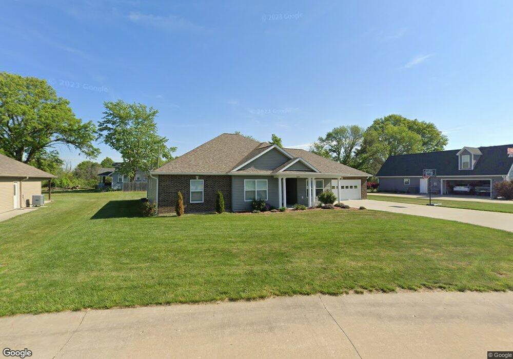
509 Kentucky St Moberly, MO 65270
Estimated Value: $275,000 - $357,000
3
Beds
2
Baths
2,000
Sq Ft
$162/Sq Ft
Est. Value
About This Home
This home is located at 509 Kentucky St, Moberly, MO 65270 and is currently estimated at $324,836, approximately $162 per square foot. 509 Kentucky St is a home located in Randolph County with nearby schools including Moberly Senior High School, Maranatha Seventh-day Adventist School, and Terrill Road Christian Academy.
Ownership History
Date
Name
Owned For
Owner Type
Purchase Details
Closed on
Jun 19, 2020
Sold by
Deborah Kay Barrett Ret
Bought by
Chang Sara M
Current Estimated Value
Purchase Details
Closed on
Aug 3, 2015
Sold by
Barrett Deborah K
Bought by
Barrett Deborah K
Purchase Details
Closed on
Jul 17, 2015
Sold by
Barrett Deborah K
Bought by
Barrett Deborah K
Purchase Details
Closed on
Jun 22, 2015
Sold by
Jackie White Construction Llc
Bought by
Barrett Deborah K
Purchase Details
Closed on
Mar 8, 2012
Sold by
White Jackie L and White Iris L
Bought by
Deck Ronald M and Deck Joyce L
Create a Home Valuation Report for This Property
The Home Valuation Report is an in-depth analysis detailing your home's value as well as a comparison with similar homes in the area
Home Values in the Area
Average Home Value in this Area
Purchase History
| Date | Buyer | Sale Price | Title Company |
|---|---|---|---|
| Chang Sara M | -- | None Available | |
| Barrett Deborah K | -- | None Available | |
| Barrett Deborah K | -- | None Available | |
| Barrett Deborah K | -- | None Available | |
| Deck Ronald M | -- | -- |
Source: Public Records
Tax History Compared to Growth
Tax History
| Year | Tax Paid | Tax Assessment Tax Assessment Total Assessment is a certain percentage of the fair market value that is determined by local assessors to be the total taxable value of land and additions on the property. | Land | Improvement |
|---|---|---|---|---|
| 2025 | $3,328 | $49,370 | $3,490 | $45,880 |
| 2024 | $3,328 | $45,700 | $3,040 | $42,660 |
| 2023 | $3,379 | $45,700 | $3,040 | $42,660 |
| 2022 | $3,164 | $43,940 | $3,040 | $40,900 |
| 2021 | $3,162 | $43,940 | $3,040 | $40,900 |
| 2020 | $3,162 | $43,940 | $3,040 | $40,900 |
| 2019 | $3,155 | $43,940 | $3,040 | $40,900 |
| 2018 | $3,150 | $44,010 | $3,040 | $40,970 |
| 2017 | $3,144 | $44,010 | $0 | $0 |
| 2016 | $2,943 | $41,430 | $0 | $0 |
| 2014 | -- | $4,560 | $0 | $0 |
| 2013 | -- | $4,560 | $0 | $0 |
| 2012 | -- | $4,560 | $0 | $0 |
Source: Public Records
Map
Nearby Homes
- 315 W Urbandale Dr
- 1825 S Morley St
- 1826 S Morley St
- 501 Terrill Rd
- 1365 Lantern Pointe Dr
- 1471 Trails End
- 1377 Conestoga Trace
- 713 Homestead Dr
- 2010 Sterling Dr
- 1216 Shepherds Dr
- 1227 Conestoga Trace
- 0 S Ridge Subdivision Unit 413910
- 0 S Ridge Subdivision Unit 413909
- 0 S Ridge Subdivision Unit 413908
- 0 S Ridge Subdivision Unit 413906
- 0 S Ridge Subdivision Unit 18-418
- 0 S Ridge Subdivision Unit 18-417
- 0 S Ridge Subdivision Unit 18-416
- 0 S Ridge Subdivision Unit 22-6
- 900 Destinee Dr
- 1817 Chariton Ave
- 511 Kentucky St
- 1826 6 Mile Ln
- 1901 Chariton Ave
- 1815 Chariton Ave
- 1902 Chariton Ave
- 1820 6 Mile Ln
- 1813 Wabash Ave
- 1903 Chariton Ave
- 1901 Wabash Ave
- 1811 Wabash Ave
- 1903 Wabash Ave
- 1904 Chariton Ave
- 1905 Chariton Ave
- 1809 Wabash Ave
- 1905 Wabash Ave
- 1814 Wabash Ave
- 1900 Wabash Ave
- 1906 Chariton Ave
- 1907 Chariton Ave