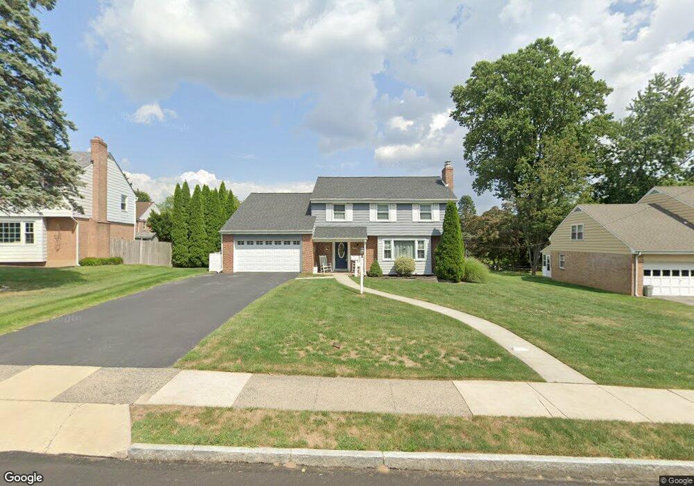
509 Kerr Ln Springfield, PA 19064
Estimated Value: $587,000 - $643,000
4
Beds
3
Baths
2,324
Sq Ft
$264/Sq Ft
Est. Value
About This Home
This home is located at 509 Kerr Ln, Springfield, PA 19064 and is currently estimated at $614,027, approximately $264 per square foot. 509 Kerr Ln is a home located in Delaware County with nearby schools including Springfield High School, St Francis Of Assisi School, and Holy Cross School.
Ownership History
Date
Name
Owned For
Owner Type
Purchase Details
Closed on
Mar 9, 2007
Sold by
Coll John V
Bought by
Mcknight Francis X and Mcknight Maureen C
Current Estimated Value
Home Financials for this Owner
Home Financials are based on the most recent Mortgage that was taken out on this home.
Original Mortgage
$55,725
Outstanding Balance
$44,924
Interest Rate
6.33%
Mortgage Type
Credit Line Revolving
Estimated Equity
$569,103
Purchase Details
Closed on
Feb 26, 2004
Sold by
Kerr Paula Curtis
Bought by
Coll John
Home Financials for this Owner
Home Financials are based on the most recent Mortgage that was taken out on this home.
Original Mortgage
$256,000
Interest Rate
3%
Mortgage Type
Purchase Money Mortgage
Purchase Details
Closed on
Jun 28, 2000
Sold by
Sexton David N
Bought by
Kerr Paula Curtis
Create a Home Valuation Report for This Property
The Home Valuation Report is an in-depth analysis detailing your home's value as well as a comparison with similar homes in the area
Home Values in the Area
Average Home Value in this Area
Purchase History
| Date | Buyer | Sale Price | Title Company |
|---|---|---|---|
| Mcknight Francis X | $371,500 | None Available | |
| Coll John | $320,000 | Commonwealth Title | |
| Kerr Paula Curtis | -- | -- |
Source: Public Records
Mortgage History
| Date | Status | Borrower | Loan Amount |
|---|---|---|---|
| Open | Mcknight Francis X | $55,725 | |
| Open | Mcknight Francis X | $297,200 | |
| Previous Owner | Coll John | $256,000 |
Source: Public Records
Tax History Compared to Growth
Tax History
| Year | Tax Paid | Tax Assessment Tax Assessment Total Assessment is a certain percentage of the fair market value that is determined by local assessors to be the total taxable value of land and additions on the property. | Land | Improvement |
|---|---|---|---|---|
| 2025 | $8,726 | $310,460 | $98,630 | $211,830 |
| 2024 | $8,726 | $310,460 | $98,630 | $211,830 |
| 2023 | $8,402 | $310,460 | $98,630 | $211,830 |
| 2022 | $8,221 | $310,460 | $98,630 | $211,830 |
| 2021 | $12,731 | $310,460 | $98,630 | $211,830 |
| 2020 | $8,161 | $180,110 | $47,420 | $132,690 |
| 2019 | $7,970 | $180,110 | $47,420 | $132,690 |
| 2018 | $7,856 | $180,110 | $0 | $0 |
| 2017 | $7,674 | $180,110 | $0 | $0 |
| 2016 | $988 | $180,110 | $0 | $0 |
| 2015 | $1,009 | $180,110 | $0 | $0 |
| 2014 | $988 | $180,110 | $0 | $0 |
Source: Public Records
Map
Nearby Homes
- 517 W Woodland Ave
- 341 Kennerly Rd
- 232 S Highland Rd
- 457 Kennerly Rd
- 201 S Highland Rd
- 247 Orchard Rd
- 15 Pearson Dr
- 200 N State Rd
- 89 Saxer Ave
- 364 S Rolling Rd
- 506 Flora Cir
- 499 Collins Dr
- 464 Conard Dr
- 165 Summit Rd
- 326 Powell Rd
- 251 Powell Rd
- 214 Lynbrooke Rd
- 225 Lynbrooke Rd
- 140 N Rolling Rd
- 30 Wayne Ave