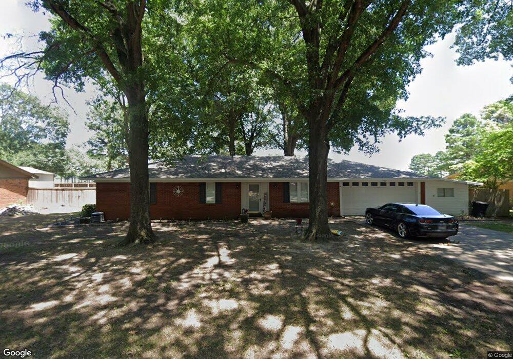
509 Wade St Mc Crory, AR 72101
Estimated Value: $119,000 - $192,000
3
Beds
2
Baths
2,015
Sq Ft
$79/Sq Ft
Est. Value
About This Home
This home is located at 509 Wade St, Mc Crory, AR 72101 and is currently estimated at $159,154, approximately $78 per square foot. 509 Wade St is a home located in Woodruff County with nearby schools including McCrory Elementary School and McCrory High School.
Ownership History
Date
Name
Owned For
Owner Type
Purchase Details
Closed on
Dec 29, 2021
Sold by
Garner Thomas N
Bought by
Powell John Luke
Current Estimated Value
Home Financials for this Owner
Home Financials are based on the most recent Mortgage that was taken out on this home.
Original Mortgage
$142,373
Outstanding Balance
$131,214
Interest Rate
3.11%
Mortgage Type
New Conventional
Estimated Equity
$27,940
Purchase Details
Closed on
Dec 3, 2012
Sold by
Marsh Gloria K
Bought by
Garner Thomas N
Home Financials for this Owner
Home Financials are based on the most recent Mortgage that was taken out on this home.
Original Mortgage
$107,142
Interest Rate
3.41%
Purchase Details
Closed on
Oct 21, 2011
Sold by
Marsh Randall and Marsh Janice
Bought by
Gloria K Marsh Living Trust And Randall
Purchase Details
Closed on
Jun 10, 2003
Bought by
Marsh Dorothy K and Marsh Randall
Purchase Details
Closed on
Oct 2, 1996
Bought by
Hale Dorothy Banks
Create a Home Valuation Report for This Property
The Home Valuation Report is an in-depth analysis detailing your home's value as well as a comparison with similar homes in the area
Home Values in the Area
Average Home Value in this Area
Purchase History
| Date | Buyer | Sale Price | Title Company |
|---|---|---|---|
| Powell John Luke | $145,000 | Dalco Closing & Title | |
| Garner Thomas N | -- | -- | |
| Gloria K Marsh Living Trust And Randall | -- | -- | |
| Marsh Dorothy K | $95,000 | -- | |
| Hale Dorothy Banks | $59,000 | -- |
Source: Public Records
Mortgage History
| Date | Status | Borrower | Loan Amount |
|---|---|---|---|
| Open | Powell John Luke | $142,373 | |
| Previous Owner | Garner Thomas N | $107,142 |
Source: Public Records
Tax History Compared to Growth
Tax History
| Year | Tax Paid | Tax Assessment Tax Assessment Total Assessment is a certain percentage of the fair market value that is determined by local assessors to be the total taxable value of land and additions on the property. | Land | Improvement |
|---|---|---|---|---|
| 2024 | $761 | $24,670 | $2,130 | $22,540 |
| 2023 | $811 | $24,670 | $2,130 | $22,540 |
| 2022 | $861 | $24,670 | $2,130 | $22,540 |
| 2021 | $861 | $24,670 | $2,130 | $22,540 |
| 2020 | $810 | $24,670 | $2,130 | $22,540 |
| 2019 | $754 | $22,530 | $1,640 | $20,890 |
| 2018 | $779 | $22,530 | $1,640 | $20,890 |
| 2017 | $758 | $22,530 | $1,640 | $20,890 |
| 2016 | $716 | $21,660 | $1,640 | $20,020 |
| 2015 | $716 | $20,675 | $1,640 | $19,035 |
| 2014 | $619 | $19,690 | $3,250 | $16,440 |
Source: Public Records
Map
Nearby Homes
- 603 Seaman
- 505 E 3rd St
- 0 Edmonds Ave Unit 25036424
- 209 Cain Dr
- 103 Raney Ave
- 211 Raymond Circle Dr
- 307 W 2nd St
- 103 Maple St
- 307 W Chestnut St
- 0 Woodruff 793 Unit 25024183
- 000 Woodruff Cr 361
- 8114 Arkansas 145
- 00 Duncan Bend Trail
- 000 Hwy 64
- 20 Cr 505
- 20 C R 505
- 301 Pine St
- 301 Pine St
- 617 Walnut St
- 601 Broadway St