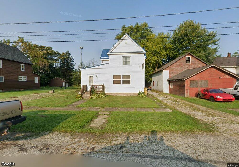
509 Wrights Ave Conneaut, OH 44030
Estimated Value: $72,860 - $114,000
3
Beds
1
Bath
1,484
Sq Ft
$61/Sq Ft
Est. Value
About This Home
This home is located at 509 Wrights Ave, Conneaut, OH 44030 and is currently estimated at $90,965, approximately $61 per square foot. 509 Wrights Ave is a home located in Ashtabula County with nearby schools including Lakeshore Primary Elementary School, Gateway Elementary School, and Conneaut Middle School.
Ownership History
Date
Name
Owned For
Owner Type
Purchase Details
Closed on
May 10, 2023
Sold by
Mcdonald Roger A
Bought by
Newhart David
Current Estimated Value
Purchase Details
Closed on
Jul 12, 2021
Sold by
Mcdonald Roger A
Bought by
Mcdonald Roger A and Mcdonald Kenneth R
Purchase Details
Closed on
Jun 1, 2011
Sold by
Malbasa Stephanie H
Bought by
Mcdonald Rebecca A and Mcdonald Roger A
Purchase Details
Closed on
Apr 28, 2008
Sold by
Carducci Lucy C
Bought by
Carducci Lucy C
Purchase Details
Closed on
Jul 15, 2003
Sold by
Carducci Michael J and Carducci Lisa M
Bought by
Carducci Lucy C
Purchase Details
Closed on
Jul 9, 2003
Sold by
Estate Of James L Carducci
Bought by
Carducci Lisa M and Carducci Timothy J
Create a Home Valuation Report for This Property
The Home Valuation Report is an in-depth analysis detailing your home's value as well as a comparison with similar homes in the area
Home Values in the Area
Average Home Value in this Area
Purchase History
| Date | Buyer | Sale Price | Title Company |
|---|---|---|---|
| Newhart David | $32,000 | Title Professionals Group | |
| Mcdonald Roger A | -- | None Available | |
| Mcdonald Rebecca A | $25,000 | Chicago Title | |
| Carducci Lucy C | -- | Attorney | |
| Carducci Lucy C | -- | -- | |
| Carducci Lisa M | -- | -- |
Source: Public Records
Tax History
| Year | Tax Paid | Tax Assessment Tax Assessment Total Assessment is a certain percentage of the fair market value that is determined by local assessors to be the total taxable value of land and additions on the property. | Land | Improvement |
|---|---|---|---|---|
| 2024 | $1,614 | $22,060 | $3,750 | $18,310 |
| 2023 | $1,029 | $22,060 | $3,750 | $18,310 |
| 2022 | $900 | $16,980 | $2,870 | $14,110 |
| 2021 | $916 | $16,980 | $2,870 | $14,110 |
| 2020 | $915 | $16,980 | $2,870 | $14,110 |
| 2019 | $249 | $13,160 | $1,610 | $11,550 |
| 2018 | $238 | $13,160 | $1,610 | $11,550 |
| 2017 | $237 | $13,160 | $1,610 | $11,550 |
| 2016 | $318 | $15,340 | $1,860 | $13,480 |
| 2015 | $321 | $15,340 | $1,860 | $13,480 |
| 2014 | $283 | $15,340 | $1,860 | $13,480 |
| 2013 | $272 | $15,260 | $2,100 | $13,160 |
Source: Public Records
Map
Nearby Homes
Your Personal Tour Guide
Ask me questions while you tour the home.