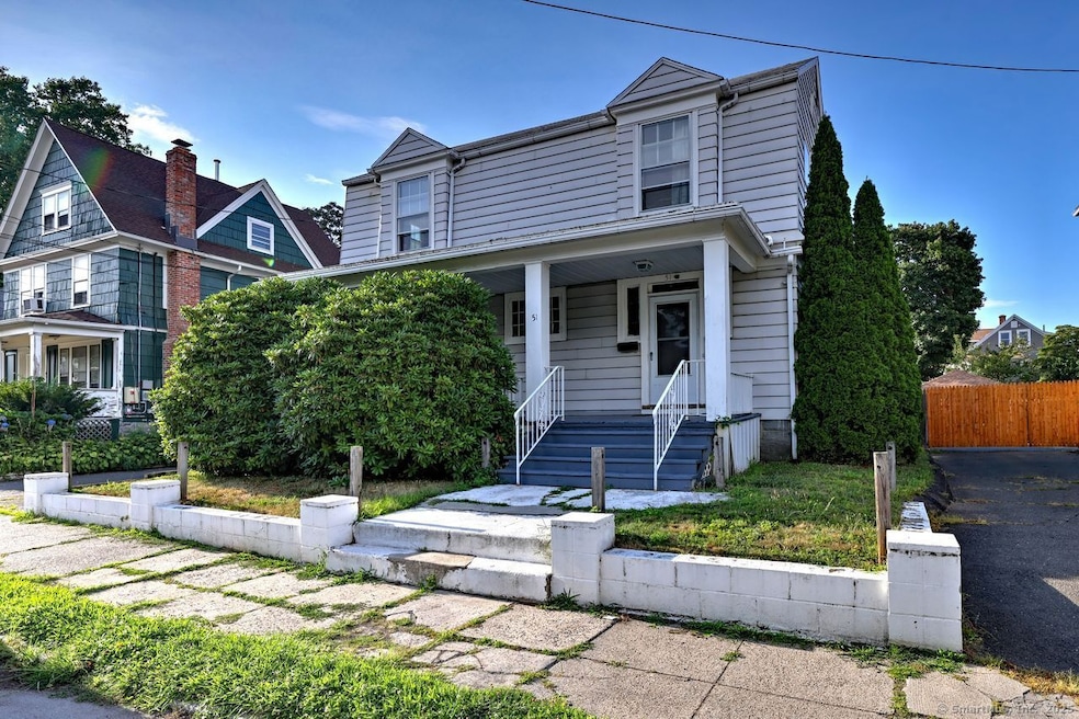
51 Alpine St Bridgeport, CT 06610
North Bridgeport NeighborhoodEstimated payment $2,616/month
Highlights
- Colonial Architecture
- 1 Fireplace
- Level Lot
- Attic
- 60+ Gallon Tank
About This Home
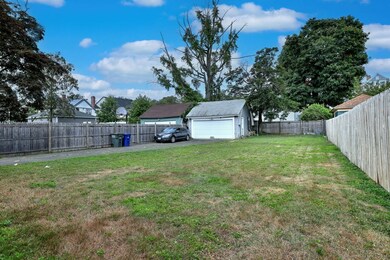
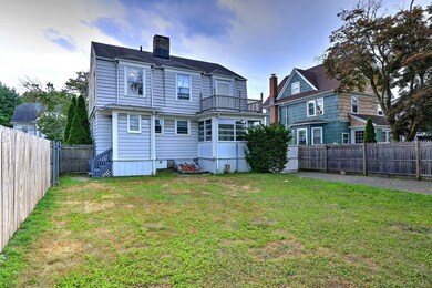
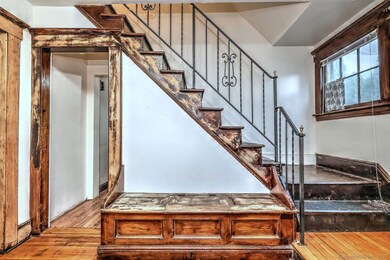
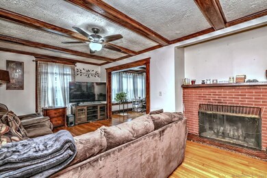
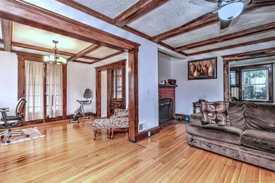
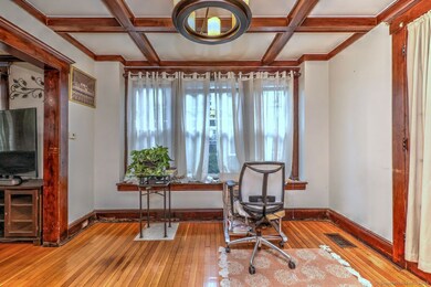
Welcome to this delightful 4-bedroom, 1.5-bathroom colonial residence, a distinctive offering near Beardsley Park. With its inviting presence and meticulously maintained exterior, this home captures the essence of traditional comfort intertwined with potential for modern upgrades. As you arrive, you're greeted by a welcoming front porch-a perfect spot for morning coffee or afternoon relaxation. The sprawling 2,220 square feet of living space opens up to a warm and inviting living room, enhanced by exposed wooden beams and a brick fireplace. The kitchen, equipped with charming wooden cabinetry and modern appliances. Adjoining is a dining area that overlooks the backyard, ideal for casual dining and entertaining. Each of the four bedrooms provides a comfortable space, with ample room for personalization. The attic, an untapped opportunity with abundant natural light, awaits your creative touch. Step outside to discover a generously-sized backyard, fenced for privacy and safety, making it an ideal playground or spot for outdoor entertainment. Bran new roof just installed!!!!
Home Details
Home Type
- Single Family
Est. Annual Taxes
- $7,088
Year Built
- Built in 1910
Lot Details
- 7,405 Sq Ft Lot
- Level Lot
- Property is zoned RB
Parking
- 2 Car Garage
Home Design
- Colonial Architecture
- Concrete Foundation
- Asphalt Shingled Roof
- Aluminum Siding
- Concrete Siding
Interior Spaces
- 2,220 Sq Ft Home
- 1 Fireplace
- Basement Fills Entire Space Under The House
- Walkup Attic
Kitchen
- Oven or Range
- Dishwasher
Bedrooms and Bathrooms
- 4 Bedrooms
Laundry
- Electric Dryer
- Washer
Utilities
- Window Unit Cooling System
- Heating System Uses Gas
- Gas Available at Street
- 60+ Gallon Tank
Listing and Financial Details
- Assessor Parcel Number 28634
Map
Home Values in the Area
Average Home Value in this Area
Tax History
| Year | Tax Paid | Tax Assessment Tax Assessment Total Assessment is a certain percentage of the fair market value that is determined by local assessors to be the total taxable value of land and additions on the property. | Land | Improvement |
|---|---|---|---|---|
| 2025 | $7,088 | $163,120 | $52,580 | $110,540 |
| 2024 | $7,088 | $163,120 | $52,580 | $110,540 |
| 2023 | $7,088 | $163,120 | $52,580 | $110,540 |
| 2022 | $7,088 | $163,120 | $52,580 | $110,540 |
| 2021 | $7,088 | $163,120 | $52,580 | $110,540 |
| 2020 | $8,022 | $148,590 | $50,790 | $97,800 |
| 2019 | $8,022 | $148,590 | $50,790 | $97,800 |
| 2018 | $8,079 | $148,590 | $50,790 | $97,800 |
| 2017 | $8,079 | $148,590 | $50,790 | $97,800 |
| 2016 | $8,079 | $148,590 | $50,790 | $97,800 |
| 2015 | $7,413 | $175,660 | $55,590 | $120,070 |
| 2014 | $7,413 | $175,660 | $55,590 | $120,070 |
Property History
| Date | Event | Price | List to Sale | Price per Sq Ft |
|---|---|---|---|---|
| 09/18/2025 09/18/25 | For Sale | $385,000 | 0.0% | $173 / Sq Ft |
| 08/21/2025 08/21/25 | Off Market | $385,000 | -- | -- |
| 08/07/2025 08/07/25 | Pending | -- | -- | -- |
| 07/22/2025 07/22/25 | For Sale | $385,000 | -- | $173 / Sq Ft |
Purchase History
| Date | Type | Sale Price | Title Company |
|---|---|---|---|
| Quit Claim Deed | -- | -- | |
| Quit Claim Deed | -- | -- | |
| Warranty Deed | $85,000 | -- | |
| Warranty Deed | $85,000 | -- |
Mortgage History
| Date | Status | Loan Amount | Loan Type |
|---|---|---|---|
| Previous Owner | $85,000 | No Value Available | |
| Previous Owner | $80,700 | Unknown | |
| Previous Owner | $68,000 | No Value Available |
Source: SmartMLS
MLS Number: 24113650
APN: BRID-002009-000007
Disclaimer: Certain information contained herein is derived from information provided by parties other than Homes.com. All information provided is deemed reliable, but is not guaranteed to be accurate and should be independently verified.
![]() IDX information is provided exclusively for personal, non-commercial use, and may not be used for any purpose other than to identify prospective properties consumers may be interested in purchasing. Information is deemed reliable but not guaranteed.
IDX information is provided exclusively for personal, non-commercial use, and may not be used for any purpose other than to identify prospective properties consumers may be interested in purchasing. Information is deemed reliable but not guaranteed.
- 149 Edna Ave Unit 153
- 170 Livingston Place Unit 172
- 230 Hickory St
- 154 Rose St
- 112 Glenwood Ave
- 2031 E Main St
- 83 Berkeley Place Unit 85
- 142 Palm St
- 33 Louisiana Ave Unit 35
- 44 Locust St Unit 46
- 132 Virginia Ave Unit 132
- 199 Bradley St Unit 203
- 120 Huntington Turnpike Unit 606
- 120 Huntington Turnpike Unit 801
- 11 Nob Hill Cir
- 1296 Noble Ave
- 202 Goddard Ave
- 769 Sylvan Ave Unit 16
- 769 Sylvan Ave Unit 13
- 15 Edwards St
- 105 Beardsley Park Terrace Unit 107
- 65 Palm St Unit 2
- 330 Bradley St
- 158 Louisiana Ave
- 527 Huntington Rd Unit 3
- 230 Texas Ave Unit 230
- 120 Huntington Turnpike Unit 1
- 1315 Noble Ave Unit B3
- 271 Pennsylvania Ave
- 35 Nob Hill Cir Unit D
- 111 Parkview Ave Unit 1
- 199 Lakeview Ave
- 101 Goddard Ave Unit 3
- 25 Evers Ct Unit 27
- 128 Robert St
- 942 William St Unit A
- 29 Rita Ave
- 744 Boston Ave
- 223 Spring St
- 119 Dupont Place
